Product successfully added to your shopping cart
There are 0 items in your cart. There is 1 item in your cart.
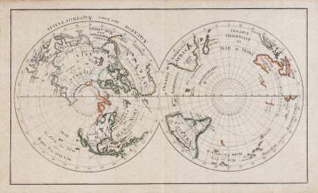
Aequator sive linea Aequinoctialis
AnonymousReference 11742
Description
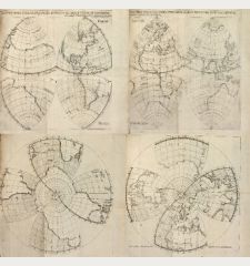
A very rare double hemisphere world map in unusual polar equidistant projection.
Based on the coastline of Australia and New Zealand, one would expect a period of origin in the late 17th century. However, due to the presence of Tahiti, the map was probably engraved circa 1770. The notations are mainly written in Latin, but full of Italian words, suggesting an origin in Italy. The engraving is very skillfully executed, the lettering is highly accurate in style and positioning.
Despite intensive research, we could not find another copy of this map. This sheet may be the only one, or at least one of very few existent copies. Probably the sheet was not bound in a book, since there is no guard for binding. The paper is uncut on three sides, which also indicates to a single-sheet print.
Details
| Cartographer | Anonymous |
| Title | Aequator sive linea Aequinoctialis |
| Publisher, Year | circa 1770 |
| Plate Size | 28.3 x 47.9 cm (11.1 x 18.9 inches) |
| Sheet Size | 33.0 x 63.5 cm (13.0 x 25.0 inches) |
Condition
Images to Download
If you like to download the image of this map with a resolution of 1200 pixels, please follow the link below.
You can use this image for publication on your personal or commercial websites for free if you set a link to this website. If you need photographs with a higher resolution, please contact us.

![Ch'onha Chido [Atlas of all under Heaven] Ch'onha Chido [Atlas of all under Heaven]](https://www.vintage-maps.com/3336-home_default/anonymous-korean-manuscript-atlas-chonha-chido-1820.jpg)
![Ch'onha chido [Atlas of all under Heaven] Ch'onha chido [Atlas of all under Heaven]](https://www.vintage-maps.com/3314-home_default/anonymous-korean-woodblock-atlas-chonha-chido-1750.jpg)
