Product successfully added to your shopping cart
There are 0 items in your cart. There is 1 item in your cart.
Total products
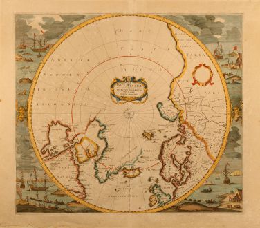
Poli Arctici et Circumiacentium Terrarum descriptio novissima
Jodocus Hondius (*1563 - †1612)Old coloured map of the North Pole. Printed in Amsterdam in the year 1638.
Reference 10145
Description
Very attractive Polar map by Henricus Hondius. It was publish first 1636 for the English edition of the Mercator Hondius Atlas after the Mercator map of the North Pole from 1595 became obsolete. First two states did not contain the attractive whale hunting scenes in the borders, this third state from 1638 showing the beautiful details of the whaling industry in early 17th century. During this time English and Dutch industry competed in the Polar region, which appears in the place names of this map, e.g. Q.Elisabeths forland at the east coast of Greenland or London coast at the west coast. The Dutch recognised in Labrador / Newfoundland with Orange Bay and Hollantsche Bay.
Details
| Cartographer | Jodocus Hondius |
| Title | Poli Arctici et Circumiacentium Terrarum descriptio novissima |
| Publisher, Year | Amsterdam, 1638 |
| Plate Size | 43.5 x 49.5 cm (17.1 x 19.5 inches) |
| Reference | Koeman 0020:1B |
Condition
Overall browning and some age spotting in places. Some waterstains in lower margin. Three margins backed with paper from former framing. Overall very good conditions with beautiful original hand colouring.
Cartographer
Jodocus Hondius was born 1563 in Wakken (West Flanders). He became a globe maker and map engraver. In 1593 he set up his business in Amsterdam after he spent several years in London. He was one of the most important engravers of his time and engraved maps for van den Keere, Waghenaer and Speed. Hondius bought the plates of Mercator in 1604, added around 40 maps and published the expanded Mercator-Atlas first 1606 still under Mercator's name. After his death 1612 in Amsterdam, the business was carried out by his sons Jodocus II and Henricus.
Images to Download
If you like to download the image of this map with a resolution of 1200 pixels, please follow the link below.
You can use this image for publication on your personal or commercial websites for free if you set a link to this website. If you need photographs with a higher resolution, please contact us.
Jodocus Hondius: Poli Arctici et Circumiacentium Terrarum descriptio novissima.
Old coloured map of the North Pole. Printed in Amsterdam in the year 1638.
North - South Pole - Hondius, Jodocus - Poli Arctici et Circumiacentium Terrarum...

