Product successfully added to your shopping cart
There are 0 items in your cart. There is 1 item in your cart.

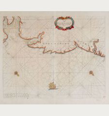
Paskaerte van de Bocht van Vranckrijck, Biscajen en Galissen.
Johannes Loots (*1665 - †1726)Reference 12617
Description
Rare sea chart of the Bay of Biscay by Johannes Loots. Shows the gulf of the northeast Atlantic Ocean (Golfe de Gascogne) from Galicia to Brittany along the north coast of Spain and the west coast of France. With Bilbao, Ferrol, Gijon, Santander, St. Jean de Luz, Bajonne, Bordeaux and Brest. With a title cartouche, a mileage scale and a compass rose surrounded by rhumb lines.
This nautical chart of the Bay of Biscay was already published in a similar form by Pieter Goos with different cartouches and with two ships. However, the map by Goos is more frequently found.
Old doubled on blue paper. Nautical charts not bound in atlases and intended for navigation at sea were often reinforced with a second sheet, as seen here. This made them easier to handle and a suitable set of different maps could be taken along on the planned voyage.
Rarity:
All sea charts by Johannes Loots are extremely rare, as they were mostly sold as single sheets and used for navigation at sea. Usually, antique maps are preserved over the centuries only if they were protected and bound in a book or atlas. Only a few atlases by Johannes Loots are known, one with 14 nautical charts is hold by the Library of Congress, Washington. This map of the Bay of Biscay offered here is also bound into this sea atlas: https://www.loc.gov/item/2011586011/
Until 2011, only 5 charts by Johannes Loots were listed in the AMPR. For comparison: 720 charts by Johannes van Keulen can be found in the AMPR.
Details
| Cartographer | Johannes Loots |
| Title | Paskaerte van de Bocht van Vranckrijck, Biscajen en Galissen. |
| Publisher, Year | Johannes Loots, Amsterdam, circa 1700 |
| Plate Size | 51.1 x 59.0 cm (20.1 x 23.2 inches) |
| Sheet Size | 53.6 x 59.5 cm (21.1 x 23.4 inches) |
Condition
Cartographer
Images to Download
If you like to download the image of this map with a resolution of 1200 pixels, please follow the link below.
You can use this image for publication on your personal or commercial websites for free if you set a link to this website. If you need photographs with a higher resolution, please contact us.
Atlantic Ocean - Loots, Johannes - Paskaerte van de Bocht van Vranckrijck,...

![[Manuscript Chart of the South Atlantic Ocean] Tweede stuck wassende Graedkaert van de Kaap Verdische Eilanden tot de Kaap [Manuscript Chart of the South Atlantic Ocean] Tweede stuck wassende Graedkaert van de Kaap Verdische Eilanden tot de Kaap](https://www.vintage-maps.com/3745-home_default/blaeu-manuscript-1690.jpg)

![[Canary Islands] [Canary Islands]](https://www.vintage-maps.com/3021-home_default/bordone-spain-portugal-canaries-tenerife-gran-canaria.jpg)
![[Porto Santo and Madeira] [Porto Santo and Madeira]](https://www.vintage-maps.com/3025-home_default/bordone-spain-portugal-porto-santo-madeira-1528-1565.jpg)