Product successfully added to your shopping cart
There are 0 items in your cart. There is 1 item in your cart.

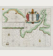
The River Humber - Is most Humbly Dedicated and Presented To the Worshipll. Corporation...
Greenville Collins (*1643 - †1694)Reference 11785
Description
Decorative antique sea chart of the Humber estuary with parts of Yorkshire and Lincolnshire at the east coast of England. It shows the Humber from Barton, Kingston-upon-Hull, Paull, Grimsby up to Spurn.
Decorated with rhumb lines, a compass rose and a richly decorated title cartouche. In addition to sandbanks and anchorages, also water depths are indicated.
From Great Britain's Coasting Pilot. Being a New and Exact Survey of the Sea-Coast of England by Captain Greenville Collins. First printed in 1693 by Freeman Collins in London. The charts were reissued until 1792.
Details
| Cartographer | Greenville Collins |
| Title | The River Humber - Is most Humbly Dedicated and Presented To the Worshipll. Corporation of Trinity House at Kingston upon Hull... |
| Publisher, Year | Freeman Collins, London, 1693-1792 |
| Plate Size | 44.6 x 56.7 cm (17.6 x 22.3 inches) |
| Sheet Size | 52.5 x 60.7 cm (20.7 x 23.9 inches) |
Condition
Cartographer
Captain Greenville Collins (also spelt Greenvill or Greenvile) was an English captain and officer of the Royal Navy. In 1676 he served as a master of the Speedwell. The ship was wrecked off Novaya Zemlya, but the crew was rescued. Based on his journal of the voyage, Charles II drew attention to him and commissioned him to survey the coasts of Great Britain in 1681.
In 1693 he published his atlas Great Britain's Coasting Pilot containing tide tables, coastal views, and 49 sea charts of the coasts of England and Scotland. The Coasting Pilot was printed by his cousin Freeman Collins and sold by Richard Mount. Until the 19th century, 21 additional editions appeared. The sea charts were not very accurate, but an enormous advance against older charts. Collins was not only the first English hydrographer, but also one of the best.
Images to Download
If you like to download the image of this map with a resolution of 1200 pixels, please follow the link below.
You can use this image for publication on your personal or commercial websites for free if you set a link to this website. If you need photographs with a higher resolution, please contact us.
Sea Charts - Collins, Greenville - The River Humber - Is most Humbly...

![[Manuscript Chart of the South Atlantic Ocean] Tweede stuck wassende Graedkaert van de Kaap Verdische Eilanden tot de Kaap [Manuscript Chart of the South Atlantic Ocean] Tweede stuck wassende Graedkaert van de Kaap Verdische Eilanden tot de Kaap](https://www.vintage-maps.com/3745-home_default/blaeu-manuscript-1690.jpg)

![[The Firth of Murry] - To the Rt Hon.ble, my Lord Viscount Torbat, Lord Register of the Kingdom of Scotland [The Firth of Murry] - To the Rt Hon.ble, my Lord Viscount Torbat, Lord Register of the Kingdom of Scotland](https://www.vintage-maps.com/2244-home_default/collins-scotland-north-sea-moray-firth-inverness.jpg)