Product successfully added to your shopping cart
There are 0 items in your cart. There is 1 item in your cart.

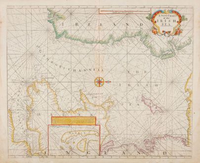
A New Chart of the Irish Sea
John Thornton (*1641 - †1708)Reference 12690
Description
Details
| Cartographer | John Thornton |
| Title | A New Chart of the Irish Sea |
| Publisher, Year | Samuel Thornton, London, circa 1711 |
| Plate Size | 50.2 x 57.7 cm (19.8 x 22.7 inches) |
| Sheet Size | 53.3 x 60.3 cm (21.0 x 23.7 inches) |
Condition
Cartographer
John Thornton was an English cartographer in the second half of the 17th century. He called himself Hydrograph to the Hudson Bay Company and the East India Company, but there is no evidence of his activity for the companies. In 1677 he entered into a partnership with John Seller together with William Fisher, John Colson and James Atkinson, which lasted only until 1679. Thornton and his colleague took over much of Seller's business. After Thornton's death in 1708, his son Samuel took over the business, but he died shortly afterwards and the stock was finally taken over by Mount and Page.
In Thornton's name the following atlases appeared among others:
- The English Pilot. The Third Book, 1703-11
- The English Pilot. The Fourth Book, 1689
- Atlas Maritimus, 1685, 1700, 1708.
- Hydrographia Galliae: The Sea Coasts of France, 1695
Images to Download
If you like to download the image of this map with a resolution of 1200 pixels, please follow the link below.
You can use this image for publication on your personal or commercial websites for free if you set a link to this website. If you need photographs with a higher resolution, please contact us.


