Product successfully added to your shopping cart
There are 0 items in your cart. There is 1 item in your cart.
Total products

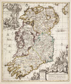
Hyberniae Regni in Provincias Ultoniam, Connachian, Lageniam, Momoniamq Divisi Tabula...
Carel Allard (*1648 - †1709)Old coloured map of Ireland. Printed in Amsterdam by Covens & Mortier circa 1730.
Reference 12541
Description
Rare old coloured antique map of Ireland by Carel Allard. This is the edition by Covens and Mortier. Two impressive cartouches, numerous sailing ships in the Atlantic and Irish Seas. Very nice strong impression.
Details
| Cartographer | Carel Allard |
| Title | Hyberniae Regni in Provincias Ultoniam, Connachian, Lageniam, Momoniamq Divisi Tabula Accuratissima ... |
| Publisher, Year | Covens & Mortier, Amsterdam, circa 1730 |
| Plate Size | 58.6 x 49.6 cm (23.1 x 19.5 inches) |
| Sheet Size | 63.0 x 53.0 cm (24.8 x 20.9 inches) |
Condition
Centrefold backed in lower part. Excellent condition with old outline color. Very nice strong impression. Never framed before.
Cartographer
Hugh Allard and his son Carel were map and atlas publishers in the second half of seventeenth century in Amsterdam. The maps mainly based on those of J. Blaeu, N. Visscher, J. Janssonius and F. de Wit.
Images to Download
If you like to download the image of this map with a resolution of 1200 pixels, please follow the link below.
You can use this image for publication on your personal or commercial websites for free if you set a link to this website. If you need photographs with a higher resolution, please contact us.
Carel Allard: Hyberniae Regni in Provincias Ultoniam, Connachian, Lageniam, Momoniamq Divisi Tabula Accuratissima ....
Old coloured map of Ireland. Printed in Amsterdam by Covens & Mortier circa 1730.
Ireland - Allard, Carel - Hyberniae Regni in Provincias Ultoniam,...


