Product successfully added to your shopping cart
There are 0 items in your cart. There is 1 item in your cart.
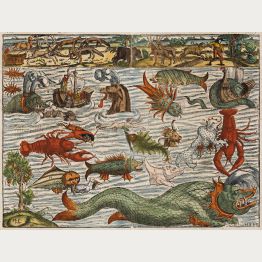
Sea Monsters

America
Henricus Hondius, Amsterdam, 1628
This map, engraved by Jodocus Hondius the Elder, is a finely colored example of a highly sought-after map of America. It was created in 1604 for Hondius' first edition of the Mercator Atlas Sive...
America
1628 - Jodocus Hondius
12765Coloured map of the American continent. Printed in Amsterdam by Henricus Hondius in 1628.
Sold
Virginiae Item et Floridae Americae Provinciarum, nova Descriptio
Henricus Hondius, Amsterdam, 1628
One of the great early maps of the North-American South, before the Jamestown colony was established. The Mercator-Hondius map of Virginia and Florida, originally published in 1606 by Jodocus...
Virginiae Item et Floridae Americae Provinciarum, nova Descriptio
1628 - Jodocus Hondius
12769Coloured map of Virginia and Florida. Printed in Amsterdam by Henricus Hondius in 1628.
Sold
America Meridionalis
Henricus Hondius, Amsterdam, 1628
This highly sought-after map of South America was engraved by Jodocus Hondius. It is one of the earliest decorative maps available that depicts the South American continent. The map includes the...
America Meridionalis
1628 - Jodocus Hondius
12772Coloured map of South America. Printed in Amsterdam by Henricus Hondius in 1628.
Sold
Paraguay, o Prov. de Rio de la Plata cum regionibus adiacentibus Tucuman et S.ta Cruz de la Sierra
1630
Attractive map of Paraguay. Wtih 2 cartouche and a seamonster.
Paraguay, o Prov. de Rio de la Plata cum regionibus adiacentibus Tucuman...
1630 - Willem Janszoon Blaeu
10052Antique map of Paraguay. Printed in the year 1630.
Sold
Nova Illustrissimi Ducatus Pomeraniae Tabula
J. Janssonius, Amsterdam, circa 1630
Antique map of Pomerania by Johannes Janssonius. Shows the Baltic coast from Stralsund with Rügen and Usedom to Gdansk. With Szczecin and Toruń. Decorated with 3 cartouches, the portrait of...
Nova Illustrissimi Ducatus Pomeraniae Tabula
1630 - Johannes Janssonius
12564Coloured map of Pomerania. Printed in Amsterdam by J. Janssonius circa 1630.
Sold
Typus Frisiae Orientalis
Johannes Janssonius, Amsterdam, 1630 [1633]
Beautiful map of East Frisia by Johannes Janssonius after Ubbo Emmius. Showing the North Sea coast of Friesland between Dollart and the Jadebusen with Emden, Leer and the East Frisian Islands...
Typus Frisiae Orientalis
1630 - Johannes Janssonius
12663Old coloured map of East Frisia, Ostfriesland. Printed in Amsterdam by Johannes Janssonius in 1633.
Sold
Africae nova tabula
circa 1633
Attractive coloured map of Africa. Various animals appear in Africa, seamonsters and fishes in the ocean. It was publish first 1619 by Jodocus Hondius with four decorative borders (state 1). After...
Africae nova tabula
1633 - Jodocus Hondius
10075Coloured map of the African continent. Printed circa 1633.
Sold
Europa Exactissime Descripta
Henricus Hondius, Amsterdam, 1633
A beautiful example of Hondius' map of Europe with attractive colors.The map provides a detailed depiction of Europe, including the names of cities, mountains, and rivers. It also features...
Europa Exactissime Descripta
1633 - Jodocus Hondius
12767Coloured map of the European continent. Printed in Amsterdam by Henricus Hondius in 1633.
Sold
Nova Totius Terrarum Orbis Geographica Ac Hydrographica Tabula Auct. Henr: Hondio. . . . 1630
Henricus Hondius, Amsterdam, 1633
Rare Early Edition of the First State of One of the Most Famous World Maps of the 17th Century.A very fine example of the first state of Henricus Hondius' celebrated world map. This is one...
Nova Totius Terrarum Orbis Geographica Ac Hydrographica Tabula Auct....
1633 - Jodocus Hondius
12775Coloured map of the world. Printed in Amsterdam by Henricus Hondius in 1633.
Sold
Situs Terrae Promissionis.S.S.Bibliorum intelligentiam.
H. Hondius, Amsterdam, 1633
A magnificent map of the Holy Land by H. Hondius based on the influential work of Christian Van Adrichom. The map is intricately engraved and features a wealth of biblical scenes, including the...
Situs Terrae Promissionis.S.S.Bibliorum intelligentiam.
1633 - Jodocus Hondius
12815Coloured map of the Holy Land. Printed in Amsterdam by H. Hondius in 1633.
Sold
Daniae Regnu
H. Hondius, Amsterdam, 1633
Beautiful coloured antique map of Denmark by Gerard Mercator. Shows Denmark with Holstein and Mecklenburg with Rügen in the south and south Sweden in the north. Top right a title cartouche, in the...
Daniae Regnu
1633 - Gerard Mercator
12833Coloured map of Denmark. Printed in Amsterdam by H. Hondius in 1633.
Sold
Islandia
H. Hondius, Amsterdam, 1633
The second map based on local Icelandic data.This impressive map showcases Iceland and is attributed to the famous cartographer Gerhard Mercator. It was featured in the Atlas sive...
Islandia
1633 - Gerard Mercator
12845Coloured map of Iceland. Printed in Amsterdam by H. Hondius in 1633.
Sold
Peru
Janssonius, Amsterdam, 1633
Beautiful antique map of Peru by Johannes Janssonius. Showing Peru with an eastward orientation, delineates the colony along its Pacific coast. The rugged, mountainous terrain dominates the...
Peru
1633 - Johannes Janssonius
12868Coloured map of Peru. Printed in Amsterdam by Janssonius in 1633.
Sold
Freti Magellanici ac Novi Freti vulgo Le Maire Exactissima Delineatio
J. Hondius, Amsterdam, 1633
This beautiful antique map by Hondius vividly captures the Straits of Magellan, Le Maire Strait, Tierra del Fuego, and the southern tip of Patagonia. The coastlines of Tierra del Fuego are...
Freti Magellanici ac Novi Freti vulgo Le Maire Exactissima Delineatio
1633 - Jodocus Hondius
12881Coloured map of the Strait of Magellan, Tierra del Fuego. Printed in Amsterdam by J. Hondius in 1633.
Sold
Typus Frisiae Orientalis
Johannes Janssonius, Amsterdam, 1633
Beautiful map of East Frisia by Johannes Janssonius after Ubbo Emmius. Showing the North Sea coast of Friesland between Dollart and the Jadebusen with Emden, Leer and the East Frisian Islands...
Typus Frisiae Orientalis
1633 - Johannes Janssonius
12884Coloured map of East Frisia, Ostfriesland. Printed in Amsterdam by Johannes Janssonius in 1633.
Sold
Paraguay, o Prov. de Rio de la Plata cum Regionibus Adiacentibus Tucuman et Sta. Cruz de la Sierra
J. Hondius, Amsterdam, 1633
Beautiful map centered on Paraguay by J. Janssonius. With Uruguay, Bolivia and parts of Argentina, Brazil, Peru and Chile. Including the Paraguay River basin, the Peru-Chilean coast, and Lake...
Paraguay, o Prov. de Rio de la Plata cum Regionibus Adiacentibus Tucuman...
1633 - Johannes Janssonius
12891Coloured map of Paraguay, La Plata Basin. Printed in Amsterdam by J. Hondius in 1633.
Sold
Nova Italiae Delineatio
circa 1635
Beautiful full old coloured example of Blaeu's first map of Italy. Showing whole Italy with Sardinia, Corsica and parts of Sicily. With several sailing ships and a sea monster. German text on verso.
Nova Italiae Delineatio
1635 - Willem Janszoon Blaeu
10312Coloured map of Italia. Printed circa 1635.
Sold
Insulae Americanae in Oceano Septentrionali, cum Terris Adiacentibus
J. Blaeu, Amsterdam, 1635 (1662)
W. Blaeu's coastal chart of the West IndiesHand-coloured engraved sea chart of the West Indies by W. Blaeu. With the East Coast of the Americas from Chesapeake Bay to the Orinoco. First...
Insulae Americanae in Oceano Septentrionali, cum Terris Adiacentibus
1635 - Willem Janszoon Blaeu
11447Coloured sea chart of Florida, West Indies. Printed in Amsterdam by J. Blaeu in 1662.
Sold
Nova et accurata Tabula Episcopatuum Stavangriensis, Bergensis et Asloiensis Vicinarumque aliquot...
Amsterdam, 1636
Original old coloured map of southern Norway by J. Janssonius. Showing the area between Oslo, Stavanger and Bergen. Decorated with a figural cartouche with mileage scale, a allegoric cartouche with...
Nova et accurata Tabula Episcopatuum Stavangriensis, Bergensis et...
1636 - Johannes Janssonius
10878Old coloured map of Bergen, Stavanger, Oslo, Norway. Printed in Amsterdam in the year 1636.
Sold
Hibernia Regnum vulgo Ireland. Amstelodami, Apud Ioannem Ianssonium
Amsterdam, circa 1636
Original old hand coloured map of Ireland by J. Janssonius. One of the most beautiful maps of Ireland. Decorative title cartouche with the Irish harp and Royal arms above. Showing the coasts of...
Hibernia Regnum vulgo Ireland. Amstelodami, Apud Ioannem Ianssonium
1636 - Johannes Janssonius
11445Old coloured map of the British Islands. Printed in Amsterdam circa 1636.
Sold
Poli Arctici et Circumiacentium Terrarum descriptio novissima
Amsterdam, 1638
Very attractive Polar map by Henricus Hondius. It was publish first 1636 for the English edition of the Mercator Hondius Atlas after the Mercator map of the North Pole from 1595 became obsolete....
Poli Arctici et Circumiacentium Terrarum descriptio novissima
1638 - Jodocus Hondius
10145Old coloured map of the North Pole. Printed in Amsterdam in the year 1638.
Sold
Africa
Giunti, Venice, circa 1640
Very rare copper engraved Africa Map of G. Botero. This example has a thin engraved line around the continent, which is not described in references. It seems the map comes from 1640 edition of...
Africa
1640 - Giovanni Botero
10316Antique map of Africa. Printed in Venice by Giunti circa 1640.
Sold![Blaeu, World and Continents, 1640: Nova Totius Terrarum Orbis Geographica ac Hydrographica Tabula auct: Guiljelmo Blaeuw [and] Africae nova descriptio [and]...]( "Willem Janszoon Blaeu: Nova Totius Terrarum Orbis Geographica ac Hydrographica Tabula auct: Guiljelmo Blaeuw [and] Africae nova descriptio [and]...")
Nova Totius Terrarum Orbis Geographica ac Hydrographica Tabula auct: Guiljelmo Blaeuw [and]...
Amsterdam, circa 1640
A matching set of the World and the Continents by Willem J. Blaeu These five maps represent the apogee of seventeenth century Dutch cartography. With their decorative panels of costumed figures,...
Nova Totius Terrarum Orbis Geographica ac Hydrographica Tabula auct:...
1640 - Willem Janszoon Blaeu
11061Old coloured world map and continent maps with borders by Willem J. Blaeu. Published around 1640 in Amsterdam.
Sold
Insulae Americanae in Oceano Septentrionali, cum Terris adiacentibus
Willem & Joan Blaeu, Amsterdam, 1640-43
Blaeu's Striking Sea Chart of the West IndiesHand-coloured antique sea chart of the West Indies by Willem Blaeu. With the East Coast of the Americas from Chesapeake Bay to the Orinoco. First...
Insulae Americanae in Oceano Septentrionali, cum Terris adiacentibus
1640 - Willem Janszoon Blaeu
11919Coloured sea chart of the West Indies, Florida. Printed in Amsterdam by Willem & Joan Blaeu in 1640.
Sold


![Blaeu, World and Continents, 1640: Nova Totius Terrarum Orbis Geographica ac Hydrographica Tabula auct: Guiljelmo Blaeuw [and] Africae nova descriptio [and]...](https://www.vintage-maps.com/1213-home_default/blaeu-world-and-continents-1640.jpg "Willem Janszoon Blaeu: Nova Totius Terrarum Orbis Geographica ac Hydrographica Tabula auct: Guiljelmo Blaeuw [and] Africae nova descriptio [and]...")
