Product successfully added to your shopping cart
There are 0 items in your cart. There is 1 item in your cart.
America
Jodocus Hondius (*1563 - †1612)Reference 12765
Description
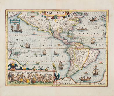
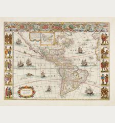
This map, engraved by Jodocus Hondius the Elder, is a finely colored example of a highly sought-after map of America. It was created in 1604 for Hondius' first edition of the Mercator Atlas Sive Cosmographia, using plates acquired just two years prior.
The map showcases the North and South American continents adorned with fantastic beasts, ships, and decorative elements, making it a standout piece in early-seventeenth century mapmaking.
Surrounding the continents are various sea monsters, including flying fish and peculiar alien creatures. The map also features diverse watercraft from different cultures that inhabit the depicted waters. A Japanese square-rigged vessel is seen to the west, while three European vessels sail southward. Near the Strait of Magellan, an indigenous canoe with a fire onboard is accompanied by another European ship. Further north, a second canoe carries a fire, and a note explains that these canoes were hollowed out by fire. Additionally, there is a depiction of a Greenlander in a kayak, holding a trident and wearing what appears to be Santa's hat.
Two cartouches adorn the map. The top center cartouche displays the title "America" within a strapwork design common to the period. The more remarkable cartouche in the bottom left corner depicts Brazilian natives brewing cauim, an alcoholic beverage made from manioc root. The scene illustrates the process, with women chewing the root to aid in fermentation while men consume the drink. These scenes and the indigenous boats are inspired by Theodor DeBry's collections, whom Hondius personally knew.
The map contains an abundance of cartographic details and was intended to be the definitive representation of the continent upon its initial publication. It offers a more accurate depiction of the west coast of South America compared to earlier Mercator maps. Hondius also narrows the continent's width. Notable geographic features include several large lakes, with the largest being a long, thin horizontal lake in Guiana, alluding to Lake Parime associated with Sir Walter Raleigh's voyages.
To the south, the Strait of Magellan separates South America from a large southern continent that extends east and west, curving behind the cartouche. This configuration reflects the common belief of the time, as the circumnavigation by Willem Schouten and Jacob Le Maire from 1615 to 1617 had not yet proven Tierra del Fuego to be an island.
In the Pacific, various islands are scattered, including Tuberones (Shark Island) and S. Petro (St. Peter's Island), formerly referred to as the Unfortunate Islands by Magellan. New Guinea is partially visible on the left side of the map.
Unlike its counterpart, the projection of North America retains its width, particularly in the north. Virginia's east coast is depicted as a blockish peninsula stretching far east into the Atlantic Ocean. Towards the northwest, the coastline extends nearly due west, separated from Asia by the famed Strait of Anian, which was believed to be a passage to China, known as the Northwest Passage, until the mid-eighteenth century. The term Anian is derived from Marco Polo's travels, specifically referring to a Chinese province located on a gulf (Gulf of Tonkin), but later transposed to the northwest coast of North America by mapmakers like Giacomo Gastaldi, Zaltieri, and Mercator.
Another significant cartographic feature on this map is the inclusion of Quivira Regnum near Anian Regn. Quivira refers to the Seven Cities of Gold sought by the Spanish explorer Francisco Vasquez de Coronado in 1541. Although Coronado never found the cities or the gold, the name persisted on maps of the southwest region of North America, gradually shifting from east to west. Here, it describes the entire southwestern region of North America.
Details
| Cartographer | Jodocus Hondius |
| Title | America |
| Publisher, Year | Henricus Hondius, Amsterdam, 1628 |
| Plate Size | 37.3 x 49.7 cm (14.7 x 19.6 inches) |
| Sheet Size | 47.7 x 56.7 cm (18.8 x 22.3 inches) |
| Reference | Van der Krogt, P.: Koeman's Atlantes Neerlandici, 9000:1B; Burden, P.D.: The Mapping of North America No. 150 |
Condition
Cartographer
Images to Download
If you like to download the image of this map with a resolution of 1200 pixels, please follow the link below.
You can use this image for publication on your personal or commercial websites for free if you set a link to this website. If you need photographs with a higher resolution, please contact us.

