Product successfully added to your shopping cart
There are 0 items in your cart. There is 1 item in your cart.
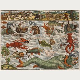
Sea Monsters

Natolia, quae olim Asia Minor.
Willem & Joan Blaeu, Amsterdam, 1640-43
Old coloured antique map of Asia Minor with Turkey and Cyprus by Willem Blaeu. With Constantinople (Istanbul), Smyrna (Izmir) and Antioch. Decorated with a beautiful title cartouche, sea monsters...
Natolia, quae olim Asia Minor.
1640 - Willem Janszoon Blaeu
12035Old coloured map of Turkey. Printed in Amsterdam by Willem & Joan Blaeu in 1640.
Sold
Novus Brasiliae Typus
W. J. Blaeu, Amsterdam, 1640-43
Antique map of Brazil by Willem J. Blaeu. Shows a very detailed and accurate coastline while the interior is still speculative. With an inset maps of Baya de Todos os Sanctos (Bay of All Saints)....
Novus Brasiliae Typus
1640 - Willem Janszoon Blaeu
12759Coloured map of Brazil. Printed in Amsterdam by W. J. Blaeu in 1640.
Sold
Africae nova descriptio
Amsterdam, 1641-42
One of the most sought after maps of Africa.A very good example of Blaeu's iconic 17th-century map of Africa. It features the African continent with the Arabian Peninsula in the upper right...
Africae nova descriptio
1641 - Willem Janszoon Blaeu
12857Antique map of Africa with borders by Willem J. Blaeu. Published 1641 in Amsterdam.
Sold
Europam sive Celticam veterem. Sic Describere conabur Abrahamus Ortelius
Amsterdam, 1642
Historical map of Europe, originally attributed to Ortelius also published in Hondius / Mercator Atlas Novus with different catouches. French text on back.
Europam sive Celticam veterem. Sic Describere conabur Abrahamus Ortelius
1642 - Johannes Janssonius
10151Old coloured map of the European continent. Printed in Amsterdam in the year 1642.
Sold
Nova Totius Terrarum Orbis Geographica ac Hydrographica Tabula auct: Guiljelmo Blaeuw.
Amsterdam, 1643-50
One of the Most Famous World Maps of Dutch Cartography with Stunning Old Colours.Perhaps the finest world map ever printed. This map represents the apogee of seventeenth century Dutch...
Nova Totius Terrarum Orbis Geographica ac Hydrographica Tabula auct:...
1643 - Willem Janszoon Blaeu
11522Old coloured world map with borders by Willem J. Blaeu. Published 1643 in Amsterdam.
Sold
Aethiopia Inferior, vel Exterior.
Joan Blaeu, Amsterdam, 1644-55
Engraved antique map of South Africa by Joan Blaeu. The beautiful cartouche shows tribal warriors with spears and bows, including turtles and monkeys. With sailing ships and various wild animals of...
Aethiopia Inferior, vel Exterior.
1644 - Willem Janszoon Blaeu
11776Coloured map of South Africa. Printed in Amsterdam by Joan Blaeu in 1644.
Sold
Europa recens descripta a Guilielmo Blaeuw
Amsterdam, 1644-1655
Blaeu's famous Map of Europe with Beautiful Old Colours.A striking and highly decorative map of Europe by Willem J. Blaeu, produced at the height of the Golden Age of Dutch mapmaking. With...
Europa recens descripta a Guilielmo Blaeuw
1644 - Willem Janszoon Blaeu
12753Old coloured map of Europe with borders by Willem J. Blaeu. Published 1644-55 in Amsterdam.
Sold
Normandia Ducatus
circa 1650
Very attractive map of the Normandy in France with the Channel to UK. Various ships and coats of arms are shown.
Normandia Ducatus
1650 - Johannes Janssonius
10012Coloured map of the Normandy. Printed circa 1650.
Sold
Normandia Ducatus
Amsterdam, circa 1650
Very attractive map of the Normandy in France with the Channel to England by Jan Jansson. Various ships and coats of arms are shown.
Normandia Ducatus
1650 - Johannes Janssonius
10102Coloured map of the Normandy. Printed in Amsterdam circa 1650.
Sold
Aethiopia Inferior vel Exterior Monomotapa
M. Merian, Frankfurt, circa 1650
Nice engraved map of South Africa from M. Merian based on the Blaeu map. With a beautiful cartouch with turtles and monkeys. With several ships and animals.
Aethiopia Inferior vel Exterior Monomotapa
1650 - Matthäus Merian
10592Antique map of South Africa. Printed in Frankfurt by M. Merian circa 1650.
Sold
Guinea
circa 1660
Very attractive map of Guinea and Benin. Various animals and ships are shown. Dutch text on verso.
Guinea
1660 - Johannes Janssonius
10009Old coloured map of Benin, Guinea. Printed circa 1660.
Sold
Insulae Acores Delineante Ludovico Teisera
Joan Blaeu, Amsterdam, 1662
Highly decorative sea chart of the Azores Islands. At the upper left the northwestern islands of Corvo and Flores, in the middle the central archipelago with Faial, Pico, São Jorge, Graciosa and...
Insulae Acores Delineante Ludovico Teisera
1662 - Willem Janszoon Blaeu
11775Old coloured sea chart of the Azores Islands. Published by Joan Blaeu in Amsterdam in 1662.
Sold
Orbis Terrarum Tabula Recens Emendata et in Lucem Edita per N. Visscher
Visscher, Amsterdam, 1663
Attractive coloured worldmap in double hemisphere with two inset astronomical diagrams. From a dutch bible. Surround with allegorical representation of the continents. Visschers second worldmap.
Orbis Terrarum Tabula Recens Emendata et in Lucem Edita per N. Visscher
1663 - Nicolas Visscher
10688Coloured map of the world. Printed in Amsterdam by Visscher in 1663.
Sold
Orbis Terrarum Tabula Recens Emendata et in Lucem Edita per N. Visscher
Visscher, Amsterdam, 1663
Beautiful coloured antique world map in double hemisphere with two inset astronomical diagrams. From the Elzevier Dutch bible printed in 1663. Surrounded with allegorical representation of the...
Orbis Terrarum Tabula Recens Emendata et in Lucem Edita per N. Visscher
1663 - Nicolas Visscher
11885Coloured map of the world. Printed in Amsterdam by Visscher in 1663.
Sold
Sevende Stuck der Aerdrycks-Beschryving, Welck Vervat Italien en Griecken.
Joan Blaeu, Amsterdam, 1664-65
A splendid copy of Blaeu's Atlas of Italy and Greece. All 67 maps finely coloured by a contemporary hand.The Italy and Greece Atlas of Atlas Maior by Joan Blaeu is considered as one of the...
Sevende Stuck der Aerdrycks-Beschryving, Welck Vervat Italien en Griecken.
1664 - Willem Janszoon Blaeu
12079Atlas of Italy and Greece from Atlas Maior by Joan Blaeu. Printed 1664 in Amsterdam.
Sold
Terra di Lavoro, olim Campania Felix
Joan Blaeu, Amsterdam, 1664-65
Old coloured map of Campania with Naples and the Islands Ponza, Ventotene and Ischia by Willem Blaeu. Decorated with two cartouches, a coat of arms and two sailing ships. First published in Blaeu's...
Terra di Lavoro, olim Campania Felix
1664 - Willem Janszoon Blaeu
12437Old coloured map of Campania. Printed in Amsterdam by Joan Blaeu in 1664.
Sold
Nova Totius Terrarum Orbis Tabula ex Officina F. de Wit Amstelodami
Frederick de Wit, Amsterdam, 1668-70
Engraved by the Dutch Master Romeyn de Hooghe.Rare first state of Frederick de Wit's fine maritime world map. One of the most decorative world maps of the 17th century and maybe the best...
Nova Totius Terrarum Orbis Tabula ex Officina F. de Wit Amstelodami
1668 - Frederick de Wit
12419Antique world map by Frederick de Wit, engraved by Romeyn de Hooghe. Published in Amsterdam around 1668.
Sold![Adams, British Isles, England and Wales, 1679 (1699): [Angliae totius tabula...] - An Alphabeticall Table of all the Cities and Market Towns in England and Wales - Serenissimo ac...]( "John Adams: [Angliae totius tabula...] - An Alphabeticall Table of all the Cities and Market Towns in England and Wales - Serenissimo ac...")
[Angliae totius tabula...] - An Alphabeticall Table of all the Cities and Market Towns in England...
Philip Lea, London, 1679 (1699)
John Adams's Exceptionally Rare Distance Map of England and Wales.A very rare large map of England and Wales by John Adams. This is the 2-sheet version of his 12-sheet wall map of 1677...
[Angliae totius tabula...] - An Alphabeticall Table of all the Cities...
1679 - John Adams
12435Old coloured map of England and Wales. Printed in London by Philip Lea in 1699.
Sold
Orbis Terrarum Tabula Recens Emendata et in Lucem Edita
circa 1680
World map from a Dutch bible of Daniel Stoopendael in beautiful hand colouring. The map is based on Nicolas Visscher's map of 1663. Showing double-hemisphere world map with two solar charts, one...
Orbis Terrarum Tabula Recens Emendata et in Lucem Edita
1680 - Daniel Stoopendaal
10689Coloured map of the world. Printed circa 1680.
Sold
Nova et Accurata Totius Europae Descriptio
F. de Wit, Amsterdam, 1680
Beautiful original old coloured map of Europe by Frederick de Wit. Richly decorated with many ships, a sea monster and putti holding the title banner. Europa rides on Zeus in the form of a bull....
Nova et Accurata Totius Europae Descriptio
1680 - Frederick de Wit
11510Old coloured map of the European continent. Printed in Amsterdam by F. de Wit in 1680.
Sold
Orbis Terrarum Tabula Recens Emendata et in Lucem Edita
Rotterdam, circa 1680
Hand coloured world map from a Dutch bible by Daniel Stoopendael. The map is based on Nicolas Visscher's map of 1663. Showing double-hemisphere world map with two solar charts, one centred around...
Orbis Terrarum Tabula Recens Emendata et in Lucem Edita
1680 - Daniel Stoopendaal
11523Coloured map of the world. Printed in Rotterdam circa 1680.
Sold
Werelt Caert
Amsterdam, circa 1680
Hand coloured world map from a Dutch bible by Daniel Stoopendaal. The map is based on Nicolas Visscher's map of 1663. Showing a double-hemisphere world map with two solar charts, one centred around...
Werelt Caert
1680 - Daniel Stoopendaal
12143Antique map of the world. Printed in Amsterdam circa 1680.
Sold
Nova Totius Terrarum Orbis Tabula Amstelodami per I. Danckerts cum Privil.
J. Danckerts, Amsterdam, circa 1685
Very decorative double-hemisphere world map by Justus Danckerts. Based on Frederick De Wit's maritime world map of 1668. With two hemispheres and two small inset polar maps. Decorated with large...
Nova Totius Terrarum Orbis Tabula Amstelodami per I. Danckerts cum Privil.
1685 - Justus Danckerts
12418Antique world map by Justus Danckerts. Published around 1685 in Amsterdam.
Sold
Nova Totius Terrarum Orbis Tabula Amstelodami per I. Danckerts cum Privil.
J. Danckerts, Amsterdam, circa 1685
Very decorative double-hemisphere world map by Justus Danckerts. Based on Frederick De Wit's maritime world map of 1668. With two hemispheres and two small inset polar maps. Decorated with large...
Nova Totius Terrarum Orbis Tabula Amstelodami per I. Danckerts cum Privil.
1685 - Justus Danckerts
12859Antique world map by Justus Danckerts. Published around 1685 in Amsterdam.
Sold


![Adams, British Isles, England and Wales, 1679 (1699): [Angliae totius tabula...] - An Alphabeticall Table of all the Cities and Market Towns in England and Wales - Serenissimo ac...](https://www.vintage-maps.com/3369-home_default/adams-british-isles-england-and-wales-1679-1699.jpg "John Adams: [Angliae totius tabula...] - An Alphabeticall Table of all the Cities and Market Towns in England and Wales - Serenissimo ac...")


