Product successfully added to your shopping cart
There are 0 items in your cart. There is 1 item in your cart.
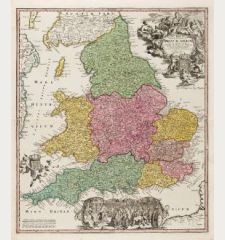
![John Adams: [Angliae totius tabula...] - An Alphabeticall Table of all the Cities and Market Towns in England and Wales - Serenissimo ac... Antique Maps, Adams, British Isles, England and Wales, 1679 (1699): [Angliae totius tabula...] - An Alphabeticall Table of all the Cities and Market Towns in England and Wales - Serenissimo ac...](https://www.vintage-maps.com/3369-large_default/adams-british-isles-england-and-wales-1679-1699.jpg)
[Angliae totius tabula...] - An Alphabeticall Table of all the Cities and Market Towns...
John Adams (†1738)Reference 12435
Description
John Adams's Exceptionally Rare Distance Map of England and Wales.
A very rare large map of England and Wales by John Adams. This is the 2-sheet version of his 12-sheet wall map of 1677 printed 1699 from the original plate. No other maps by John Adams are known.
The first reduced-size version of John Adam's 12-sheet distance map was advertised in the London Gazette in July 1679:
Mr Adams of the Inner-Temple, having formerly published a new large Map of England, wherein an account of Miles is entred in Figures, hath now contracted the same into two Imperial sheets of paper...
The map was for sale at the shop of a stationer, appropriately called Mr. Pen, near the Temple Church. The map shows distance lines with mileages between the towns. Flanked by alphabetical tables of cities and towns with latitude and longitude, their grid reference and the distance from London. With side and bottom borders of intertwined figures and floral extravaganza.
This is the third state of the map, dedicated to William III. Published in London by Philip Lea in 1699. In the lower left corner: Globs Mapps Mathematical Books and Instruments Made and Sold by Phil: Lea. at ye Atlas & Hercules in Cheapside London. A large cartouche with the dedication William III (William of Orange). The county borders are old colour-washed.
Blake Tyson notes in The Geographical Journal about John Adams cartographic career and his map of England and Wales:
John Adams started map-making about 1672 by plotting Welsh market towns within 100 miles of Aberdovey to help a Mr Lloyd of Llanvorda, 2.5 km west of Oswestry, plan his fish marketing. In London he developed his technique to produce 'a large Map of England in Trinity Term 1677 with computed and measured miles entered in Figures' (Adams, 1680). It was 'full six foot square' and priced at two guineas (Phil. Trans., 1677). Topography was not shown and settlements, represented by graded symbols, were joined by a network of straight route lines with mileages, even if no direct road existed between some of them. From this Adams produced a smaller map, also entitled Angliae Torius Tabula.... which recorded in its margins the latitude and longitude of 781 places. From a newspaper advertisement, Professor E. G. R. Taylor (1941) proved its date to be 1679 and demonstrated the involvement of Gregory King in its production by reference to his notebooks in the Salt Library in Stafford.
Rodney W. Shirley in Printed Maps of the British Isles 1650-1750 about John Adams map of England and Wales:
The most striking feature of Adams's map is the prominent linking of towns and villages by straight lines, with the mileages marked so that the distances (as he says) can be ascertained without scale or compass. It is not known if Adams relied entirely on computations for his mileages or whether he consulted Ogilby's survey of 1675 and or the post route tables for road links. Because his distances are direct, or as the crow flies', they normally understate route mileages... Other notable features on Adams's map are the broad ornamental border, the powerful dedicatory cartouche, and the angulated rhumb lines radiating from numerous compass roses in the sea. Like Ogilby's, the longitudinal zero is determined from a north-south line through Greenwich. In one of the decorative panels of text, Adams describes the projection used, based on a planisphere with a radius of 91.74 feet.
Adams's map had an extraordinary vogue for well over a century, as is shown by the large number of reissues and pirated copies which appeared down to the end of the 18th century. Heawood listed 16 versions by Overton, Berry, Brown, Bowles, Moll, Kircher, Sayer and Evans. Shirley expanded the list to a total of 36 versions.
Rarity:
The 12-sheet map and the reduced 2-sheet map of England and Wales by John Adams printed from the original plates are both very rare in all states. We could located 8 examples of the 2-sheet version held in the following institutions:
1st state, dedicated to dedicated to Charles II (1679): Bibliothèque nationale de France, Newberry Library, British Library.
2nd state, dedicated to James II (1688): British Library (lacking title and decorative border).
3rd state, dedicated to William III (1699), always printed without the top title: Bodleian Library, National Library of Scotland (lacks border strip), University of Cambridge Libraries, Admiralty Library (Lea Atlas).
We could find 2 examples which came to the map trade market in the last 40 years. One was sold at Sotheby's sale in November 1986, lot 711, and was acquired by the British Library, see the 2nd state above. Another example was listed in Jonathan Potter's catalogue around 2003.
Details
| Cartographer | John Adams |
| Title | [Angliae totius tabula...] - An Alphabeticall Table of all the Cities and Market Towns in England and Wales - Serenissimo ac Potentissimo Principi D.no Gulielmo III. |
| Publisher, Year | Philip Lea, London, 1679 (1699) |
| Plate Size | 63.5 x 97.5 cm (25.0 x 38.4 inches) |
| Sheet Size | 66.0 x 108.5 cm (26.0 x 42.7 inches) |
| Reference | Shirley, R. W.: Printed Maps of the British Isles 1650-1750, page 22, Adams 2, State 3.; Tyson, B.: John Adams's Cartographic Correspondence to Sir Daniel Fleming... 1676-1687, The Geographical Journal, Vol. 151, No. 1, pp. 21-39.; Ravenhill, W.: John Adams, His Map of England, Its Projection, and His Index Villaris of 1680, The Geographical Journal, 1978, Vol. 144, No. 3, pp. 424-43; Heawood, E.: John Adams and His Map of England, The Geographical Journal, 1932, Vol. 79, No. 1, pp. 37-44. |
Condition
Cartographer
Images to Download
If you like to download the image of this map with a resolution of 1200 pixels, please follow the link below.
You can use this image for publication on your personal or commercial websites for free if you set a link to this website. If you need photographs with a higher resolution, please contact us.
British Isles - Adams, John - [Angliae totius tabula...] - An...


![[British Isles and England & Wales] [British Isles and England & Wales]](https://www.vintage-maps.com/2941-home_default/bordone-british-isles-england-and-wales-1528-1565.jpg)
![[The Firth of Murry] - To the Rt Hon.ble, my Lord Viscount Torbat, Lord Register of the Kingdom of Scotland [The Firth of Murry] - To the Rt Hon.ble, my Lord Viscount Torbat, Lord Register of the Kingdom of Scotland](https://www.vintage-maps.com/2244-home_default/collins-scotland-north-sea-moray-firth-inverness.jpg)
