Product successfully added to your shopping cart
There are 0 items in your cart. There is 1 item in your cart.
Total products
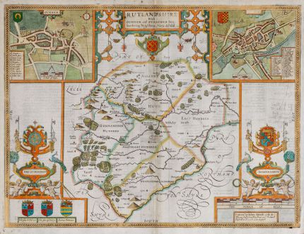
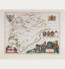
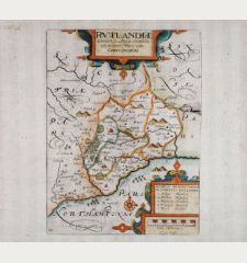
Rutlandshire With Oukham and Stanford her bordering Neighbour Newely described
John Speed (*1552 - †1629)Coloured map of Stamford, Oakham, Rutland, England. Printed in London by T. Bassett and R. Chiswell in 1676.
Reference 11909
Description
Very decorative antique map of Rutland from John Speed's The Theatre of the Empire of Great Britaine. Top left with a city plan of Oakham (Oukham), to the right a plan of Stamford (Stanford). Above the title cartouche, below several coats of arms. English text on verso with a description of Rutland and a key. From the 1676 edition by Thomas Bassett and Richard Chiswell. This map was first published in 1612 by John Sudbury and George Humble.
Details
| Cartographer | John Speed |
| Title | Rutlandshire With Oukham and Stanford her bordering Neighbour Newely described |
| Publisher, Year | T. Bassett and R. Chiswell, London, 1676 |
| Plate Size | 38.5 x 51.2 cm (15.2 x 20.2 inches) |
| Sheet Size | 41.0 x 53.0 cm (16.1 x 20.9 inches) |
Condition
Small tears in margin backed. Very good condition.
Cartographer
John Speed was born 1552 at Farndon in Cheshire. First followed his father trade as a tailor until the age of fifty. His real profession was from early age map making an historian as an amateur, and he focused on this with the help of Sir Fulke Greville. As source for his maps, Speed used material from Saxton and Norden, but he also considered up-to-date material especially for the inset town plans on his maps. The maps have been engraved by Jodocus Hondius in Amsterdam and shipped back to London for printing. The first edition of his Theatre of the Empire of Great Britain came to sale 1610-11 and was re-issued until 1770. In 1627 he published A Prospect of the Most Famous Parts of the World, the first World Atlas produced by an Englishman. Re-issues have been published until 1676.
Images to Download
If you like to download the image of this map with a resolution of 1200 pixels, please follow the link below.
You can use this image for publication on your personal or commercial websites for free if you set a link to this website. If you need photographs with a higher resolution, please contact us.
John Speed: Rutlandshire With Oukham and Stanford her bordering Neighbour Newely described.
Coloured map of Stamford, Oakham, Rutland, England. Printed in London by T. Bassett and R. Chiswell in 1676.
British Isles - Speed, John - Rutlandshire With Oukham and Stanford her...


![[British Isles and England & Wales] [British Isles and England & Wales]](https://www.vintage-maps.com/2941-home_default/bordone-british-isles-england-and-wales-1528-1565.jpg)
![[The Firth of Murry] - To the Rt Hon.ble, my Lord Viscount Torbat, Lord Register of the Kingdom of Scotland [The Firth of Murry] - To the Rt Hon.ble, my Lord Viscount Torbat, Lord Register of the Kingdom of Scotland](https://www.vintage-maps.com/2244-home_default/collins-scotland-north-sea-moray-firth-inverness.jpg)

![[Von den Britannischen Inseln...] [Von den Britannischen Inseln...]](https://www.vintage-maps.com/1653-home_default/muenster-british-isles-england-scotland-ireland-1574.jpg)
