Product successfully added to your shopping cart
There are 0 items in your cart. There is 1 item in your cart.
Reference 12868
Description
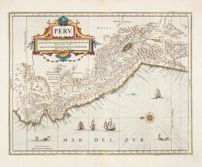
Beautiful antique map of Peru by Johannes Janssonius. Showing Peru with an eastward orientation, delineates the colony along its Pacific coast. The rugged, mountainous terrain dominates the interior, extending towards the top of the map and the decorative cartouche. The sharp peaks illustrate the challenging landscape of the area.
The rivers, marked on the map, guide us to various settlements denoted by small buildings or dots, reflecting their sizes. Lake Titicaca takes a prominent position, featuring several islands within its boundaries. At sea, three sailing ships underscore Peru's vital role in commerce and trade, while two sea monsters serve as a nod to the Pacific Ocean's inherent perils. In the upper left corner, a visually striking strapwork cartouche with delicate floral patterns surrounding the simple. This map not only offers geographical insights but also captures the artistic embellishments of the Dutch Golden Age.
From the French edition of the Mercator-Hondius Atlas printed in 1633.
Details
| Cartographer | Johannes Janssonius |
| Title | Peru |
| Publisher, Year | Janssonius, Amsterdam, 1633 |
| Plate Size | 37.8 x 48.5 cm (14.9 x 19.1 inches) |
| Sheet Size | 48.0 x 56.6 cm (18.9 x 22.3 inches) |
| Reference | Van der Krogt, P.: Koeman's Atlantes Neerlandici, 9820:1. |
Condition
Cartographer
Images to Download
If you like to download the image of this map with a resolution of 1200 pixels, please follow the link below.
You can use this image for publication on your personal or commercial websites for free if you set a link to this website. If you need photographs with a higher resolution, please contact us.

![[West Indies, Jamaica, Hispaniola and South America] [West Indies, Jamaica, Hispaniola and South America]](https://www.vintage-maps.com/3035-home_default/bordone-central-america-caribbean-jamaica-hispaniola.jpg)
