Product successfully added to your shopping cart
There are 0 items in your cart. There is 1 item in your cart.
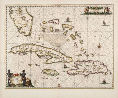
Insularum Hispaniolae et Cubae, Cum Insulis circumjacentibus accurata delineatio.
Johannes Janssonius (*1588 - †1664)Reference 11917
Description
First Edition of Jansson's map of Southern Florida and the Western Caribbean
Rare and very decorative, old coloured sea chart of Southern Florida and the Western Caribbean by J. Janssonius. Shows the southern tip of Florida, the Bahamas and the Greater Antilles with Cuba, Hispaniola (Haiti and the Dominican Republic) and Jamaica. Decorated with rhumb lines, two compass roses, sailing ships, a title cartouche and a mileage scale.
From the first real sea atlas, known as the Atlas Maritimus. This map comes from the German edition Das Fünffte Theil Des Grossen Atlantis, Welches begreiffet Die Wasser-Welt, Das ist: Eine sehr kunstreiche Abbildung und Beschreibung aller Wasser und Meeren... by Johannes Janssonius (J. Jansson), published as the fifth volume of his Atlas Novus in Amsterdam in 1650.
Philip D. Burden in The Mapping of North America about this map:
For this atlas three new charts relating to North America were produced. This one, produced in a larger scale than usual, reflected the importance of its waters to Spain. It was through the Canaal van Bahama that a large portion of the gold and silver from the americas passed. Cartographically the map is drawn from the extremely rare Hessel Gerritsz chart of c. 1631. The nomenclature of the Florida peninsula matches, with the exception of five names at the southern tip. The most interesting feature is the reintroduction of a mountain range; this had not been seen on a map of the region since those of de Bry in the 1590s. After a brief period where the name Tegesta was applied, FLORIDA is used again.
Details
| Cartographer | Johannes Janssonius |
| Title | Insularum Hispaniolae et Cubae, Cum Insulis circumjacentibus accurata delineatio. |
| Publisher, Year | Johannes Janssonius, Amsterdam, 1650 |
| Plate Size | 41.4 x 53.1 cm (16.3 x 20.9 inches) |
| Sheet Size | 50.0 x 58.7 cm (19.7 x 23.1 inches) |
| Reference | Burden, P.D.: The Mapping of North America No. 291 first state; Van der Krogt, P.: Koeman's Atlantes Neerlandici, 9610:1B |
Condition
Cartographer
Images to Download
If you like to download the image of this map with a resolution of 1200 pixels, please follow the link below.
You can use this image for publication on your personal or commercial websites for free if you set a link to this website. If you need photographs with a higher resolution, please contact us.
Atlantic Ocean - Janssonius, Johannes - Insularum Hispaniolae et Cubae, Cum...

![[Manuscript Chart of the South Atlantic Ocean] Tweede stuck wassende Graedkaert van de Kaap Verdische Eilanden tot de Kaap [Manuscript Chart of the South Atlantic Ocean] Tweede stuck wassende Graedkaert van de Kaap Verdische Eilanden tot de Kaap](https://www.vintage-maps.com/3745-home_default/blaeu-manuscript-1690.jpg)

![[Canary Islands] [Canary Islands]](https://www.vintage-maps.com/3021-home_default/bordone-spain-portugal-canaries-tenerife-gran-canaria.jpg)
![[Porto Santo and Madeira] [Porto Santo and Madeira]](https://www.vintage-maps.com/3025-home_default/bordone-spain-portugal-porto-santo-madeira-1528-1565.jpg)
