Product successfully added to your shopping cart
There are 0 items in your cart. There is 1 item in your cart.
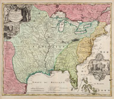
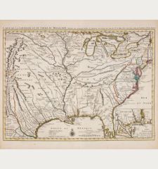
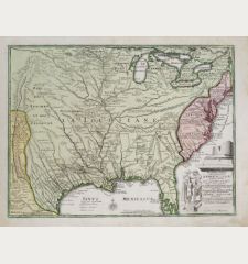
Amplissimae Regionis Mississipi seu Provinciae Ludovicianae a R.P. Ludovico Hennepin...
Johann Baptist Homann (*1664 - †1724)Reference 11485
Description
The famous Buffalo Map of the Southeast by J.B. Homann. Showing the most part of today United States from the Great Lakes to Florida, the Mississippi River Valley with Louisiana and Texas, as well as New Mexico in the west.
The map is based on the de l'Isle map of 1718. Homann dedicated it to the Franciscan Father Antoine Hennepin who explored the Mississippi and Great Lakes regions and the Niagara Falls. The magnificent title cartouche is showing the Franciscan, with a view of the Niagara falls below. The cartouche right to Florida showing American Indians with a buffalo and a pelican.
The original coloring was done in Homann's publishing company and indicates the political situation in the early 1700's. The English Colonies are colored yellow, New Mexico and Canada in red, the Mississippi River Valley with Louisiana up to the Great Lakes in turquois and Florida is covered with green.
Details
| Cartographer | Johann Baptist Homann |
| Title | Amplissimae Regionis Mississipi seu Provinciae Ludovicianae a R.P. Ludovico Hennepin Francisc Miss in America Septentrionali Anno 1687. Detectae, Nunc Gallorum Coloniis et Actionum Negotiis Toto Orbe Celeberrimae ... |
| Publisher, Year | J.B. Homann, Nuremberg, circa 1720 |
| Plate Size | 48.6 x 57.4 cm (19.1 x 22.6 inches) |
| Sheet Size | 52.2 x 60.5 cm (20.6 x 23.8 inches) |
| Reference | Cumming, W.P.: The Southeast in Early Maps, No. 170; Goos, J.: The Mapping of North America, No. 49.; Sandler, C.: Johann Baptista Homann, Die Homännischen Erben, Matthäus Seutter und Ihre Landkarten, p. 60, No. 145. |
Condition
Cartographer
Images to Download
If you like to download the image of this map with a resolution of 1200 pixels, please follow the link below.
You can use this image for publication on your personal or commercial websites for free if you set a link to this website. If you need photographs with a higher resolution, please contact us.
North America - Homann, Johann Baptist - Amplissimae Regionis Mississipi seu...

