Product successfully added to your shopping cart
There are 0 items in your cart. There is 1 item in your cart.
Total products
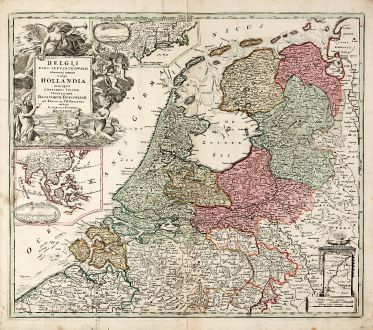
Belgii Pars Septentrionalis Communi Nomine vulgo Hollandia ... / Batavorum Coloniae...
Johann Baptist Homann (*1664 - †1724)Old coloured map of Jakarta, New York. Printed in Nuremberg by J. B. Homann circa 1710.
Reference 11146
Description
Original old coloured map of the Low Countries by JB Homann. With large inset maps of the Northeastern US from the Chesapeake to Massachusetts and Southeast Asia and additional vignette views of New Amsterdam (New York) and Batavia (Jakarta). A very detailed map of the Low Countries, celebrating the Dutch Colonial controls over the northeastern US with New York and Southeast Asia. Decorated with a large allegorical cartouche. The only map of Homann with a city view of New York.
Details
| Cartographer | Johann Baptist Homann |
| Title | Belgii Pars Septentrionalis Communi Nomine vulgo Hollandia ... / Batavorum Coloniae Occidential Indiis Septentrionalis Americae implantate / India Orientalis Batavorum Commerciis, Potentia & Coloniis celeberrima. / Batavia / Niew Amsterdam. |
| Publisher, Year | J. B. Homann, Nuremberg, circa 1710 |
| Plate Size | 48.2 x 56.5 cm (19.0 x 22.2 inches) |
| Sheet Size | 52.7 x 61.0 cm (20.7 x 24.0 inches) |
Condition
Slightly wrinkled from printing process in upper left half, some soiling mainly in margin, lower right margin and left corner backed.
Cartographer
Johann Baptist Homann was born 1664 in Oberkammlach. He founded his business 1702 in Nuremberg, Germany. After a long period of Dutch domination in map publishing, the Homann publishing house became the most important map and atlas producer in Germany. He became a member of the Academy of Science in Berlin just after he published his first atlas in 1707. After his death 1724 in Nuremberg, the company was continued by his son Johann Christoph. The publishing firm was bequeathed to his heirs after his death in 1730 and was traded under the name Homann Heirs until the next century.
Images to Download
If you like to download the image of this map with a resolution of 1200 pixels, please follow the link below.
You can use this image for publication on your personal or commercial websites for free if you set a link to this website. If you need photographs with a higher resolution, please contact us.
Johann Baptist Homann: Belgii Pars Septentrionalis Communi Nomine vulgo Hollandia ... / Batavorum Coloniae Occidential Indiis Septentrionalis....
Old coloured map of Jakarta, New York. Printed in Nuremberg by J. B. Homann circa 1710.
Netherlands - Homann, Johann Baptist - Belgii Pars Septentrionalis Communi Nomine...

![[Aa-Berlicum-Erp] [Aa-Berlicum-Erp]](https://www.vintage-maps.com/2588-home_default/anonymous-netherlands-river-aa-1780.jpg)
![[Kleve, Duisburg, Emmerich, Gennep] Cliviam, Ducatus Clivensis - Duisburgum - Embrica, Clivensis ditionis - Gennapium... [Kleve, Duisburg, Emmerich, Gennep] Cliviam, Ducatus Clivensis - Duisburgum - Embrica, Clivensis ditionis - Gennapium...](https://www.vintage-maps.com/3818-home_default/braun-hogenberg-north-rhine-westphalia-emmerich-duisburg-kleve.jpg)

![[Amsterdam] [Amsterdam]](https://www.vintage-maps.com/1930-home_default/muenster-netherlands-amsterdam-1574.jpg)
