Product successfully added to your shopping cart
There are 0 items in your cart. There is 1 item in your cart.
Total products
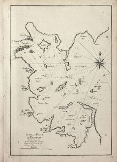
Baye et Port de Boston. Tire des Manuscrits de M. le Chevalier de la Rigaudiere...
George Louis le Rouge (*1707 - †1790)Sea chart of Boston. Printed in Paris by le Rouge in 1756.
Reference 10976
Description
Unrecorded and exceptional rare chart of the Bay around Boston during the French & Indian War
An unrecorded sea chart of Boston by G. L. le Rouge during the French & Indian War, which is not listed in any of the standard references on the mapping of Boston. Based upon the manuscript maps taken from the voyage of lieutenant commander Rigaudiere at the beginning of the French & Indian War. The chart extends from Nahant Bay and Charles Town to Hingam, Meneticu and Beacon Hill. It includes lovely town illustrations of Boston, Charles Town, Dorchester, Bantrey, Milton, Meneticu and Hingam, along with several unnamed towns. It also shows detailed soundings and anchorages in Boston Harbor and an illustration of a sailing ship anchored off Boston.
Only a few examples of this separately issued chart are known. One is in the Boston Public Library another in Yale and two in private American ownership.
Details
| Cartographer | George Louis le Rouge |
| Title | Baye et Port de Boston. Tire des Manuscrits de M. le Chevalier de la Rigaudiere Lieutenant de Vaissau du Roy . A Paris par le Rouge. Rue des Augustins. |
| Publisher, Year | le Rouge, Paris, 1756 |
| Plate Size | 47.5 x 32.2 cm (18.7 x 12.7 inches) |
| Sheet Size | 53.0 x 38.0 cm (20.9 x 15.0 inches) |
Condition
Strong and clear impression on excellent paper. Small binding holes in left wide margin. Perfect condition. It is quite unusual to find a separate published map in such preservation.
Cartographer
G. L. le Rouge was a French military engineer, hydrographer and cartographer. He produced a wide rang of attractive cartographic work. He held a position of Geographical Engineer to King Louis XV.
Images to Download
If you like to download the image of this map with a resolution of 1200 pixels, please follow the link below.
You can use this image for publication on your personal or commercial websites for free if you set a link to this website. If you need photographs with a higher resolution, please contact us.
George Louis le Rouge: Baye et Port de Boston. Tire des Manuscrits de M. le Chevalier de la Rigaudiere Lieutenant de Vaissau du Roy . A Paris par....
Sea chart of Boston. Printed in Paris by le Rouge in 1756.
North America - le Rouge, George Louis - Baye et Port de Boston. Tire des...

