Product successfully added to your shopping cart
There are 0 items in your cart. There is 1 item in your cart.
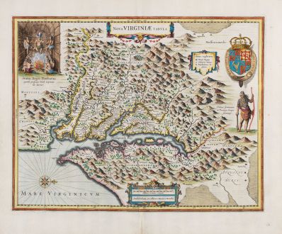
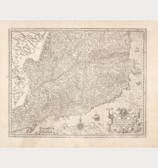
Nova Virginiae Tabula
Jodocus Hondius (*1563 - †1612)Reference 12771
Description
First State of the Hondius' derivative of John Smith's Virginia Map.
A very fine example of the first state of Henricus Hondius' derivative of John Smith's significant 1612 map of Virginia. The Chesapeake region map, engraved by Henricus for his 1630 Atlantis Appendix, stands out as one of his earliest engravings. This example comes from the early 1633 French edition, the first publication after the Appendix edition. The Hondius edition of Smith's Virginia map is the only edition where the Indian faces the Chesapeake.
John Smith's map holds immense importance and influence, as acknowledged by Burden. Considered one of the most significant printed maps of America ever published, it served as a prototype for the region for approximately fifty years. In fact, Burden asserts that the map's publication significantly impacted the success of the Virginia Colony itself.
In 1606, the London Company dispatched its inaugural ship to Virginia, establishing the Jamestown settlement, where Captain John Smith accompanied the English settlers. From 1607 to 1609, Smith embarked on explorations along the major rivers flowing west into the Chesapeake Bay, meticulously documenting the names of encountered Native American villages and tribes. The boundaries of Smith's explorations are demarcated with Maltese crosses, while he relied on Native American accounts to delineate territories further upstream. Smith's map features a note stating, To the crosses hath bin discouerd what beyond is by relation.
Smith's map is a primary source of information on the region during the early 17th century, particularly in terms of Native American villages and the region itself. Burden highlights its ongoing usefulness, noting that archaeologists still employ the map to locate native Indian villages, as it provides detailed information on 166 of them. Notably, the illustrations of Powhatan's Council and Native Americans derive from the original drawings by John White.
After Smith's return to England in 1609, he enlisted William Hole to engrave a map, initially included in a small pamphlet by Joseph Barnes of Oxford in 1612. The map resurfaced twelve years later when it appeared alongside Smith's map of New England in his significant work, The Generall Historie of Virginia, New-England and the Summer Isles in 1624. The following year, it was featured in Purchas His Pilgrimes.
Smith's map dominated as the most crucial map of Virginia in the first half of the 17th century. Initially issued in 1612, it served as the prototype for mapping the region until Augustine Hermann's map of 1673. The map documents various explorations and observations made by Smith and the Jamestown settlers. While there is some debate over whether Smith or the accompanying surveyor Nathaniel Powell created the map, convention attributes it to John Smith, as his name appears on it in two of his publications and in a third by Samuel Purchas, who credits Smith with its production.
For nearly sixty years, the map became the blueprint for mapping the region, with numerous cartographers reproducing it until the 1670s.
Details
| Cartographer | Jodocus Hondius |
| Title | Nova Virginiae Tabula |
| Publisher, Year | Henricus Hondius, Amsterdam, 1633 |
| Plate Size | 38.2 x 49.3 cm (15.0 x 19.4 inches) |
| Sheet Size | 47.7 x 56.7 cm (18.8 x 22.3 inches) |
| Reference | Van der Krogt, P.: Koeman's Atlantes Neerlandici, 9410:1; Burden, P.D.: The Mapping of North America No. 228 |
Condition
Cartographer
Images to Download
If you like to download the image of this map with a resolution of 1200 pixels, please follow the link below.
You can use this image for publication on your personal or commercial websites for free if you set a link to this website. If you need photographs with a higher resolution, please contact us.

