Product successfully added to your shopping cart
There are 0 items in your cart. There is 1 item in your cart.
Sea Charts

Residuum Continentis Cum Adiacentibus Insulis.
Louvain, circa 1597
Early and important antique map of Venezuela and the eastern part of the Caribbean by Cornelis van Wytfliet. First published in 1597 in Descriptionis Ptolemaicae Augmentum . Showing the north...
Residuum Continentis Cum Adiacentibus Insulis.
1597 - Cornelius Wytfliet
11884Antique map of Venezuela and the Caribbean. Printed in Louvain circa 1597.
820,00 €![Hondius, Central America - Caribbean, Bermuda, 1633 [1634]: Mappa Aestivarum Insularum, alias Barmudas Dictarum ... Accurate Descripta]( "Jodocus Hondius: Mappa Aestivarum Insularum, alias Barmudas Dictarum ... Accurate Descripta")
Mappa Aestivarum Insularum, alias Barmudas Dictarum ... Accurate Descripta
H. Hondius, Amsterdam, 1633 [1634]
Very decorative old coloured antique nautical chart of the Islands of Bermuda by Hendrick Hondius. Shows the Bermuda Islands with Grand Bermuda, Somerset Island and Saint George's Island. Decorated...
Mappa Aestivarum Insularum, alias Barmudas Dictarum ... Accurate Descripta
1633 - Jodocus Hondius
12424Old coloured sea chart of Bermuda. Printed in Amsterdam by H. Hondius in 1634.
1 700,00 €
Mappa Aestivarum Insularum, alias Barmudas Dictarum ... Accurate Descripta
H. Hondius, Amsterdam, 1633
First edition of the very decorative nautical chart of the Islands of Bermuda by Hendrick Hondius. Shows the Bermuda Islands with Grand Bermuda, Somerset Island and Saint George's Island. Decorated...
Mappa Aestivarum Insularum, alias Barmudas Dictarum ... Accurate Descripta
1633 - Jodocus Hondius
12770Coloured sea chart of Bermuda. Printed in Amsterdam by H. Hondius in 1633.
2 100,00 €
Venezuela, cum parte Australi Novae Andalusiae.
Henricus Hondius, Amsterdam, 1633
A fine 17th century map of Venezuela and the Lesser Antilles by Jodocus Hondius. Shows Venezuela, along with the Windward Islands (comprising Dominica, Trinidad and Tobago), as well as the Lesser...
Venezuela, cum parte Australi Novae Andalusiae.
1633 - Jodocus Hondius
12790Coloured map of Venezuela. Printed in Amsterdam by Henricus Hondius in 1633.
850,00 €
Insularum Moluccarum Nova Descriptio.
Janssonius, Amsterdam, 1633
This beautiful map shows the famed Spice Islands, crucial to the Dutch trading empire in the East Indies during the 17th Century. It shows the Indonesian archipelago of the Moluccas between...
Insularum Moluccarum Nova Descriptio.
1633 - Johannes Janssonius
12869Coloured map of Spice Islands, Indonesia, Moluccas. Printed in Amsterdam by Janssonius in 1633.
750,00 €
Accuratissima Brasiliae Tabula. Amstelodami Henricus Hondius excudit.
Henricus Hondius, Amsterdam, 1636
Antique map of Brazil by Henricus Hondius. Shows a very detailed and accurate coastline while the interior is still speculative. With two inset maps of Baya de Todos os Sanctos (Bay of All...
Accuratissima Brasiliae Tabula. Amstelodami Henricus Hondius excudit.
1636 - Jodocus Hondius
11918Coloured map of Brazil. Printed in Amsterdam by Henricus Hondius in 1636.
950,00 €
Tabula Magellanica, qua Tierrae del fuego cum celeberrimis fretis a F. Magellano et I. Le Maire...
Joan Blaeu, Amsterdam, 1643-50
Blaeu's splendid map of Tierra de Fuego with the Strait of Magellan.Old coloured sea chart of Tierra de Fuego with the Strait of Magellan and Le Maire Strait by Willem Blaeu. From the French...
Tabula Magellanica, qua Tierrae del fuego cum celeberrimis fretis a F....
1643 - Willem Janszoon Blaeu
11765Old coloured sea chart of the Strait of Magellan, Tierra del Fuego. Printed in Amsterdam by Joan Blaeu in 1643.
1 250,00 €
Pascaart, Waer in men claarlyck zien can, alle havens rivieren droogten, gelegen tusschen C.S....
Johannis Janssonius, Amsterdam, 1650
Rare and very decorative sea chart of the Atlantic coast of North Africa. Shows the coastline from southern Portugal to Gibraltar and North Africa from Morocco to Gambia. With the Canary Islands...
Pascaart, Waer in men claarlyck zien can, alle havens rivieren droogten,...
1650 - Johannes Janssonius
11864Coloured sea chart of the Atlantic Ocean. Printed in Amsterdam by Johannis Janssonius in 1650.
750,00 €
Pascaart vande Noort-Zee. Tabula Hydrographica Oceani Borealis.
Johannes Janssonius, Amsterdam, 1650
Rare and very decorative, old coloured sea chart of the North Sea by J. Janssonius. Shows the North Sea coast with the Shetland and Orkney Islands, the Scottish and English east coast, Calais and...
Pascaart vande Noort-Zee. Tabula Hydrographica Oceani Borealis.
1650 - Johannes Janssonius
11914Old coloured sea chart of the North Sea. Printed in Amsterdam by Johannes Janssonius in 1650.
1 650,00 €
Sinus Gangeticus, Vulgo Golfo De Bengala Nova descriptio.
Johannes Janssonius, Amsterdam, 1650
Rare and very decorative, old coloured sea chart of the Bay of Bengal by J. Janssonius. Shows the north-eastern part of the Indian Ocean with Sri Lanka, the east coast of India, Bangladesh,...
Sinus Gangeticus, Vulgo Golfo De Bengala Nova descriptio.
1650 - Johannes Janssonius
11915Old coloured sea chart of the Gulf of Bengal. Printed in Amsterdam by Johannes Janssonius in 1650.
850,00 €
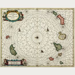
Caarte voor een gedeelte der Canarise Eylanden
Amsterdam, circa 1660
Rare sea chart of the Canary Islands by Pieter Goos. The islands featured from left to right include El Hierro, La Palma, La Gomera, Tenerife, Gran Canaria, Fuerteventura, Isla de Lobos, Lanzarote,...
Caarte voor een gedeelte der Canarise Eylanden
1660 - Pieter Goos
12943Old coloured sea chart of the Canary Islands. Printed in Amsterdam circa 1660.
1 350,00 €
De Cust van Engelandt tuschen Welles en t'Eylandt Coket
Amsterdam, circa 1676
Rare sea chart of the east coast of England by Pieter Goos. Showing the east coast of Norfolk, Yorkshire and Durham with Boston, Kingston Upon Hull, Bridlington, Scarborough, Whitby and Newcastle...
De Cust van Engelandt tuschen Welles en t'Eylandt Coket
1676 - Pieter Goos
12049Coloured sea chart of Norfolk, Yorkshire, North Sea, England. Printed in Amsterdam circa 1676.
590,00 €
Pascaert vande Zuyd Zee en een Gedeelte van Brasil Van Ilhas de Ladronos tot R. de la Plata
J. van Keulen, Amsterdam, 1680
Dramatic Sea Chart of the Pacific with California Depicted as an Island. Johannes van Keulen's very decorative chart of the Pacific Ocean. Shows the Pacific Ocean with North and South America....
Pascaert vande Zuyd Zee en een Gedeelte van Brasil Van Ilhas de Ladronos...
1680 - Johannes van Keulen
12737Coloured sea chart of the Pacific Ocean. Printed in Amsterdam by J. van Keulen in 1680.
7 900,00 €![Blaeu, Manuscript, 1690: [Manuscript Chart of the South Atlantic Ocean] Tweede stuck wassende Graedkaert van de Kaap Verdische Eilanden tot de Kaap]( "Willem Janszoon Blaeu: [Manuscript Chart of the South Atlantic Ocean] Tweede stuck wassende Graedkaert van de Kaap Verdische Eilanden tot de Kaap")
[Manuscript Chart of the South Atlantic Ocean] Tweede stuck wassende Graedkaert van de Kaap...
Joan Blaeu II, Amsterdam, circa 1690
A Dutch East India Company (V.O.C.) Manuscript Chart by Joan Blaeu II on VellumFragment of a manuscript nautical chart of the Dutch East India Company (VOC) of the West African coast by Joan...
[Manuscript Chart of the South Atlantic Ocean] Tweede stuck wassende...
1690 - Willem Janszoon Blaeu
12620Manuscript sea chart on vellum of the Atlantic Ocean with the West African coast line. Drawn by Joan Blaeu II in Amsterdam.
14 800,00 €
Insulae Canariae, olim Fortunatae Dictae
Valk & Schenk, Amsterdam, circa 1690
Very decorative nautical chart of the Canary Islands by J. Janssonius. Shows Fuerteventura, Lanzarote, Tenerife, Gran Canaria, La Gomera, La Palma and Madeira. With beautiful old color. Decorated...
Insulae Canariae, olim Fortunatae Dictae
1690 - Johannes Janssonius
12760Old coloured sea chart of the Canary Islands with Madeira. Published by Valk & Schenk in Amsterdam around 1690.
890,00 €
Insula Borneo et occidentalis pars Celebis cum adiacentibus Insulis
Valk & Schenk, Amsterdam, circa 1690
Rare and very decorative old colored sea chart of Borneo by J. Janssonius. Shows the island belonging to Indonesia, Malaysia and Brunei in the Malay Archipelago. West oriented sea chart. Decorated...
Insula Borneo et occidentalis pars Celebis cum adiacentibus Insulis
1690 - Johannes Janssonius
12761Sea chart of Borneo, Malaysia, Indonesia. Printed in Amsterdam by Valk & Schenk circa 1690.
800,00 €
Fowey & Mounts-Bay ...
Freeman Collins, London, 1693-1792
Decorative antique sea chart of the coast of Cornwell, the southwestern part of England. Shows the coastline from Polkerris to Pencarrah Head with Fowey and Polruan. The inset to the upper left...
Fowey & Mounts-Bay ...
1693 - Greenville Collins
11780Coloured sea chart of Fowey, Mount's Bay, Cornwall, England. Printed in London between 1693 and 1792.
420,00 €![Collins, Scotland, North Sea, Moray Firth, Inverness: [The Firth of Murry] - To the Rt Hon.ble, my Lord Viscount Torbat, Lord Register of the Kingdom of Scotland]( "Greenville Collins: [The Firth of Murry] - To the Rt Hon.ble, my Lord Viscount Torbat, Lord Register of the Kingdom of Scotland")
[The Firth of Murry] - To the Rt Hon.ble, my Lord Viscount Torbat, Lord Register of the Kingdom...
Freeman Collins, London, 1693-1792
Decorative antique sea chart of the Moray Firth on the north coast of Scotland. Shows the coastline from Helmsdale to Burghead with the Tarbet Bay and the Cromarty Firth, Inverness, Fortrose and...
[The Firth of Murry] - To the Rt Hon.ble, my Lord Viscount Torbat, Lord...
1693 - Greenville Collins
11783Antique sea chart of Moray Firth with Inverness, Scotland. Printed in London between 1693 and 1792.
380,00 €
Yarmouth and the Sands about it
Freeman Collins, London, 1693-1792
Decorative antique sea chart of Great Yarmouth on the east coast of England. Shows the coastline from Lowestoft to Winterton-on-Sea with Great Yarmouth, Corton, Gorleston-on-Sea and Caister-on-Sea....
Yarmouth and the Sands about it
1693 - Greenville Collins
11784Coloured sea chart of Great Yarmouth, Norfolk, England. Printed in London by Freeman Collins between 1693 and 1792.
380,00 €
The River Humber - Is most Humbly Dedicated and Presented To the Worshipll. Corporation of...
Freeman Collins, London, 1693-1792
Decorative antique sea chart of the Humber estuary with parts of Yorkshire and Lincolnshire at the east coast of England. It shows the Humber from Barton, Kingston-upon-Hull, Paull, Grimsby up to...
The River Humber - Is most Humbly Dedicated and Presented To the...
1693 - Greenville Collins
11785Coloured sea chart of Humber, Lincolnshire, Yorkshire, England. Printed in London by Freeman Collins between 1693 and 1792.
380,00 €
Harwich, Woodbridg and Handfordwater, with the Sands from the Nazeland and to Hosely Bay.
Freeman Collins, London, 1693-1792
Decorative antique sea chart of Harwich, Essex on the east coast of England. Shows the coastline from Hollesley to Walton-on-the-Naze with Shotley Gate, Felixstowe, Bawdsey and the estuaries of...
Harwich, Woodbridg and Handfordwater, with the Sands from the Nazeland...
1693 - Greenville Collins
11786Coloured sea chart of Harwich, Essex, England. Printed in London by Freeman Collins between 1693 and 1792.
520,00 €
Milford-Haven - To His Grace Henry Duke of Beaufort, and Earle of Worcester, Baron Herbert of...
Freeman Collins, London, 1693-1792
Decorative antique sea chart of Milford Haven in Wales. Shows the natural harbour Milford Haven Waterway formed by the Pembroke River and the Daugleddau estuary. With many place names, including...
Milford-Haven - To His Grace Henry Duke of Beaufort, and Earle of...
1693 - Greenville Collins
11788Coloured sea chart of Milford Haven, Pembrokeshire, Wales. Printed in London by Freeman Collins between 1693 and 1792.
490,00 €
Plymouth - To The Rt. Honble. Arthur Earle Of Torrington, Baron Herbert of Torbay.
Freeman Collins, London, 1693-1792
Decorative antique nautical chart of the Plymouth Sound in southwest England. Shows the bay from the Rame Church to Newton Ferrers. In addition to Plymouth numerous places are mentioned,...
Plymouth - To The Rt. Honble. Arthur Earle Of Torrington, Baron Herbert...
1693 - Greenville Collins
11789Coloured sea chart of Plymouth, Devonshire, England. Printed in London by Freeman Collins between 1693 and 1792.
490,00 €
Isole Canarie
Venice, 1696
Large antique sea chart of the Canary Islands and Madeira by V. M. Coronelli. The detailed map shows the Canary Islands with Fuerteventura, Lanzarote, Tenerife, Gran Canaria, La Gomera and La...
Isole Canarie
1696 - Vincenzo Maria Coronelli
12574Coloured map of Madeira and the Canary Islands. Printed in Venice in the year 1696.
750,00 €

![Hondius, Central America - Caribbean, Bermuda, 1633 [1634]: Mappa Aestivarum Insularum, alias Barmudas Dictarum ... Accurate Descripta](https://www.vintage-maps.com/3690-home_default/hondius-central-america-caribbean-bermuda-1633-1634.jpg "Jodocus Hondius: Mappa Aestivarum Insularum, alias Barmudas Dictarum ... Accurate Descripta")


![Blaeu, Manuscript, 1690: [Manuscript Chart of the South Atlantic Ocean] Tweede stuck wassende Graedkaert van de Kaap Verdische Eilanden tot de Kaap](https://www.vintage-maps.com/3745-home_default/blaeu-manuscript-1690.jpg "Willem Janszoon Blaeu: [Manuscript Chart of the South Atlantic Ocean] Tweede stuck wassende Graedkaert van de Kaap Verdische Eilanden tot de Kaap")


![Collins, Scotland, North Sea, Moray Firth, Inverness: [The Firth of Murry] - To the Rt Hon.ble, my Lord Viscount Torbat, Lord Register of the Kingdom of Scotland](https://www.vintage-maps.com/2244-home_default/collins-scotland-north-sea-moray-firth-inverness.jpg "Greenville Collins: [The Firth of Murry] - To the Rt Hon.ble, my Lord Viscount Torbat, Lord Register of the Kingdom of Scotland")


