Product successfully added to your shopping cart
There are 0 items in your cart. There is 1 item in your cart.
Sea Charts

Pascaart vant Canaal tusschen Engelant en Vrancryck, alsmede geheel Ierlant en Schotlant ......
Johannis Janssonius, Amsterdam, circa 1650
Rare and very decorative sea chart of the coastal waters of the British Isles and the English Channel. Oriented to the west. Beautified with rhumb lines and two compass roses. The beautiful title...
Pascaart vant Canaal tusschen Engelant en Vrancryck, alsmede geheel...
1650 - Johannes Janssonius
11764Old coloured sea chart of the British Isles. Printed in Amsterdam by Johannis Janssonius circa 1650.
Sold![Janssonius, Mediterranean, 1650: Pascaarte Van't Westlyckste deel vande Middelandsche Zee [&] Pascaarte Van't Oostelyckste deel vande Middelandsche Zee]( "Johannes Janssonius: Pascaarte Van't Westlyckste deel vande Middelandsche Zee [&] Pascaarte Van't Oostelyckste deel vande Middelandsche Zee")
Pascaarte Van't Westlyckste deel vande Middelandsche Zee [&] Pascaarte Van't Oostelyckste deel...
Johannes Janssonius, Amsterdam, 1650
Two rare and very decorative nautical charts of the entire Mediterranean area. The western and eastern part of the Mediterranean printed on two sheets. The seachart of the western part shows the...
Pascaarte Van't Westlyckste deel vande Middelandsche Zee [&] Pascaarte...
1650 - Johannes Janssonius
11869Old coloured sea chart of the Mediterranean Sea. Printed in Amsterdam by Johannes Janssonius in 1650.
Sold
Insulae de Cabo Verde Olim Hesperides sive Gorgades: Belgice De Zoute Eylanden.
Johannes Janssonius, Amsterdam, 1650
Rare and decorative, old coloured sea chart of the Cape Verde Islands by J. Janssonius. Showing Cape Verde (Cabo Verde) with the islands Santo Antão, São Vicente, Santa Luzia, São Nicolau, Sal, Boa...
Insulae de Cabo Verde Olim Hesperides sive Gorgades: Belgice De Zoute...
1650 - Johannes Janssonius
11916Old coloured sea chart of Cabo Verde, Cape Verde Islands. Printed in Amsterdam by Johannes Janssonius in 1650.
Sold
Insularum Hispaniolae et Cubae, Cum Insulis circumjacentibus accurata delineatio.
Johannes Janssonius, Amsterdam, 1650
First Edition of Jansson's map of Southern Florida and the Western Caribbean Rare and very decorative, old coloured sea chart of Southern Florida and the Western Caribbean by J. Janssonius....
Insularum Hispaniolae et Cubae, Cum Insulis circumjacentibus accurata...
1650 - Johannes Janssonius
11917Old coloured sea chart of Florida and Western Caribbean. Printed in Amsterdam by Johannes Janssonius in 1650.
Sold
Nova et Accurata Poli Arctici et Terrarum Circum Iacentium Descriptio
Johannes Janssonius, Amsterdam, 1650
Old colored sea chart of the North Pole by J. Janssonius. With Greenland and Canada, Iceland, Spitsbergen, Norway and the north coast of Russia. The map shows, the famous Northwest Passage , a...
Nova et Accurata Poli Arctici et Terrarum Circum Iacentium Descriptio
1650 - Johannes Janssonius
11920Old coloured sea chart of the North Pole. Printed in Amsterdam by Johannes Janssonius in 1650.
Sold
De Cust van Barbaria, Gualata, Arguyn en Geneheo van Capo S. Vincent tot Capo Verde
Hendrick Doncker, Amsterdam, circa 1660
Detailed sea chart of the Iberian Peninsula and the northwest coast of Africa. Shows the coastline with the Canary Islands, Madeira and Cape Verde Islands. Beautified with a decorative cartouche...
De Cust van Barbaria, Gualata, Arguyn en Geneheo van Capo S. Vincent tot...
1660 - Hendrick Doncker
11299Coloured sea chart of the Canary Island, Atlantic, North Africa. Printed in Amsterdam by Hendrick Doncker circa 1660.
Sold
Insulae Acores Delineante Ludovico Teisera
Joan Blaeu, Amsterdam, 1662
Highly decorative sea chart of the Azores Islands. At the upper left the northwestern islands of Corvo and Flores, in the middle the central archipelago with Faial, Pico, São Jorge, Graciosa and...
Insulae Acores Delineante Ludovico Teisera
1662 - Willem Janszoon Blaeu
11775Old coloured sea chart of the Azores Islands. Published by Joan Blaeu in Amsterdam in 1662.
Sold
Pas-Caart van Guinea en de Custen daer aen gelegen Van Cabo verde tot Cabo de Bona Esperanca
Amsterdam, 1666
Beautiful sea chart of the southwest coast of Africa by P. Goos from the famous sea atlas "De Zee-Atlas ofte Water-Weereld". Showing the coatlines of Guinea, Sierra Leone, Liberia, Ivory Coast via...
Pas-Caart van Guinea en de Custen daer aen gelegen Van Cabo verde tot...
1666 - Pieter Goos
10411Sea chart of the southwest coast of Africa by Pieter Goos. Published in Amsterdam in 1666.
Sold
Paskaerte van't Oostelyckste der Middelandsche Zee
Pieter Goos, Amsterdam, 1666
Rare, highly decorative sea chart of the Eastern Mediterranean. With Sicily, Malta, Crete and Cyprus. From the sea atlas De Zee-Atlas, Ofte Water-Weereld, Waer in vertoont werden alle de...
Paskaerte van't Oostelyckste der Middelandsche Zee
1666 - Pieter Goos
11300Old coloured sea chart of the eastern Mediterranean. Printed in Amsterdam by Pieter Goos in 1666.
Sold
Nova et Accurata Poli Arctici et terrarum Circum Iacentium Descriptio
Janssonius Heirs, Amsterdam, 1666
Old colored sea chart of the North Pole by J. Janssonius. With Greenland and Canada, Iceland, Spitsbergen, Norway and the north coast of Russia. The map shows, the famous Northwest Passage , a...
Nova et Accurata Poli Arctici et terrarum Circum Iacentium Descriptio
1666 - Johannes Janssonius
12042Old coloured sea chart of the North Pole. Printed in Amsterdam by Janssonius Heirs in 1666.
Sold
Brasilia
Jacob Meurs, Amsterdam, 1671
Hand-coloured engraved sea chart of Brazil by A. Montanus. From De Nieuwe en onbekende weereld: of Beschryving van America en 't zuid-land published 1671 in Amsterdam. Decorated with two...
Brasilia
1671 - Arnoldus Montanus
11449Coloured map of Brazil. Printed in Amsterdam by Jacob Meurs in 1671.
Sold
A Chart of Guinea. Describing the Sea Coast from Cape de Verde to Cape de Bona Espransa
John Seller, London, 1677-79
Very rare sea chart of West Africa by John Seller. This beautiful sea chart shows the coast of Africa from Senegal, Cape Verde, along the West African coast to the Gulf of Guinea, across the coasts...
A Chart of Guinea. Describing the Sea Coast from Cape de Verde to Cape...
1677 - John Seller
11907Sea chart of Guinea. Printed in London by John Seller in 1677.
Sold
Paskaart van de West Cust van Yrlandt beginnnende van Klady tot aen de Blasques ...
Hendrick Doncker, Amsterdam, 1681
Sea chart of the west coast of Ireland by Johannes van Keulen. Shows the coastline from the Aran Islands to the Great Blasket Islands. Beautified with two decorative cartouches, sailing ships and...
Paskaart van de West Cust van Yrlandt beginnnende van Klady tot aen de...
1681 - Johannes van Keulen
11749Coloured sea chart of the west coast of Ireland. Printed in Amsterdam by Hendrick Doncker in 1681.
Sold
The Western Ocean By Jer Seller and Cha Price
Jeremiah Seller & Charles Price, London, 1686 (1710)
A very rare sea chart of the Atlantic by John Seller. Includes almost all of South America as well as large parts of North America, Africa and Southern Europe. The map is based on the four-sheet...
The Western Ocean By Jer Seller and Cha Price
1686 - John Seller
11906Coloured sea chart of the Atlantic Ocean. Printed in London by Jeremiah Seller & Charles Price in 1710.
Sold
Falmount
Freeman Collins, London, 1693-1792
Decorative antique sea chart of the Falmouth River in Cornwall, the southwestern part of England. Shows the Falmouth Bay and the river from the mouth with Falmouth, Pendennis Castle, Penryn, St...
Falmount
1693 - Greenville Collins
11781Coloured sea chart of the Falmouth River and Helford River, Cornwall, England. Printed in London between 1693 and 1792.
Sold
Prospect of Leith from the east - To the Right Honourable Sr. James Fleming, Lord Provost of ye...
Freeman Collins, London, 1693-1792
Decorative antique nautical chart of the coast of Leith, Edinburgh, Scotland. Shows the coastline with a detailed plan of Leith. The bridge, which was built in the 15th century and demolished in...
Prospect of Leith from the east - To the Right Honourable Sr. James...
1693 - Greenville Collins
11782Antique nautical sea chart of Leith, Edinburgh, Scotland. Printed in London between 1693 and 1792.
Sold
This Chart of Kingsale Harbour...
Freeman Collins, London, 1693-1792
Decorative antique sea chart of Kinsale in County Cork, Ireland. Shows the coastline from the lighthouse at the Old Head of Kinsale to Ballymacus. Kinsale Harbour at the mouth of the River Bandon...
This Chart of Kingsale Harbour...
1693 - Greenville Collins
11787Coloured sea chart of Kingsale Harbour, County Cork. Printed in London by Freeman Collins between 1693 and 1792.
Sold
To the Honourable Sir Ralph Delavalk Vice Admirall of the Red...
Freeman Collins, London, 1693-1792
Decorative antique sea chart of the North Sea by Captain Greenville Collins. Showing the east coast of England from Dover to Edinburgh. In the southeast the coastline of Belgium and the Netherlands...
To the Honourable Sir Ralph Delavalk Vice Admirall of the Red...
1693 - Greenville Collins
12048Coloured sea chart of the North Sea, England. Printed in London by Freeman Collins between 1693 and 1792.
Sold
Burlington Bay, Scarbrough & Hartlepoole
Freeman Collins, London, 1693-1792
Decorative sea chart of Yorkshire and Durham by Captain Greenville Collins. Three sea charts on one sheet. Above the coastline with Bridlington and Hornsea, below left Hartlepool and right...
Burlington Bay, Scarbrough & Hartlepoole
1693 - Greenville Collins
12050Sea chart of Durham, Yorkshire, England. Printed in London by Freeman Collins between 1693 and 1792.
Sold
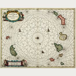
Insulae Canariae, olim Fortunatae Dictae
Valk & Schenk, Amsterdam, circa 1700
Highly decorative sea chart of the Canary Islands. Showing Fuerteventura, Lanzarote, Tenerife, Gran Canaria, La Gomera, La Palma and Madeira. Beautified with rhumb lines, compass rose and sailing...
Insulae Canariae, olim Fortunatae Dictae
1700 - Valk & Schenk
11302Old coloured sea chart of the Canary Islands with Madeira. Published by Valk & Schenk in Amsterdam around 1700.
Sold
Carte de la Mer d'Allemagne ... depuis Bergen et les Isles Schetland jusques au Pas de Calais
Pierre Mortier, Amsterdam, circa 1700
Very large sea chart of the North Sea by J. Covens and P. Mortier. Showing the coast of the North Sea with the Shetland and Orkney Islands, the Scottish and English east coast, Calais and Dover,...
Carte de la Mer d'Allemagne ... depuis Bergen et les Isles Schetland...
1700 - Covens and Mortier
12057Coloured sea chart of the North Sea. Printed in Amsterdam by Pierre Mortier circa 1700.
Sold
Paskaart van het Zuyderdeel van de Noord Zee streckende van de Wester Eems tot aan de Hoofde......
Johannes Loots, Amsterdam, circa 1700
Very rare nautical chart of the North Sea by Johannes Loots. With the coasts of Friesland, Holland, Zeeland, Flanders and the coastal regions of England with Norfolk, Suffolk, Essex and Kent with...
Paskaart van het Zuyderdeel van de Noord Zee streckende van de Wester...
1700 - Johannes Loots
12614Sea chart of the North Sea. Printed in Amsterdam by Johannes Loots circa 1700.
Sold
Nieuwe verbeterde Pascaart Beginnende van het Canaal en so Langs de kusten van Spanjen, en...
Johannes Loots, Amsterdam, circa 1700
Very rare nautical chart of the north-eastern Atlantic by Johannes Loots. Shows the coastline from Southern Ireland, Cornwall, Brittany, Spain, Portugal and the northwest coast of Africa to Cape...
Nieuwe verbeterde Pascaart Beginnende van het Canaal en so Langs de...
1700 - Johannes Loots
12616Sea chart of the Atlantic Ocean. Printed in Amsterdam by Johannes Loots circa 1700.
Sold
Paskaerte van de Bocht van Vranckrijck, Biscajen en Galissen.
Johannes Loots, Amsterdam, circa 1700
Rare sea chart of the Bay of Biscay by Johannes Loots. Shows the gulf of the northeast Atlantic Ocean (Golfe de Gascogne) from Galicia to Brittany along the north coast of Spain and the west coast...
Paskaerte van de Bocht van Vranckrijck, Biscajen en Galissen.
1700 - Johannes Loots
12617Sea chart of the Bay of Biscay. Printed in Amsterdam by Johannes Loots circa 1700.
Sold

![Janssonius, Mediterranean, 1650: Pascaarte Van't Westlyckste deel vande Middelandsche Zee [&] Pascaarte Van't Oostelyckste deel vande Middelandsche Zee](https://www.vintage-maps.com/2369-home_default/janssonius-mediterranean-1650.jpg "Johannes Janssonius: Pascaarte Van't Westlyckste deel vande Middelandsche Zee [&] Pascaarte Van't Oostelyckste deel vande Middelandsche Zee")


