Product successfully added to your shopping cart
There are 0 items in your cart. There is 1 item in your cart.

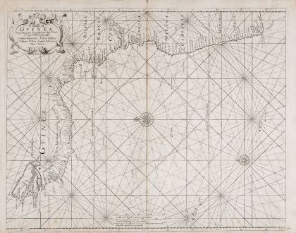
A Chart of Guinea. Describing the Sea Coast from Cape de Verde to Cape de Bona Espransa
John Seller (*1632 - †1697)Reference 11907
Description
Very rare sea chart of West Africa by John Seller. This beautiful sea chart shows the coast of Africa from Senegal, Cape Verde, along the West African coast to the Gulf of Guinea, across the coasts of Angola and Namibia to the Cape of Good Hope. East is shown on top. Top left a title cartouche, in the seas two compass roses surrounded by loxodromes.
This is the first version of the map during the cooperation of Seller, Thornton, Fisher, Colson and Atkinson in the years 1677-79. There exists another map, most probably a copy of this map, with many changes and a new cartouche with the title A Chart of the Coast of Guinea.
Details
| Cartographer | John Seller |
| Title | A Chart of Guinea. Describing the Sea Coast from Cape de Verde to Cape de Bona Espransa |
| Publisher, Year | John Seller, London, 1677-79 |
| Plate Size | 43.0 x 54.0 cm (16.9 x 21.3 inches) |
| Sheet Size | 45.5 x 58.0 cm (17.9 x 22.8 inches) |
Condition
Cartographer
John Seller was an English map and chart maker, a map and chart seller and an instrument maker. He published maps, atlases, almanacs and astronomical charts, as well as the first significant practical manuals for sailors. In March 1671 he was appointed Hydrographer of the King. Seller had a son Jeremiah, occasionally also John jr., who had learned from him and also worked as a cartographer, publisher and map maker in a collaboration with Charles Price.
The trade in nautical charts was dominated by the Dutch until the second half of the 17th century. Seller often used Dutch nautical charts and replaced the original title with an English one. Between 1671 and 1675 Seller published the first four books of The English Pilot. During the fifth book in 1677 he ran into financial difficulties and entered into a partnership with John Thornton, William Fisher, John Colson and James Atkinson. But this partnership was short-lived and the consortium took over most of Seller's map business. The English Pilot was very popular and appeared in many editions until the end of the 18th century. Around 1700 it was published by Thornton and Fisher, after Thornton's death in 1708 his son Samuel took over the business. But he died shortly after, and the stock was acquired by Mount and Page.
John Seller's most important atlases appeared in London with the following titles:
- The English Pilot, 1671-77
- The Coasting Pilot, 1672-94
- Atlas Maritimus, 1675-82
- A Pocket Book, 1676-77
- Atlas Anglicanus, 1675-81
- Atlas caelestis, 1680
- Hydrographia Universalis, 1695
Images to Download
If you like to download the image of this map with a resolution of 1200 pixels, please follow the link below.
You can use this image for publication on your personal or commercial websites for free if you set a link to this website. If you need photographs with a higher resolution, please contact us.
West Africa - Seller, John - A Chart of Guinea. Describing the Sea...

![[Manuscript Chart of the South Atlantic Ocean] Tweede stuck wassende Graedkaert van de Kaap Verdische Eilanden tot de Kaap [Manuscript Chart of the South Atlantic Ocean] Tweede stuck wassende Graedkaert van de Kaap Verdische Eilanden tot de Kaap](https://www.vintage-maps.com/3745-home_default/blaeu-manuscript-1690.jpg)
![[Tab. Mo. Primae Partis Aphricae et Tabula Secunde partis Aphricae.] [Tab. Mo. Primae Partis Aphricae et Tabula Secunde partis Aphricae.]](https://www.vintage-maps.com/3651-home_default/fries-north-africa-1525.jpg)


