Product successfully added to your shopping cart
There are 0 items in your cart. There is 1 item in your cart.
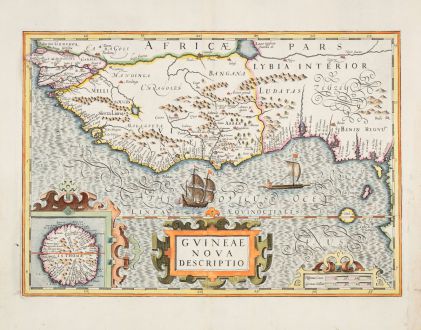
Guineae Nova Descriptio
Jodocus Hondius (*1563 - †1612)Reference 12873
Description
Highly decorative antique map by Jodocus Hondius, showing the West African Coast from Rio Senego (Senegal) to Cape Lopez, just below the equator. The map extends its coverage to include Guinea, parts of Benin, and Lybia, with a detailed inset of St. Thomas. From the French edition of the Mercator-Hondius Atlas printed in 1633.
This map is part of Hondius' first edition of Mercator's Atlas, offering a valuable record of the western coast of Africa. Focused on the region from the Senegal River to the islands of Fernando Po and São Principe, it reflects the Portuguese exploration and mapping of the area.
Portuguese explorers, starting with Nuno Tristão in the early 1440s, reached significant milestones like the Senegal River, establishing trade posts along the coast, including Cacheu in modern-day Guinea-Bissau. The trade in this region encompassed commodities such as gold, ivory, spices, and sadly, the slave trade. The islands of São Tomé and Principe played crucial roles as transshipment points for the latter.
In the early 17th century, when Hondius created Guineae Nova Descriptio, Portugal still held dominance in this region, although competition from Dutch and English powers was on the rise. The map provides a retrospective look at Portuguese influence, capturing key ports, river systems, and geographical features before the Dutch maritime influence began to challenge Portuguese control.
Details
| Cartographer | Jodocus Hondius |
| Title | Guineae Nova Descriptio |
| Publisher, Year | H. Hondius, Amsterdam, 1633 |
| Plate Size | 34.5 x 49.0 cm (13.6 x 19.3 inches) |
| Sheet Size | 48.9 x 56.4 cm (19.3 x 22.2 inches) |
| Reference | Van der Krogt, P.: Koeman's Atlantes Neerlandici, 8700:1A. |
Condition
Cartographer
Images to Download
If you like to download the image of this map with a resolution of 1200 pixels, please follow the link below.
You can use this image for publication on your personal or commercial websites for free if you set a link to this website. If you need photographs with a higher resolution, please contact us.

![[Manuscript Chart of the South Atlantic Ocean] Tweede stuck wassende Graedkaert van de Kaap Verdische Eilanden tot de Kaap [Manuscript Chart of the South Atlantic Ocean] Tweede stuck wassende Graedkaert van de Kaap Verdische Eilanden tot de Kaap](https://www.vintage-maps.com/3745-home_default/blaeu-manuscript-1690.jpg)
![[Tab. Mo. Primae Partis Aphricae et Tabula Secunde partis Aphricae.] [Tab. Mo. Primae Partis Aphricae et Tabula Secunde partis Aphricae.]](https://www.vintage-maps.com/3651-home_default/fries-north-africa-1525.jpg)
