Product successfully added to your shopping cart
There are 0 items in your cart. There is 1 item in your cart.
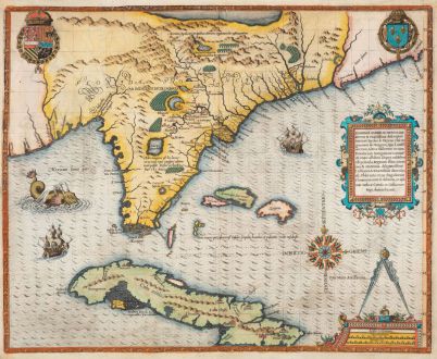
Floridae Americae Provinciae Recens & exactissima descriptio Auctore Iacobo le Moyne...
Theodor de Bry (*1528 - †1598)Reference 12743
Description
One of the Most Important 16th Century Maps of Florida and the Southeastern United States.
A very fine example of De Bry's cornerstone map of Florida. Based on the map Jacques le Moyne prepared after he accompanied the French Huguenot explorer Laudonniere to Florida in 1564. Le Moyne's map shows the peninsula of Florida with the surrounding regions and the northern part of Cuba. From Theodor de Bry's Grand Voyages printed 1591 in Frankfurt.
Philip D. Burden in The Mapping of North America about this map (#79):
Le Moyne reached England where he must have proceeded to draw from his memory. He spent the rest of his life in London. De Bry travelled there about 1587 and tried to purchase these drawings, to no avail. The following year, however, le Moyne died and he bought them from his widow. The manuscript map (if there was one) has not survived and only one watercolour exists, that being in the New York Public Library.
Despite the fact that this map was not very accurate its influence was considerable. This is mainly because Hondius used it for his map of the area in 1606, the atlas in which it occurred was Mercator's and his fame was enough to prolong its authority until the Blaeu Virginiae partis australis, c. 1638. Latitudinally it was fairly accurate but as always it was the longitude that was incorrect. This led to a vastly extended eastward slant of the coastline. Most of the information on the map is derived from Indian sources and not French ones. Much of the nomenclature did not survive the arrival of the English, with the obvious exceptions of Port Royal and Prom. Canaueral. The later colonies of Carolina were named after King Charles II of England, its presence here was purely coincidental. Several lakes are shown including what is thought to be a representation of the sea of Verrazzano, an apocryphal route through to Asia. However, with the nearby presence of a large waterfall, many believing it to represent Indian tales of Niagara Falls, it could in fact be the Great Lakes.
W.P. Cumming in The Southeast in Early Maps (#14):
The map contains many striking details, frequently erroneous, which were incorporated in other maps for over 150 years. It was Le Moyne's misfortune to have many of his errors incorporated and even exaggerated in Mercator's map of 1606, upon which for half a century much of the subsequent cartography of the region was based.... Along the coast are Latin names for rivers and bays, such as Gironda, Garumna, and Charenta, together with a few of the earlier Spanish names. The identification of the rivers has been attempted several times but it is doubtful whether Le Moyne had definite knowledge of the number of rivers along the coast himself. The names were given on the first voyage under Ribaut, who in his account makes some reference to their latitude and appearance.
This map comes from the second part of De Bry's Grand Voyages, titled Der ander Theyl, der Newlich erfundenen Landtschafft Americae. The first Latin and German editions were printed 1591 in Frankfurt. A second German edition was published in 1603. The Latin edition was titled Brevis narratio eorum quae in Florida Americae provincia Gallis acciderunt.
Details
| Cartographer | Theodor de Bry |
| Title | Floridae Americae Provinciae Recens & exactissima descriptio Auctore Iacobo le Moyne... |
| Publisher, Year | Theodor de Bry, Frankfurt, 1591 |
| Plate Size | 36.7 x 45.4 cm (14.4 x 17.9 inches) |
| Sheet Size | 38.5 x 46.5 cm (15.2 x 18.3 inches) |
| Reference | Burden, P.D.: The Mapping of North America No. 79; Cumming, W.P.: The Southeast in Early Maps, No. 14. |
Condition
Cartographer
Theodor de Bry was a Flemish engraver and publisher, born in 1528 in Liege. 1578 he moved with his family to Frankfurt am Main, where he founded an engraving and publishing company.
In the years 1586 and 1588 he lived in London, where he worked with the geographer Richard Hakluyt. He collected travel reports and illustrations of European research expeditions. After his return in 1589, T. de Bry and his sons Johann Theodor and Johann Israel began to publish the two most important collections of Renaissance travelogue. Between 1590 and 1634, they published under the title America and the New World and India orientalis a comprehensive work out of 27 volumes, which are the most important travel books of the 16th Century. Equipped with large copper plate illustrations and explanatory text, a work arose that documents until today, how the countries of the Americas, Africa and Asia and its inhabitants looked like at the time of discovery and how the Europeans saw them.
Theodor de Bry was able to publish only six parts of his complete work. After his death in 1598, the work was continued by his sons and later by Johann Theodor's son-in-law Matthew Merian until 1634.
Images to Download
If you like to download the image of this map with a resolution of 1200 pixels, please follow the link below.
You can use this image for publication on your personal or commercial websites for free if you set a link to this website. If you need photographs with a higher resolution, please contact us.
North America - Bry, Theodor de - Floridae Americae Provinciae Recens &...

