Product successfully added to your shopping cart
There are 0 items in your cart. There is 1 item in your cart.
Total products
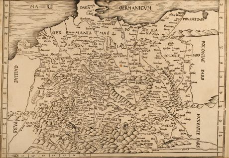
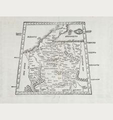
Tabula Moderna Germanie
Martin Waldseemüller (*1473 - †1520)Antique woodcut map of Germany. Printed in Strasbourg by Schott in 1513 or 1520.
Reference 10157
Description
This very detailed early woodcut map showing central Europe from Denmark to the Alps and from France to Poland. This Ptolemaic map comes from the first so called Modern Atlas by Martin Waldseemuller since it is the first Ptolemy edition with twenty new regional maps beside the traditional twenty-seven Ptolemaic maps derived from the 1482 Ulm edition. The Atlas is titled GEOGRAPHIE OPUS NOVISSIMA TRADUCTIONE E GRECORUM ARCHETYPIS published by Johann Schott in Strassburg 1513 and is one of the most important edition of Ptolemy Atlases. In 1520 a second edition of the atlas was printed by Schott from the same woodcut blocks. It was reissued 1522 and 1525 by Laurent Fries and Johannes Gruninger with size reduced maps.
Details
| Cartographer | Martin Waldseemüller |
| Title | Tabula Moderna Germanie |
| Publisher, Year | Schott, Strasbourg, 1513 or 1520 |
| Plate Size | 38.5 x 54.0 cm (15.2 x 21.3 inches) |
Condition
The title Tabvla Moderna Germanie on top has been cut off, also only small margin on bottom left. Some overall browning, small tear in the top left margin that crosses into the image area, some foxing. Overall fine condition.
Cartographer
Martin Waldseemuller was born 1473 in Wolfenweiler close to Freiburg. He has a unique part in the history of cartography, since he is responsible for the naming of AMERICA, the new discovered continent. The most famous maps of Waldseemuller have been discovered as late as 1901 in the family castle of Prince Johannes Waldburg-Wolfegg in southern Germany. One map is the 12 sheet woodcut map from 1507 also called America's birth certificate the first known document showing the name America and reflects the discoveries of Christopher Columbus and Amerigo Vespucci. The second map is a rare sea chart from 1516 - knows as Carta Marina. He died in 1520.
Images to Download
If you like to download the image of this map with a resolution of 1200 pixels, please follow the link below.
You can use this image for publication on your personal or commercial websites for free if you set a link to this website. If you need photographs with a higher resolution, please contact us.
Martin Waldseemüller: Tabula Moderna Germanie.
Antique woodcut map of Germany. Printed in Strasbourg by Schott in 1513 or 1520.

![[Donau Strom von Sigmaringen bis Donauwörth] [Donau Strom von Sigmaringen bis Donauwörth]](https://www.vintage-maps.com/2606-home_default/anonymous-germany-baden-wuerttemberg-danube-1702.jpg)



![[De Boemia. / Tabula quarta & quinta Europae de nonnullis / Germaniae ...] [De Boemia. / Tabula quarta & quinta Europae de nonnullis / Germaniae ...]](https://www.vintage-maps.com/2304-home_default/fries-germany-1541.jpg)
