Product successfully added to your shopping cart
There are 0 items in your cart. There is 1 item in your cart.
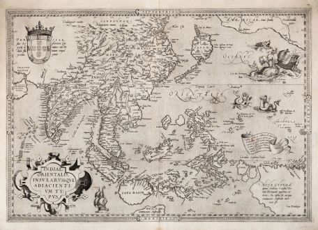
Indiae Orientalis Insularumque Adiacientium Typus
Abraham Ortelius (*1527 - †1598)Reference 11762
Description
Rare first edition, first state of Ortelius' striking map of Southeast Asia.
Rare and important first edition of the beautiful Southeast Asia map of Abraham Ortelius. From the first 'modern' atlas Theatrum Orbis Terrarum of 1570, published by Gielis Coppens van Diest in Antwerp. According to Marcel van den Broecken, only 225 copies of this first edition were printed. It remains as one of Abraham Ortelius' best-known maps.
The mapping of Southeast Asia has been difficult for centuries. Thus, Sumatra and Java are heavily oversized, the Philippines are incomplete and still without the Island of Luzon. The cartographic information is largely based on Mercator's world map of 1569, but it contains many improvements over previous maps. Ortelius identified the Pearl River correctly in southern China, while Mercator believed Sumatra is Ptolemy's Taprobana, and concluded the Pearl River was the Ganges River. The important spice islands (Moluccas) are more accurately positioned against the former Italian maps of Gastaldi, Forlani and Ramusio. The shape of Halmahera (formerly Gilolo) was also corrected by Ortelius. For the first time several islands called Cainam appeared west of New Guinea, which is an early rendering of Irian Jaya. Ortelius questions in the text within New Guinea, whether it is a part of the southern continent or an island.
Thomas Suarez about this map:
The Asiae Nova Descriptio and Indiae Orientalis are the first published works to definitely map Formosa, and to identify it by that name (Fermosa). For the Ryukyu chain itself, Ortelius uses the terms Lequiho and Lequio, forms of Liu-ch'iu....
The Indiae Orientalis' depiction of two mermaids with mirrors may hark back to the old lore regarding an 'island of women' who conceived by beholding their own image- one missionary report actually located an amazonian island to the south of the Marianas, near Ortelius' two figures...
Ortelius accepted Mercator's belief in an imposing southern continent and in the theory that Marco Polo reached its shores. The Indiae Orientalis extends far enough south to depict the northernmost promontory of Terra Australis protruding below Java, with the Polian kingdom of Beach (a corruption of Lucach occupying its shores...
The map is decorated with a large title cartouche, the Portuguese coat of arms and two sailing ships, of which one is attacked by two whales. The two mermaids with mirrors are taken from the splendid map of America of Diego Gutiérrez from 1562.
A very good, early and strong impression. Especially because the map is uncoloured, the beauty of the engraving is clearly visible.
Details
| Cartographer | Abraham Ortelius |
| Title | Indiae Orientalis Insularumque Adiacientium Typus |
| Publisher, Year | Gielis van Diest, Antwerp, 1570 |
| Plate Size | 34.7 x 49.6 cm (13.7 x 19.5 inches) |
| Sheet Size | 38.4 x 52.4 cm (15.1 x 20.6 inches) |
| Reference | Van den Broecke, M.: Ortelius Atlas Maps, No. 166.1; Van der Krogt, P.: Koeman's Atlantes Neerlandici, 8400:31:001; Suarez, T.: Early Mapping of Southeast Asia, pp. 164-69, fig. 86. |
Condition
Cartographer
Images to Download
If you like to download the image of this map with a resolution of 1200 pixels, please follow the link below.
You can use this image for publication on your personal or commercial websites for free if you set a link to this website. If you need photographs with a higher resolution, please contact us.
Southeast Asia - Ortelius, Abraham - Indiae Orientalis Insularumque...

![[Maidegascar, Zanzibar, Scorsia, Inebila, Imangla, Scilam, Dondina] [Maidegascar, Zanzibar, Scorsia, Inebila, Imangla, Scilam, Dondina]](https://www.vintage-maps.com/2957-home_default/bordone-east-africa-madagascar-sri-lanka-1528-1565.jpg)
![[Java Minore] [Java Minore]](https://www.vintage-maps.com/2959-home_default/bordone-southeast-asia-indonesia-sumatra-thailand-borneo.jpg)
