Product successfully added to your shopping cart
There are 0 items in your cart. There is 1 item in your cart.

Abrahami Patriarchae Peregrinatio, et Vita
Abraham Ortelius (*1527 - †1598)Reference 11744
Description
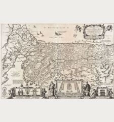
Rare edition of Ortelius' striking map of the Wanderings of Abraham.
A rare edition of the historical map of the Holy Land by Abraham Ortelius, unusual without text on verso. Shows the land of Canaan with an inset map depicting the wanderings of Abraham, the first patriarch of Judaism. Surrounded by 22 medallions showing scenes of Abraham's life. The map itself is drawn as a Flemish wall tapestry and decorated with two cartouches.
Kenneth Nebenzahl about this map:
The Wanderings of Abraham is among the most elaborate of Ortelius's compositions. It demonstrates his combined skills as a cartographer and an artist, and his accomplishment as an historian.
This copy of the important map does not come from the Atlas Theatrum Orbis Terrarum or Parergon as usual, but was printed separately as a single sheet, at the request of a customer. The used plate is the first of two almost identical plates (v. d. Broecke Ort 182), since the hatching in the background of the medallions is running from lower left to upper right. The medallions already have the known changes, makes it the second state of the plate. Since no map without text on verso from this state of the first plate was bound into an atlas, our copy is a rare, separately sold print. It was most likely bound into a composite atlas as the map has a guard on verso.
A very good and strong impression. Especially because the map is uncoloured, the beauty of the engraving is clearly visible.
Details
| Cartographer | Abraham Ortelius |
| Title | Abrahami Patriarchae Peregrinatio, et Vita |
| Publisher, Year | Antwerp, circa 1595 |
| Plate Size | 35.6 x 45.5 cm (14.0 x 17.9 inches) |
| Sheet Size | 41.7 x 54.4 cm (16.4 x 21.4 inches) |
| Reference | Van den Broecke, M.: Ortelius Atlas Maps, No. 182; Laor, E.: Maps of the Holy Land: Cartobibliography of Printed Maps, 1475-1900, No. 547.; Nebenzahl, K.: Maps of the Holy Lands: Images of Terra Sancta Through Two Milleni, No. 34 |
Condition
Cartographer
Images to Download
If you like to download the image of this map with a resolution of 1200 pixels, please follow the link below.
You can use this image for publication on your personal or commercial websites for free if you set a link to this website. If you need photographs with a higher resolution, please contact us.
Holy Land - Ortelius, Abraham - Abrahami Patriarchae Peregrinatio, et Vita

![[Die Tafel gibt ein klein anzeigung...] [Die Tafel gibt ein klein anzeigung...]](https://www.vintage-maps.com/1544-home_default/muenster-holy-land-israel-cyprus-1574.jpg)

![[Nile River delta] [Nile River delta]](https://www.vintage-maps.com/2049-home_default/muenster-egypt-nile-river-1574.jpg)
