Product successfully added to your shopping cart
There are 0 items in your cart. There is 1 item in your cart.
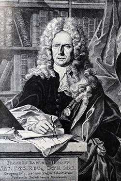
Antique Maps by Johann Baptist Homann (*1664 - †1724)

Tabula Geographica qua pars Russiae Magnae Pontus Euxinus seu Mare Nigrum et Tartaria Minor ...
J. B. Homann, Nuremberg, circa 1720
Unusual map of South Russia with the Black Sea region and the Ukraine. Extends from Moscow to Constantinople. The waters of the Dnieper and Danube are shown as currents in the Black Sea converging...
Tabula Geographica qua pars Russiae Magnae Pontus Euxinus seu Mare...
1720 - Johann Baptist Homann
10934Coloured map of the Black Sea. Printed in Nuremberg by J. B. Homann circa 1720.
Sold
Ukrania quae et Terra Cosaccorum cum vicinis Walachiae, Moldaviae, Minorisq., Tartariae...
J. B. Homann, Nuremberg, circa 1720
Beautiful map of the Ukraine with the Black Sea and Crimea. Extends from Moscow to Constantinople. With a marvellous figural cartouche composed of native figures. Published 1720 by J.B. Homann in...
Ukrania quae et Terra Cosaccorum cum vicinis Walachiae, Moldaviae,...
1720 - Johann Baptist Homann
10936Antique map of the Black Sea. Printed in Nuremberg by J. B. Homann circa 1720.
Sold
Tabula Geographica qua pars Russiae Magnae Pontus Euxinus seu Mare Nigrum et Tartaria Minor ...
J. B. Homann, Nuremberg, circa 1720
Original old coloured map of the Black Sea region with southern part of Russia and the Ukraine. Extends from Moscow to Constantinople. The waters of the Dnieper and Danube are shown as currents in...
Tabula Geographica qua pars Russiae Magnae Pontus Euxinus seu Mare...
1720 - Johann Baptist Homann
11482Old coloured map of the Black Sea. Printed in Nuremberg by J. B. Homann circa 1720.
Sold
Generalis totius Imperii Moscovitici Novissima Tabula. Magnam Orbis Terrarum Partem a Polo...
J. B. Homann, Nuremberg, circa 1720
Decorative map of the Russian Empire with original publishers colour. Showing the Northeast Passage. With beautiful cartouche, ships and sea monsters around Spitsbergen.
Generalis totius Imperii Moscovitici Novissima Tabula. Magnam Orbis...
1720 - Johann Baptist Homann
11484Old coloured map of Russia. Printed in Nuremberg by J. B. Homann circa 1720.
Sold
Plan der Belagerung von Friedrichshall, angefangen von Carl dem XII der Schweden Goth und Wenden...
Nuremberg, circa 1720
Rare and very decorative plan of the siege of Fredrikshald (Halden) and its fortress Fredriksten in 1718. The engraved plan by Johann Baptist Homann shows the military intervention of King Charles...
Plan der Belagerung von Friedrichshall, angefangen von Carl dem XII der...
1720 - Johann Baptist Homann
11495Old coloured map of the Fortress Fredriksten, Fredrikshald, Halden. Printed in Nuremberg circa 1720.
Sold
Tabula Ducatus Carnioliae Vindorum Marchiae et Histriae
J. B. Homann, Nuremberg, circa 1720
Old coloured engraved map of the former Duchy of Carniola (Kranjska) by J.B. Homann. Shows today's Slovenia and Croatia. With an inset map of the Lake Cerknica (Cerkniško jezero) and a great view...
Tabula Ducatus Carnioliae Vindorum Marchiae et Histriae
1720 - Johann Baptist Homann
11501Old coloured map of Laibach, Ljubljana, Slovenia, Croatia. Printed in Nuremberg by J. B. Homann circa 1720.
Sold
Imperium Turcicum in Europa, Asia et Africa Regiones Proprias, Tributarias, Clientelares ...
J. B. Homann, Nuremberg, circa 1720
Beautiful old coloured map of the Turkish Empire by Johann Baptist Homann. Very decorative map of the Ottoman Empire issued during the first half of the 18th Century. Shows the eastern...
Imperium Turcicum in Europa, Asia et Africa Regiones Proprias,...
1720 - Johann Baptist Homann
11708Old coloured map of the Ottoman Empire. Printed in Nuremberg by J. B. Homann circa 1720.
Sold
Imperii Persici in Omnes suas Provincias
J. B. Homann, Nuremberg, circa 1720
Beautiful old coloured map of the Persian Empire by Johann Baptist Homann. Shows Iran, Iraq, Syria, the Persian Gulf, the Caspian Sea as well as parts of the eastern Mediterranean with Cyprus and...
Imperii Persici in Omnes suas Provincias
1720 - Johann Baptist Homann
11709Old coloured map of Persia / Iran / Iraq / Syria / Persian Gulf. Printed in Nuremberg by J. B. Homann circa 1720.
Sold
Peloponesus hodie Moreae Regnum in Omnes suas Provincias Veteres et Hodiernas Accurate Divisum
J. B. Homann, Nuremberg, circa 1720
Old coloured engraved map of the Peloponnese (Morea, Pelopónnisos), a large peninsula in southern Greece by Johann Baptist Homann. The skillful title cartouche shows the Lion of Saint Mark with...
Peloponesus hodie Moreae Regnum in Omnes suas Provincias Veteres et...
1720 - Johann Baptist Homann
11711Old coloured map of the Peloponnese. Printed in Nuremberg by J. B. Homann circa 1720.
Sold
Insula Creta hodie Candia in sua IV Territoria Divisa ...
J. B. Homann, Nuremberg, circa 1720
Old coloured engraved map of Crete (Κρήτη) with the Cyclades (Κυκλάδες) in the Aegean Sea by Johann Baptist Homann. The skillful title cartouche shows Poseidon surrounded by grape vines.
Insula Creta hodie Candia in sua IV Territoria Divisa ...
1720 - Johann Baptist Homann
11712Old coloured map of Crete, Cyclades, Aegean Sea. Printed in Nuremberg by J. B. Homann circa 1720.
Sold
Fluviorum in Europa Principis Danubii cum Adiacentibus Regnis, nec non Totius Graeciae et...
J. B. Homann, Nuremberg, circa 1720
Old coloured engraved map of the course of the river Danube by Johann Baptist Homann. Shows the Danube river from Donaueschingen to the Black Sea. Left a small inset map from the mouth up to...
Fluviorum in Europa Principis Danubii cum Adiacentibus Regnis, nec non...
1720 - Johann Baptist Homann
11715Old coloured map of the Danube. Printed in Nuremberg by J. B. Homann circa 1720.
Sold
Danubii Fluminis ... Pars Media in qua Hungaria, Sclavonia, Bosnia, Dalmatia et Servia ...
J. B. Homann, Nuremberg, circa 1720
Old coloured engraved map of the course of the river Danube by Johann Baptist Homann. Shows the Danube river from Linz in Austria, via Vienna, Belgrade, up to Vidin in Bulgaria. Bottom left the...
Danubii Fluminis ... Pars Media in qua Hungaria, Sclavonia, Bosnia,...
1720 - Johann Baptist Homann
11717Old coloured map of the Danube. Printed in Nuremberg by J. B. Homann circa 1720.
Sold
Ducatuum Livoniae et Curlandiae cum Vicinis Insulis
Johann Baptist Homann, Nuremberg, circa 1720
Beautiful, old coloured map of the Baltic region by Johann Baptist Homann. With Estonia, Latvia and Lithuania, the east coast of the Baltic Sea and the Gulf of Finland in the north. Very detailed...
Ducatuum Livoniae et Curlandiae cum Vicinis Insulis
1720 - Johann Baptist Homann
11718Old coloured map of Estonia, Lithuania and Latvia. Printed in Nuremberg by Johann Baptist Homann circa 1720.
Sold
Totius Regni Galliae sive Franciae Tabula ...
J. B. Homann, Nuremberg, circa 1720
Beautiful, old coloured map of France by Johann Baptist Homann. With a beautiful, skillful finished title cartouche and coat of arms of the individual regions.
Totius Regni Galliae sive Franciae Tabula ...
1720 - Johann Baptist Homann
11719Old coloured map of France. Printed in Nuremberg by J. B. Homann circa 1720.
Sold![Homann, Spain - Portugal, Brazil, 1720: Portugalliae et Algarbiae ... [inset Brazil] Regnum Brasiliae in America Australi]( "Johann Baptist Homann: Portugalliae et Algarbiae ... [inset Brazil] Regnum Brasiliae in America Australi")
Portugalliae et Algarbiae ... [inset Brazil] Regnum Brasiliae in America Australi
J. B. Homann, Nuremberg, circa 1720
Beautiful, old coloured map of Portugal by Johann Baptist Homann. With a large inset (20x20 cm) of the Portuguese colonies in Brazil. On the Atlantic Ocean the English and Portuguese fleets under...
Portugalliae et Algarbiae ... [inset Brazil] Regnum Brasiliae in America...
1720 - Johann Baptist Homann
11720Old coloured map of Brazil. Printed in Nuremberg by J. B. Homann circa 1720.
Sold
Germania Austriaca Complectens S.R.I. Circulum Austriacum ut et Reliquas in Germania ...
Johann Baptist Homann, Nuremberg, circa 1720
Old coloured map of Austria by Johann Baptist Homann. Shows the area between the Upper Rhine and Heidelberg in the northwest, large parts of Switzerland down to Milan in the southwest, Croatia in...
Germania Austriaca Complectens S.R.I. Circulum Austriacum ut et Reliquas...
1720 - Johann Baptist Homann
11721Old coloured map of Austria - Hungary. Printed in Nuremberg by Johann Baptist Homann circa 1720.
Sold
Archiducatus Austriae Inferioris
Johann Baptist Homann, Nuremberg, circa 1720
Old coloured map of Lower Austria by Johann Baptist Homann. Shows the area along the Danube from Steyr and Enns, over Vienna to Hainburg and Bratislava (Pressburg). The following major cities are...
Archiducatus Austriae Inferioris
1720 - Johann Baptist Homann
11722Old coloured map of Austria - Hungary. Printed in Nuremberg by Johann Baptist Homann circa 1720.
Sold
Tabula Ducatus Carnioliae Vindorum Marchiae et Histriae
Johann Baptist Homann, Nuremberg, circa 1720
Old coloured map of the former Duchy of Carniola (Kranjska) by Johann Baptist Homann. Shows today's Slovenia and Croatia. From Villach and Klagenfurt in the northwest and from Palmanovo over...
Tabula Ducatus Carnioliae Vindorum Marchiae et Histriae
1720 - Johann Baptist Homann
11723Old coloured map of Laibach, Ljubljana, Slovenia, Croatia. Printed in Nuremberg by Johann Baptist Homann circa 1720.
Sold
Ducatus Stiriae Novissima Tabula ...
Johann Baptist Homann, Nuremberg, circa 1720
Old coloured map of Styria by Johann Baptist Homann. Shows the area around the Drau and Mur river from the Wolfgangsee and Hallstätter See in the northwest, Klagenfurt with the Wörthersee in the...
Ducatus Stiriae Novissima Tabula ...
1720 - Johann Baptist Homann
11724Old coloured map of Carinthia, Styria, Graz. Printed in Nuremberg by Johann Baptist Homann circa 1720.
Sold
Nova et Accurata Carinthiae Ducatus ...
Johann Baptist Homann, Nuremberg, circa 1720
Old coloured map of Carinthia by Johann Baptist Homann. Shows the area between the Königssee with the Obersee and Zeller See in the northwest over Villach and Klagenfurt to Windischgrätz (Slovenj...
Nova et Accurata Carinthiae Ducatus ...
1720 - Johann Baptist Homann
11725Old coloured map of Carinthia, Klagenfurt. Printed in Nuremberg by Johann Baptist Homann circa 1720.
Sold
Tabula Generalis Marchionatus Moraviae in Sex Circulos Divisae ...
Johann Baptist Homann, Nuremberg, circa 1720
Old coloured map of Moravia (Morava) by Johann Baptist Homann. Shows the southeastern part of the Czech Republic between Pelhřimov (Pilgrams) in the northwest, Racibórz (Ratibor) in the northeast...
Tabula Generalis Marchionatus Moraviae in Sex Circulos Divisae ...
1720 - Johann Baptist Homann
11726Old coloured map of Moravia. Printed in Nuremberg by Johann Baptist Homann circa 1720.
Sold
Totius Marchionatus Lusatiae tam superioris quam inferioris tabula specialis in suos Comitatus et...
Johann Baptist Homann, Nuremberg, circa 1720
Old coloured map of Lower and Upper Lusatia by Johann Baptist Homann. Shows the area between Baruth/Mark and Teupitz in the northwest, from Torgau along the Elbe river over Riesa, Meißen, Dresden...
Totius Marchionatus Lusatiae tam superioris quam inferioris tabula...
1720 - Johann Baptist Homann
11727Old coloured map of Saxony, Brandenburg, Lusatia (Lausitz). Printed in Nuremberg by Johann Baptist Homann circa 1720.
Sold
Superioris et Inferioris Ducatus Silesiae in suos XVII Minores Principatus et Dominia Divisi Nova...
Johann Baptist Homann, Nuremberg, circa 1720
Old coloured map of Silesia by Johann Baptist Homann. Shows the southwestern part of Poland between Frankfurt Oder in the northwest, over Krosno Odrzańskie, Głogów, Freiberg, Brzeg, Racibórz and...
Superioris et Inferioris Ducatus Silesiae in suos XVII Minores...
1720 - Johann Baptist Homann
11728Old coloured map of Wroclaw, Breslau, Silesia. Printed in Nuremberg by Johann Baptist Homann circa 1720.
Sold
Regni Bohemiae, Ducatus Silesiae, Marchionatus Moraviae et Lusatiae. Tabula Generalis
Johann Baptist Homann, Nuremberg, circa 1720
Old coloured map of the Czech Republic with parts of Poland by Johann Baptist Homann. Shows the area between Frankfurt Oder in the north, along the Oder river to Krosno Odrzańskie, Głogów, Wrocław,...
Regni Bohemiae, Ducatus Silesiae, Marchionatus Moraviae et Lusatiae....
1720 - Johann Baptist Homann
11730Old coloured map of Wroclaw, Breslau, Silesia. Printed in Nuremberg by Johann Baptist Homann circa 1720.
Sold


![Homann, Spain - Portugal, Brazil, 1720: Portugalliae et Algarbiae ... [inset Brazil] Regnum Brasiliae in America Australi](https://www.vintage-maps.com/2157-home_default/homann-spain-portugal-brazil-1720.jpg "Johann Baptist Homann: Portugalliae et Algarbiae ... [inset Brazil] Regnum Brasiliae in America Australi")


