Product successfully added to your shopping cart
There are 0 items in your cart. There is 1 item in your cart.
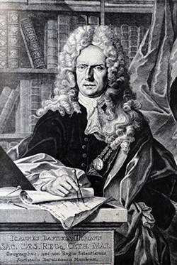
Antique Maps by Johann Baptist Homann (*1664 - †1724)

Novissima & Exactissima Totius Regni Neapolis Tabula ...
Johann Baptist Homann, Nuremberg, circa 1720
Old coloured map of Southern Italy (Italia meridionale) by Johann Baptist Homann. Shows the southern regions of Italy between L'Aquila and Gaeta in the northwest, Naples (Napoli) and the southern...
Novissima & Exactissima Totius Regni Neapolis Tabula ...
1720 - Johann Baptist Homann
11736Old coloured map of Molise, Campania, Basilicata, Puglia, Calabria. Printed in Nuremberg by Johann Baptist Homann circa 1720.
Sold
Circuli Westphaliae in Omnes suos Status et Provincias
Johann Baptist Homann, Nuremberg, circa 1720
Old coloured map of Lower Saxony and North Rhine-Westphalia by by Johann Baptist Homann. Shows the area between Hamburg, Cologne, Oldenburg and Hanover. Centred around Münster and Osnabrück....
Circuli Westphaliae in Omnes suos Status et Provincias
1720 - Johann Baptist Homann
11751Old coloured map of North Rhine-Westphalia, Lower Saxony. Printed in Nuremberg by Johann Baptist Homann circa 1720.
Sold
Circulus Saxoniae Inferioris in omnes suos Status et Principatus
Johann Baptist Homann, Nuremberg, circa 1720
Old coloured map of the northern part of Germany by Johann Baptist Homann. Shows the area between Kiel, Rügen, Berlin, Halle and Oldenburg in the west. To the lower left a city view of Hamburg....
Circulus Saxoniae Inferioris in omnes suos Status et Principatus
1720 - Johann Baptist Homann
11752Old coloured map of North Germany, Lower Saxony, Hamburg. Printed in Nuremberg by Johann Baptist Homann circa 1720.
Sold
Potentissimae Helvetiorum Reipublicae Cantones Tredecim cum Foederatis et Subjectis Provinciis
Homann, Nuremberg, circa 1720
Old coloured map of Switzerland by Johann Baptist Homann. The large title cartouche shows 13 coat of arms of the cantons and 20 coat of arms of large cities. Bottom left a scene of a local cheese...
Potentissimae Helvetiorum Reipublicae Cantones Tredecim cum Foederatis...
1720 - Johann Baptist Homann
11753Old coloured map of Switzerland. Printed in Nuremberg by Homann circa 1720.
Sold
Tabula generalis totius Belgii qua Provinciae XVII Infer. Germania olim sub S.R.I. Circula...
Johann Baptist Homann, Nuremberg, circa 1720
Old coloured map of the Benelux countries by Johann Baptist Homann. Shows the area between the Seine estuary and the Ems. Among the provinces Flanders, Brabant, Luxembourg, Geldern and Limburg. In...
Tabula generalis totius Belgii qua Provinciae XVII Infer. Germania olim...
1720 - Johann Baptist Homann
11755Old coloured map of the Low Countries. Printed in Nuremberg by Johann Baptist Homann circa 1720.
Sold
Belgii Pars Septentrionalis Communi Nomine vulgo Hollandia ... / Batavorum Coloniae Occidential...
J. B. Homann, Nuremberg, circa 1720
Original old coloured map of the Low Countries by J. B. Homann. With large inset maps of the Northeastern US from the Chesapeake to Massachusetts and Southeast Asia and additional vignette views of...
Belgii Pars Septentrionalis Communi Nomine vulgo Hollandia ... /...
1720 - Johann Baptist Homann
11756Old coloured map of Jakarta, New York. Printed in Nuremberg by J. B. Homann circa 1720.
Sold
Comitatus Flandriae in omnes ejusdem subjacentes Ditioes cum adjacentibus accuratissime divisus...
J. B. Homann, Nuremberg, circa 1720
Old coloured engraved map of Flanders (Vlaanderen) by Johann Baptist Homann. Shows the coastline of the North Sea between Gravelines and the Scheldt estuary, with Antwerp and Brussels to the east....
Comitatus Flandriae in omnes ejusdem subjacentes Ditioes cum...
1720 - Johann Baptist Homann
11758Old coloured map of Flanders (Vlaanderen). Printed in Nuremberg by J. B. Homann circa 1720.
Sold
Hiberniae Regnum tam in Praecipuas Ultoniae, Connaciae, Laceniae et Momoniae quam in Minores...
J. B. Homann, Nuremberg, circa 1720
Old coloured engraved map of Ireland by Johann Baptist Homann. The beautiful title cartouche shows the Irish coat of arms with the Celtic harp, below a decorative mileage scale with the coat of...
Hiberniae Regnum tam in Praecipuas Ultoniae, Connaciae, Laceniae et...
1720 - Johann Baptist Homann
11759Old coloured map of Ireland. Printed in Nuremberg by J. B. Homann circa 1720.
Sold
Magnae Britanniae Pars Septentrionalis qua Regnum Scotiae ...
J. B. Homann, Nuremberg, circa 1720
Old coloured engraved map of Scotland by Johann Baptist Homann. The beautiful title cartouche shows the coat of arms of the United Kingdom, on the upper right a decorative mileage scale with the...
Magnae Britanniae Pars Septentrionalis qua Regnum Scotiae ...
1720 - Johann Baptist Homann
11760Old coloured map of Scotland. Printed in Nuremberg by J. B. Homann circa 1720.
Sold
Magnae Britanniae Pars Meridionalis in qua Regnum Angliae tam in Septem Antiqua Anglo-Saxonum...
J. B. Homann, Nuremberg, circa 1720
Old coloured engraved map of England by Johann Baptist Homann. The beautiful title cartouche shows the coat of arms of the United Kingdom, in the lower left the coat of arms of England surrounded...
Magnae Britanniae Pars Meridionalis in qua Regnum Angliae tam in Septem...
1720 - Johann Baptist Homann
11761Old coloured map of England. Printed in Nuremberg by J. B. Homann circa 1720.
Sold
Archiducatus Austriae Superioris...
Johann Baptist Homann, Nuremberg, circa 1720
Old coloured antique map of Upper Austria by Johann Baptist Homann. Shows the area along the Danube from Braunau and Passau, via Linz, Enns, Grein to Ypps on the Danube. Bottom left the Königsee,...
Archiducatus Austriae Superioris...
1720 - Johann Baptist Homann
11790Old coloured map of Upper Austria. Printed in Nuremberg by Johann Baptist Homann circa 1720.
Sold
S.R.I. Circulus Rhenanus sive Electorum Rheni
J. B. Homann, Nuremberg, circa 1720
Very detailed, old-coloured engraved map of central Germany with Rhineland-Palatinate, North Rhine-Westphalia, Hesse and parts of Baden-Württemberg. Shows the area between the Rhineland in the...
S.R.I. Circulus Rhenanus sive Electorum Rheni
1720 - Johann Baptist Homann
11791Old coloured map of North Rhine-Westphalia, Rhineland. Printed in Nuremberg by J. B. Homann circa 1720.
Sold
Tabula Marchionatus Brandenburgici et Ducatus Pomeraniae
J. B. Homann, Nuremberg, circa 1720
Old colored engraved antique map of Mecklenburg-Vorpommern by J. B. Homann. Shows the coast of the Baltic Sea from Holstein with Oldenburg to Rügen and Usedom and Gdansk. With a nice title...
Tabula Marchionatus Brandenburgici et Ducatus Pomeraniae
1720 - Johann Baptist Homann
11793Old coloured map of Mecklenburg-Vorpommern. Printed in Nuremberg by J. B. Homann circa 1720.
Sold
S.R.I. Circulus Rhenanus Superior
J. B. Homann, Nuremberg, circa 1720
Very detailed, old-coloured engraved map of Hesse. Shows the area between the Rhine with Mainz to the lower left up to Mühlhausen in the northeast. With a beautiful title cartouche at the top left...
S.R.I. Circulus Rhenanus Superior
1720 - Johann Baptist Homann
11794Old coloured map of Hesse. Printed in Nuremberg by J. B. Homann circa 1720.
Sold
Ducatus Bremae et Ferdae Nova Tabula
J. B. Homann, Nuremberg, circa 1720
Old coloured antique map of the northwestern part of Lower Saxony by J. B. Homann. Shows the North Sea coast with Helgoland Bay, Weser and Elbe with Bremen, Hamburg and Oldenburg. With a beautiful...
Ducatus Bremae et Ferdae Nova Tabula
1720 - Johann Baptist Homann
11799Old coloured map of Hamburg, Bremen, Lower Saxony. Printed in Nuremberg by J. B. Homann circa 1720.
Sold
Ducatus Meklenburgici Tabula Generalis Continens Duc. Vandaliae et Meklenburg Comitatum et...
J. B. Homann, Nuremberg, circa 1720
Old colored antique map of Mecklenburg-Vorpommern by J. B. Homann. Shows the Baltic Sea coastline from Holstein with Fehmarn, Travemünde and Lübeck via Wismar and Rostock to Rügen. In the south,...
Ducatus Meklenburgici Tabula Generalis Continens Duc. Vandaliae et...
1720 - Johann Baptist Homann
11800Old coloured map of Mecklenburg-Vorpommern. Printed in Nuremberg by J. B. Homann circa 1720.
Sold
Tabula Generalis Holsatiae Complectens Holsatiae, Dithmarsiae, Stormariae, et Vagriae Ducatus
J. B. Homann, Nuremberg, circa 1720
Very detailed, old coloured antique map of Holstein by J. B. Homann. Below the Elbe river with Hamburg to Lauenburg and Boizenburg. Highlighted by different colours, the historic landscapes:...
Tabula Generalis Holsatiae Complectens Holsatiae, Dithmarsiae,...
1720 - Johann Baptist Homann
11801Old coloured map of Lübeck, Kiel, Hamburg, Schleswig-Holstein. Printed in Nuremberg by J. B. Homann circa 1720.
Sold
Circuli Franconiae Pars Orientalis et Potior ...
J. B. Homann, Nuremberg, circa 1720
Old coloured, very detailed map of Franconia, Bavaria by J. B. Homann. With Würzburg, Regensburg, Bamberg, Coburg, Ingolstadt, Bayreuth and Nuremberg in the center. With a beautiful title cartouche...
Circuli Franconiae Pars Orientalis et Potior ...
1720 - Johann Baptist Homann
11802Old coloured map of Franconia, Bavaria. Printed in Nuremberg by J. B. Homann circa 1720.
Sold
Regnorum Siciliae et Sardiniae nec non Melitae seu Maltae Insula cum Adjectis Italiae et Africae...
J. B. Homann, Nuremberg, circa 1720
Old coloured antique map of Sicily, Sardinia and Malta located in the Mediterranean Sea. To the lower left a map of Catania with Etna in the background. To the right a small map of Valletta, Malta....
Regnorum Siciliae et Sardiniae nec non Melitae seu Maltae Insula cum...
1720 - Johann Baptist Homann
11804Old coloured map of Malta, Sardinia, Sicily. Printed in Nuremberg by J. B. Homann circa 1720.
Sold
Regni Daniae in quo sunt Ducatus Holsatia et Slesvicum Insulae Danicae Provinciae Iutia Scania...
J. B. Homann, Nuremberg, circa 1720
Old coloured engraved map of Denmark by Johann Baptist Homann. With the southern part of Sweden, the Mecklenburg Baltic Sea coast with Rügen and Schleswig-Holstein. The beautiful title cartouche...
Regni Daniae in quo sunt Ducatus Holsatia et Slesvicum Insulae Danicae...
1720 - Johann Baptist Homann
11805Old coloured map of Denmark. Printed in Nuremberg by J. B. Homann circa 1720.
Sold
Scandinavia Complectens Sueciae, Daniae & Norvegiae Regna ex Tabulis Ioh. Baptistae Homanni
J. B. Homann, Nuremberg, circa 1720
Old coloured antique map of Scandinavia by Johann Baptist Homann. With Norway, Sweden, Finland and Denmark. Top left a magnificent title cartouche.
Scandinavia Complectens Sueciae, Daniae & Norvegiae Regna ex Tabulis...
1720 - Johann Baptist Homann
11806Old coloured map of Scandinavia. Printed in Nuremberg by J. B. Homann circa 1720.
Sold
Regni Norvegiae Accurata Tabula in qua Praefecturae Quinque Generales Aggerhusiensis, Bergensis...
J. B. Homann, Nuremberg, circa 1720
Old coloured engraved map of Norway by Johann Baptist Homann. Top left an inset with the Lofoten to the North Cape. The beautiful title cartouche shows the Norwegian coat of arms.
Regni Norvegiae Accurata Tabula in qua Praefecturae Quinque Generales...
1720 - Johann Baptist Homann
11807Old coloured map of Norway. Printed in Nuremberg by J. B. Homann circa 1720.
Sold
Neue Tafel vor alle Liebhabers und See-fahrende Personen Stellet vor ein Orlog oder Kriegs-Schiff...
J. B. Homann, Nuremberg, circa 1720
Large, old coloured engraving of a warship by Johann Baptist Homann. Published around 1720 in Nuremberg. Shows a three-master battleship with dinghies in the centre, below the cross section of the...
Neue Tafel vor alle Liebhabers und See-fahrende Personen Stellet vor ein...
1720 - Johann Baptist Homann
11809Copper engraving of a maritim scenery. Warship. Printed in Nuremberg by J. B. Homann circa 1720.
Sold
Tafel in welcher alle gehörige Werck-zeuge zur Kriegs-Kunst, Vestungs-bau und Artillerie, zu...
J. B. Homann, Nuremberg, circa 1720
Large, old coloured engraving with numerous illustrations of siege and war technology by Johann Baptist Homann. Including different military equipment such as cannons, mortars, battle axes, various...
Tafel in welcher alle gehörige Werck-zeuge zur Kriegs-Kunst,...
1720 - Johann Baptist Homann
11810Copper engraving of a military scene. Printed in Nuremberg by J. B. Homann circa 1720.
Sold


