Product successfully added to your shopping cart
There are 0 items in your cart. There is 1 item in your cart.
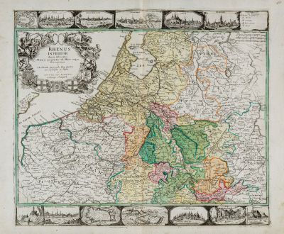
Rhenus Inferior denuo delineatus Moeno coniunctus ad Mare usque Germanicum a I. B....
Gottfried Jacob Haupt (*1715 - †1766)Reference 11795
Description
A very rare engraved map of the Lower Rhine and the Netherlands. One of the few maps of the engraver Gottfried Jacob Haupt from Augsburg. Only very few copies of this map are known.
Depicted is the area between Frankfurt and Hanau in the southeast, Friesland in the north and the English Channel with Dover and Calais in the east. Surrounded by 10 city views and 3 city maps, with Schenkenschanz, Neuss, Jülich, Dusseldorf, Kleve, Nijmegen, Katzenelnbogen, Mainz, Bonn, Koblenz, Cologne and St. Goar with Rheinfels Castle. Top left a title cartouche with 7 coats of arms.
We are aware of two states of the copper plate which was used to print this map. In addition to the first state shown here, there is at least a second state, which has a revised title cartouche. The name of the author G. J. Haupt(io) was replaced by J. B. Probst and a legend was drawn instead of the empty shield. The plan of Schenkenschanz was changed and numerous places and descriptions of the seas were added.
According to our research, only the following copies of this map are available in public collections and libraries:
- Bayerische Staatbibliothek, Munich: Nolin/Haupt: 1st state
- Yale University Library, USA: Nolin/Probst, 2nd state, strong defects
- British Library, London: Nolin/Probst, 2nd state
- Kremsmünster Abbey, Benedictine Monastery, Austria: Nolin/Probst, 2nd state
Thus, we only could find another example with Gottfried Jacob Haupt in the title cartouche, from the later state at least three more exists.
Details
| Cartographer | Gottfried Jacob Haupt |
| Title | Rhenus Inferior denuo delineatus Moeno coniunctus ad Mare usque Germanicum a I. B. Nolin Geographo Reg. Gallico aeri insculptus et editus a Gottofr. Iac. Hauptio Calcogr. August. |
| Publisher, Year | Gottfried Jacob Haupt, Augsburg, circa 1740 |
| Plate Size | 47.5 x 56.1 cm (18.7 x 22.1 inches) |
| Sheet Size | 52.7 x 63.6 cm (20.7 x 25.0 inches) |
Condition
Cartographer
Images to Download
If you like to download the image of this map with a resolution of 1200 pixels, please follow the link below.
You can use this image for publication on your personal or commercial websites for free if you set a link to this website. If you need photographs with a higher resolution, please contact us.
Germany - Haupt, Gottfried Jacob - Rhenus Inferior denuo delineatus Moeno...

![[Donau Strom von Sigmaringen bis Donauwörth] [Donau Strom von Sigmaringen bis Donauwörth]](https://www.vintage-maps.com/2606-home_default/anonymous-germany-baden-wuerttemberg-danube-1702.jpg)



![[De Boemia. / Tabula quarta & quinta Europae de nonnullis / Germaniae ...] [De Boemia. / Tabula quarta & quinta Europae de nonnullis / Germaniae ...]](https://www.vintage-maps.com/2304-home_default/fries-germany-1541.jpg)
