Product successfully added to your shopping cart
There are 0 items in your cart. There is 1 item in your cart.
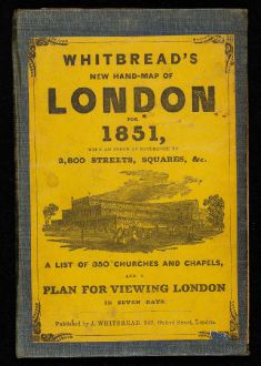
Whitbread's New Hand-Map of London for 1851 - Whitbread's New Plan of London drawn from...
Josiah WhitbreadReference 12356
Description
First edition of Whitbread's iconic pocket map of London. The folded map shows Victorian London shortly before the Great Exhibition of the Works of Industry of All Nations which took place in London's Hyde Park from 1st May to 15th October 1851. The plan was published two months earlier and is dated to February 26, 1851. On the cover the Crystal Palace is shown.
In the original cardboard linen binder with the original and complete 30-page booklet titled Index to New Plan of London; containing references to 2,800 streets, squares,, &c. A list of 350 churches and chapels... and a plan for viewing London in seven days. At the end of the booklet the entrance fees to the The Great Industrial Exhibition of 1851. Remarkable the difference in entrance fees for ladies and gentlemen.
.Details
| Cartographer | Josiah Whitbread |
| Title | Whitbread's New Hand-Map of London for 1851 - Whitbread's New Plan of London drawn from authentic surveys |
| Publisher, Year | J. Whitbread, London, 1851 |
| Plate Size | 44.0 x 65.0 cm (17.3 x 25.6 inches) |
| Sheet Size | 44.0 x 65.0 cm (17.3 x 25.6 inches) |
| Reference | Hyde, R.: Printed Maps of Victorian London, 1851-1900, No. 24 |
Condition
Cartographer
Images to Download
If you like to download the image of this map with a resolution of 1200 pixels, please follow the link below.
You can use this image for publication on your personal or commercial websites for free if you set a link to this website. If you need photographs with a higher resolution, please contact us.
British Isles - Whitbread, Josiah - Whitbread's New Hand-Map of London for...


![[British Isles and England & Wales] [British Isles and England & Wales]](https://www.vintage-maps.com/2941-home_default/bordone-british-isles-england-and-wales-1528-1565.jpg)

![[The Firth of Murry] - To the Rt Hon.ble, my Lord Viscount Torbat, Lord Register of the Kingdom of Scotland [The Firth of Murry] - To the Rt Hon.ble, my Lord Viscount Torbat, Lord Register of the Kingdom of Scotland](https://www.vintage-maps.com/2244-home_default/collins-scotland-north-sea-moray-firth-inverness.jpg)

![[Von den Britannischen Inseln...] [Von den Britannischen Inseln...]](https://www.vintage-maps.com/1653-home_default/muenster-british-isles-england-scotland-ireland-1574.jpg)