Product successfully added to your shopping cart
There are 0 items in your cart. There is 1 item in your cart.
Total products
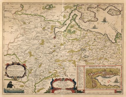
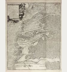
Landtcarte Vonn dem Ambte Flensborg, ohne Nordgoeßherde. Anno 1648.
Johannes Mejer (*1606 - †1674)Old coloured map of Flensburg. Printed in Husum by Petersen in 1652.
Reference 10468
Description
Beautiful old coloured map of Flensburg from Matthias and Claus Petersen after Johannes Mejer. With detailed plan of Flensburg, two coloured cartouches and sailing ships. From Caspar Danckwerth's Atlas "Newe Landesbeschreibung Der Zwey Hertzogthümer Schleswich und Holstein". Plate later acquired by Blaeu and used in his "Atlas Major".
Details
| Cartographer | Johannes Mejer |
| Title | Landtcarte Vonn dem Ambte Flensborg, ohne Nordgoeßherde. Anno 1648. |
| Publisher, Year | Petersen, Husum, 1652 |
| Plate Size | 42.6 x 56.5 cm (16.8 x 22.2 inches) |
| Sheet Size | 46.0 x 59.5 cm (18.1 x 23.4 inches) |
Condition
Overall browning, magins backed.
Cartographer
Johannes Mejer, a geographer and mathematician, was born 1606 in Husum. He has mapped Schleswig and Holstein in the years 1638 to 1648. The resulting maps have been published in Danckwerth's Atlas Newe Landesbeschreibung der zwey Hertzogthümer Schleswich und Holstein in 1652. The copper plates were sold to J. Blaeu and re-published in his Atlas Major. Mejer died in 1674.
Images to Download
If you like to download the image of this map with a resolution of 1200 pixels, please follow the link below.
You can use this image for publication on your personal or commercial websites for free if you set a link to this website. If you need photographs with a higher resolution, please contact us.
Johannes Mejer: Landtcarte Vonn dem Ambte Flensborg, ohne Nordgoeßherde. Anno 1648..
Old coloured map of Flensburg. Printed in Husum by Petersen in 1652.
Germany - Mejer, Johannes - Landtcarte Vonn dem Ambte Flensborg, ohne...

![[Donau Strom von Sigmaringen bis Donauwörth] [Donau Strom von Sigmaringen bis Donauwörth]](https://www.vintage-maps.com/2606-home_default/anonymous-germany-baden-wuerttemberg-danube-1702.jpg)



![[De Boemia. / Tabula quarta & quinta Europae de nonnullis / Germaniae ...] [De Boemia. / Tabula quarta & quinta Europae de nonnullis / Germaniae ...]](https://www.vintage-maps.com/2304-home_default/fries-germany-1541.jpg)
