Product successfully added to your shopping cart
There are 0 items in your cart. There is 1 item in your cart.
Total products
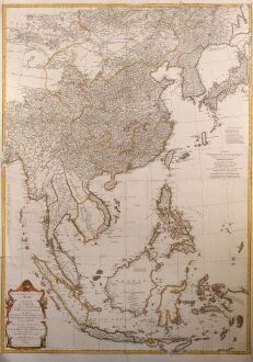
Seconde partie de la carte d'Asie contenant la Chine et partie de la Tratarie, l'Inde...
Jean Baptiste d'Anville (*1697 - †1782)Coloured map of Southeast Asia. Printed in the year 1752.
Reference 10080
Description
Attractive large map of Asia from G. de la Haye by J.B.B. d'Anville. Showing south east Asia with Japan and Korea. Printed on two plates, joined.
Details
| Cartographer | Jean Baptiste d'Anville |
| Title | Seconde partie de la carte d'Asie contenant la Chine et partie de la Tratarie, l'Inde ... Sumatra, Java, Borneo, Moluques, Philippines et du Japon |
| Publisher, Year | 1752 |
| Plate Size | 97.8 x 69.5 cm (38.5 x 27.4 inches) |
| Reference | Walter S. 46/47 |
Condition
Mounted in margin, some tears in margin, fine conditions.
Cartographer
Jean Baptiste Bourguignon d'Anville, born 1697 in Paris, was recongnized as one of the finest cartographers of his time. From 1740 onwards, he published a map collection titled Atlas Générale which was published in many editions within the next century. (Antique Maps, Moreland & Bannister). He died 1782 in Paris.
Images to Download
If you like to download the image of this map with a resolution of 1200 pixels, please follow the link below.
You can use this image for publication on your personal or commercial websites for free if you set a link to this website. If you need photographs with a higher resolution, please contact us.
Jean Baptiste d'Anville: Seconde partie de la carte d'Asie contenant la Chine et partie de la Tratarie, l'Inde ... Sumatra, Java, Borneo, Moluques,....
Coloured map of Southeast Asia. Printed in the year 1752.
Southeast Asia - d'Anville, Jean Baptiste - Seconde partie de la carte d'Asie...


![[Maidegascar, Zanzibar, Scorsia, Inebila, Imangla, Scilam, Dondina] [Maidegascar, Zanzibar, Scorsia, Inebila, Imangla, Scilam, Dondina]](https://www.vintage-maps.com/2957-home_default/bordone-east-africa-madagascar-sri-lanka-1528-1565.jpg)
![[Java Minore] [Java Minore]](https://www.vintage-maps.com/2959-home_default/bordone-southeast-asia-indonesia-sumatra-thailand-borneo.jpg)
