Product successfully added to your shopping cart
There are 0 items in your cart. There is 1 item in your cart.
Total products
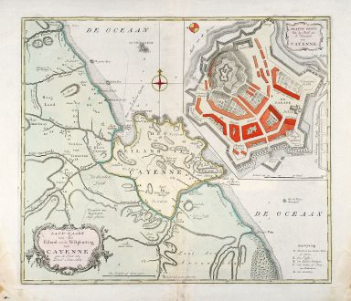
Land-Kaart van het Eiland en de Volkplanting van Cayenne aan de Kust van Zuid-Amerika
Isaak Tirion (*1705 - †1765)Coloured map of Cayenne, French Guyana. Printed in Amsterdam circa 1765.
Reference 10407
Description
Attractive engraved map of French Guyana by I. Tirion. Showing the coast of French Guyana with a plan of Cayenne and the fortifications. With two cartouches and a compass rose.
Details
| Cartographer | Isaak Tirion |
| Title | Land-Kaart van het Eiland en de Volkplanting van Cayenne aan de Kust van Zuid-Amerika |
| Publisher, Year | Amsterdam, circa 1765 |
| Plate Size | 35.6 x 41.5 cm (14.0 x 16.3 inches) |
| Sheet Size | 41.5 x 48.0 cm (16.3 x 18.9 inches) |
Condition
Minor waterstained in lower corners not affecting the image.
Cartographer
Isaak Tirion, a Dutch publisher in Amsterdam, was born 1705. He produced serveral Atlases and Dutch town plans. The maps mainly based on those of Guillaume de l'Isle. He died in 1765.
Images to Download
If you like to download the image of this map with a resolution of 1200 pixels, please follow the link below.
You can use this image for publication on your personal or commercial websites for free if you set a link to this website. If you need photographs with a higher resolution, please contact us.
Isaak Tirion: Land-Kaart van het Eiland en de Volkplanting van Cayenne aan de Kust van Zuid-Amerika.
Coloured map of Cayenne, French Guyana. Printed in Amsterdam circa 1765.
South America - Tirion, Isaak - Land-Kaart van het Eiland en de...

![[West Indies, Jamaica, Hispaniola and South America] [West Indies, Jamaica, Hispaniola and South America]](https://www.vintage-maps.com/3035-home_default/bordone-central-america-caribbean-jamaica-hispaniola.jpg)
