Product successfully added to your shopping cart
There are 0 items in your cart. There is 1 item in your cart.
Total products
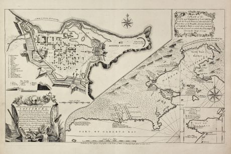
A Plan of the City, and Fortifications, of Louisburg, from a Survey made by Richard...
Thomas Jefferys (*1695 - †1771)Antique map of Louisbourg, Nova Scotia, Canada. Printed in London by le Rouge in 1757.
Reference 10973
Description
Important and very rare map describing the first siege of Louisbourg in 1745
The copper engraved map published by Thomas Jefferys in 1757 showing the Siege of Louisbourg, which took place in 1745 when a New England Colonial force aided by a British fleet captured Louisbourg on the island of Île-Royale (now called Cape Breton Island) from its French defenders during the War of the Austrian Succession, known as King George's War in the British colonies. The map has a large inset at left: "A Plan of the City and Fortifications of Louisburg ..." and a smaller inset of Gabarus Bay.
We only could locate one copy of this 1757 first state of the map world wide. It can be found in the British Library. There is a second state of the map depicting the siege of 1758, which appears more frequently.
Details
| Cartographer | Thomas Jefferys |
| Title | A Plan of the City, and Fortifications, of Louisburg, from a Survey made by Richard Gridley / A Plan of the City and Harbour of Louisburg. |
| Publisher, Year | le Rouge, London, 1757 |
| Plate Size | 38.7 x 62.3 cm (15.2 x 24.5 inches) |
| Sheet Size | 51.5 x 66.4 cm (20.3 x 26.1 inches) |
Condition
Dark and clear impression on strong paper. Perfect condition. It is quite unusual to find a separate published map in such preservation.
Cartographer
Thomas Jefferys was an english cartographer and publisher. He produced one of the finest maps of the time of the West Indies and North America. Jefferys also published english country maps.
Images to Download
If you like to download the image of this map with a resolution of 1200 pixels, please follow the link below.
You can use this image for publication on your personal or commercial websites for free if you set a link to this website. If you need photographs with a higher resolution, please contact us.
Thomas Jefferys: A Plan of the City, and Fortifications, of Louisburg, from a Survey made by Richard Gridley / A Plan of the City and Harbour....
Antique map of Louisbourg, Nova Scotia, Canada. Printed in London by le Rouge in 1757.
North America - Jefferys, Thomas - A Plan of the City, and Fortifications, of...

