Produkt wurde in den Korb gelegt
Sie haben 0 Artikel in Ihrem Warenkorb. Es gibt 1 Artikel in Ihrem Warenkorb.
Gesamt Artikel
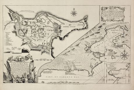
A Plan of the City, and Fortifications, of Louisburg, from a Survey made by Richard...
Thomas Jefferys (*1695 - †1771)Antike Landkarte von Louisbourg, Neuschottland, Kanada. Gedruckt bei le Rouge im Jahre 1757 in London.
Artikel-Nr. 10973
Beschreibung
Wichtige und äußerst seltene Karte der Belagerung von Louisbourg 1745
The copper engraved map published by Thomas Jefferys in 1757 showing the Siege of Louisbourg, which took place in 1745 when a New England Colonial force aided by a British fleet captured Louisbourg on the island of Île-Royale (now called Cape Breton Island) from its French defenders during the War of the Austrian Succession, known as King George's War in the British colonies. The map has a large inset at left: "A Plan of the City and Fortifications of Louisburg ..." and a smaller inset of Gabarus Bay.
We only could locate one copy of this 1757 first state of the map world wide. It can be found in the British Library. There is a second state of the map depicting the siege of 1758, which appears more frequently.
Details
| Kartograph | Thomas Jefferys |
| Titel | A Plan of the City, and Fortifications, of Louisburg, from a Survey made by Richard Gridley / A Plan of the City and Harbour of Louisburg. |
| Verlag, Jahr | le Rouge, London, 1757 |
| Bildgröße | 38.7 x 62.3 cm |
| Blattgröße | 51.5 x 66.4 cm |
Erhaltung
Kräftiger und klarer Abdruck auf festem Papier. Perfekter Zustand.
Kartograph
Thomas Jefferys war englischer Kartograph und Verleger. Er publizierte die besten Nordamerika- und Karibikkarten seiner Zeit. Jefferys verlegte auch englische Regionalkarten.
Bilder zum Herunterladen
Falls Sie die Bilder dieser Karte in einer Auflösung von 1200 Pixeln herunterladen möchten, folgen Sie bitte unten stehendem Verweis.
Sie können die Bilder auf Ihrer privaten oder kommerziellen Internetseite frei veröffentlichen, sofern Sie einen Verweis (Link) auf diese Webseite setzen. Falls Sie Fotos in höherer Auflösung benötigen, kontaktieren Sie uns bitte.
Thomas Jefferys: A Plan of the City, and Fortifications, of Louisburg, from a Survey made by Richard Gridley / A Plan of the City and Harbour....
Antike Landkarte von Louisbourg, Neuschottland, Kanada. Gedruckt bei le Rouge im Jahre 1757 in London.
Nordamerika - Jefferys, Thomas - A Plan of the City, and Fortifications, of...

