Product successfully added to your shopping cart
There are 0 items in your cart. There is 1 item in your cart.
Amerique Septentrionale Divisee en Ses Principales Parties [and] L'Amerique Meridionale...
Alexis Hubert Jaillot (*1632 - †1712)Reference 11770
Description
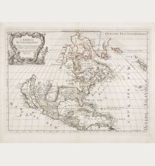
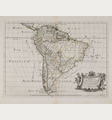
A matching set of two old colored maps of North and South America by Alexis Hubert Jaillot. California is still shown as an island and the Great Lakes are shown with open ends in the West. Separate running Latin titles appears above the neat line: America Septentrionalis in suas Praecipuas Partes Divisa, ad usum Serenissimi Burgundiae Ducis and America Meridionalis in suas Praecipuas Partes Accurate Divisa, ad usum Serenissimi Burgundiae Ducis.
The map is based on the larger map of Jaillot of 1674 and was first published in his Atlas Royal in 1694. The copper plates passed to P. Mortier, but were never used by him. Around the year 1726 a second state appeared, after Ottens bought the Jaillot plates. This example corresponds to the third state with Chez R. & J. Ottens in the lower cartouche and appeared around the year 1729. In later states the copper plates were updated and California is correctly represented as a peninsula, not as shown here as an island.
Details
| Cartographer | Alexis Hubert Jaillot |
| Title | Amerique Septentrionale Divisee en Ses Principales Parties [and] L'Amerique Meridionale Divisee en Ses Principales Parties. |
| Publisher, Year | R. & J. Ottens, Amsterdam, 1694 (1729) |
| Plate Size | 48.1 x 58.1 cm (18.9 x 22.9 inches) |
| Sheet Size | 52.7 x 62.5 cm (20.7 x 24.6 inches) |
| Reference | Burden, P.D.: The Mapping of North America No. 700, state 3; McLaughlin, G.; Mayo, N.H.: The Mapping of California as an Island: An Illustrated Checklist, No. 113 |
Condition
Cartographer
Images to Download
If you like to download the image of this map with a resolution of 1200 pixels, please follow the link below.
You can use this image for publication on your personal or commercial websites for free if you set a link to this website. If you need photographs with a higher resolution, please contact us.
America Continent - Jaillot, Alexis Hubert - Amerique Septentrionale Divisee en Ses...

![Alexis Hubert Jaillot: Amerique Septentrionale Divisee en Ses Principales Parties [and] L'Amerique Meridionale Divisee en Ses Principales Parties. Antique Maps, Jaillot, America Continent, 1694 (1729): Amerique Septentrionale Divisee en Ses Principales Parties [and] L'Amerique Meridionale Divisee en Ses Principales Parties.](https://www.vintage-maps.com/3645-large_default/jaillot-america-continent-1694-1729.jpg)
