Product successfully added to your shopping cart
There are 0 items in your cart. There is 1 item in your cart.
Total products
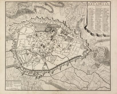
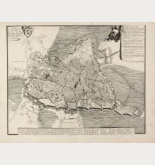
Plan de la ville de Brusselle, Ville Noble au Duche de Brabant, et les delices des Pays...
Covens and MortierAntique map of Brussels. Printed in Amsterdam by Covens & Mortier circa 1740.
Reference 11049
Description
Impressive and very rare plan of Brussels by Covens & Mortier. This city plan is engraved by F. De Bakker and published in Amsterdam after 1712. The plan is a copy of the Herrewyn plan, issued by Fricx in 1711. The main buildings have been represented individually and streetnames are in Flemish. The crooked street near the rue de Terre-Neuve, the Beguinage and the alleys all correspond with the Herrewyn paln, the newly built charitable institution is not mentioned yet and the fire-stuck gate is still standing. The French legend with its 112 entries has been changed slightly and a scale has been added. We only could locate three copies of this plan in international libraries.
Details
| Cartographer | Covens and Mortier |
| Title | Plan de la ville de Brusselle, Ville Noble au Duche de Brabant, et les delices des Pays Bas. |
| Publisher, Year | Covens & Mortier, Amsterdam, circa 1740 |
| Plate Size | 49.3 x 57.9 cm (19.4 x 22.8 inches) |
| Sheet Size | 53.0 x 67.8 cm (20.9 x 26.7 inches) |
| Reference | Danckaert, L.: Bruxelles: cinq siècles de cartographie #41 |
Condition
On heavy paper, strong and clear impression. Minor staining in margin. Excellent conditions.
Cartographer
Pieter und David Mortier were booksellers in Paris and have published a wide range of geographical works. After Pieter's death, his widow continued the business until their son Cornelius took over. Cornelius started a partnership with his brother-in-law Johannes Covens and established the famous publishing house Covens and Mortier in Amsterdam. They have re-issued Atlases of Sanson, de l'Isle, Visscher and de Wit.
Images to Download
If you like to download the image of this map with a resolution of 1200 pixels, please follow the link below.
You can use this image for publication on your personal or commercial websites for free if you set a link to this website. If you need photographs with a higher resolution, please contact us.
Covens and Mortier: Plan de la ville de Brusselle, Ville Noble au Duche de Brabant, et les delices des Pays Bas..
Antique map of Brussels. Printed in Amsterdam by Covens & Mortier circa 1740.
Belgium - Covens and Mortier - Plan de la ville de Brusselle, Ville Noble...

