Product successfully added to your shopping cart
There are 0 items in your cart. There is 1 item in your cart.
Total products

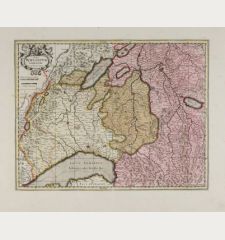
Novissima et Accuratissima Helvetiae, Rhaetiae, Valesiae et Partis Sabaudiae Tabula
Justus Danckerts (*1635 - †1701)Old coloured map of Switzerland. Printed circa 1680.
Reference 10059
Description
Detailed map of Switzerland including South Germany with the Lake of Constance and Liechtenstein. Map from Jeremias Wolff by J. Danckerts.
Details
| Cartographer | Justus Danckerts |
| Title | Novissima et Accuratissima Helvetiae, Rhaetiae, Valesiae et Partis Sabaudiae Tabula |
| Publisher, Year | circa 1680 |
| Plate Size | 48.4 x 56.4 cm (19.1 x 22.2 inches) |
Condition
Centerfold professionally repaired, small margin. Good conditions.
Cartographer
The Danckerts family sold and published maps during the 17th Century in Amsterdam. Justus Danckerts, the son of the business founder Cornelius Danckerts, was born 1635. He has published several Atlases together with his son Theodorus between 1680 and 1700. The plates finally have been sold to R. & J. Ottens how published them on their own name. He died in 1701.
Images to Download
If you like to download the image of this map with a resolution of 1200 pixels, please follow the link below.
You can use this image for publication on your personal or commercial websites for free if you set a link to this website. If you need photographs with a higher resolution, please contact us.
Justus Danckerts: Novissima et Accuratissima Helvetiae, Rhaetiae, Valesiae et Partis Sabaudiae Tabula.
Old coloured map of Switzerland. Printed circa 1680.
Switzerland - Danckerts, Justus - Novissima et Accuratissima Helvetiae,...


![[Nova Helvetiae tabula geographica] [Nova Helvetiae tabula geographica]](https://www.vintage-maps.com/3425-home_default/scheuchzer-switzerland-lake-geneva-1720.jpg)

![[ohne Titel] [ohne Titel]](https://www.vintage-maps.com/1915-home_default/muenster-switzerland-fribourg-freiburg-im-ueechtland-1574.jpg)
