Product successfully added to your shopping cart
There are 0 items in your cart. There is 1 item in your cart.
Total products
![Johann Jakob Scheuchzer: [Nova Helvetiae tabula geographica] Antique Maps, Scheuchzer, Switzerland, Lake Geneva, 1720: [Nova Helvetiae tabula geographica]](https://www.vintage-maps.com/3425-large_default/scheuchzer-switzerland-lake-geneva-1720.jpg)
[Nova Helvetiae tabula geographica]
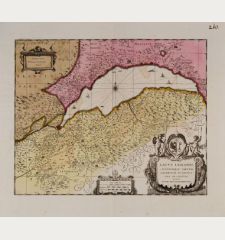
Johann Jakob Scheuchzer (*1672 - †1733)Old coloured map of the Lake Geneva and the Swiss Alps. Printed in Amsterdam by P. Schenk circa 1720.
Reference 12473
Description
Old coloured map of Lake Geneva by J. J. Scheuchzer. The lower left sheet of Scheuchzer's 1713 map of Switzerland in 4 sheets. This is the edition by Pieter Schenk printed in Amsterdam. Shows Lake Geneva, Lake Brienz, Lake Thun, the Valais Alps and the Bernese Alps. With rich marginal illustrations of natural wonders of Switzerland. Including the Drachenstein of Lucerne and the Gemmi Pass.
Details
| Cartographer | Johann Jakob Scheuchzer |
| Title | [Nova Helvetiae tabula geographica] |
| Publisher, Year | P. Schenk, Amsterdam, circa 1720 |
| Plate Size | 47.0 x 56.5 cm (18.5 x 22.2 inches) |
| Sheet Size | 52.0 x 59.3 cm (20.5 x 23.3 inches) |
Condition
Very good condition.
Cartographer
Johann Jakob Scheuchzer was a Swiss physician, naturalist, geographer and is considered one of Switzerland's most important polymaths. He became best known for his interpretation of fossils as remnants of the Great Flood. During his studies of the Alps, Scheuchzer produced a map of Switzerland in 4 sheets in 1713, which is considered the best map of Switzerland of its time.
Images to Download
If you like to download the image of this map with a resolution of 1200 pixels, please follow the link below.
You can use this image for publication on your personal or commercial websites for free if you set a link to this website. If you need photographs with a higher resolution, please contact us.
Johann Jakob Scheuchzer: [Nova Helvetiae tabula geographica].
Old coloured map of the Lake Geneva and the Swiss Alps. Printed in Amsterdam by P. Schenk circa 1720.
Switzerland - Scheuchzer, Johann Jakob - [Nova Helvetiae tabula geographica]



![[ohne Titel] [ohne Titel]](https://www.vintage-maps.com/1915-home_default/muenster-switzerland-fribourg-freiburg-im-ueechtland-1574.jpg)
![[Neuwnburger See] [Neuwnburger See]](https://www.vintage-maps.com/1642-home_default/muenster-switzerland-lake-neuchatel-lac-de-neuchatel-1574.jpg)
