Product successfully added to your shopping cart
There are 0 items in your cart. There is 1 item in your cart.
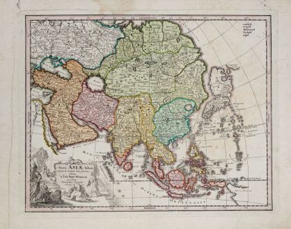
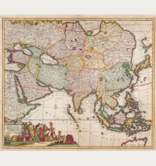
Nova Asiae tabula majori in minorem hanc formani reducta a Joh. Bapt. Homann
Christoph Weigel (*1654 - †1725)Reference 11955
Description
Scarce map of Asia by Christoph Weigel after J. B. Homann. Still without Kamchatka, but with the big island of Terra Yedso above Japan. Compagnie Land to the upper right could be an early representation of Alaska or a misrepresentation of Hokkaido. With an outline of Nova Hollandia and Carpentaria, both parts of Australia. Also mentioned the Dampier Strait, named Dampieri, separates New Guinea and New Britain. Decorated with a beautiful title cartouche. From Bequemer Schul- und Reisen-Atlas also titled Atlas scholasticus et itinerarius by Christoph Weigel. Weigel's well-known travel atlas, which he published in collaboration with Professor Johann David Köhler.
Details
| Cartographer | Christoph Weigel |
| Title | Nova Asiae tabula majori in minorem hanc formani reducta a Joh. Bapt. Homann |
| Publisher, Year | Johann Ernst Adelbulner, Nuremberg, 1718 |
| Plate Size | 27.6 x 34.4 cm (10.9 x 13.5 inches) |
| Sheet Size | 34.0 x 42.0 cm (13.4 x 16.5 inches) |
Condition
Cartographer
Images to Download
If you like to download the image of this map with a resolution of 1200 pixels, please follow the link below.
You can use this image for publication on your personal or commercial websites for free if you set a link to this website. If you need photographs with a higher resolution, please contact us.
Asian Continent - Weigel, Christoph - Nova Asiae tabula majori in minorem hanc...

