Product successfully added to your shopping cart
There are 0 items in your cart. There is 1 item in your cart.
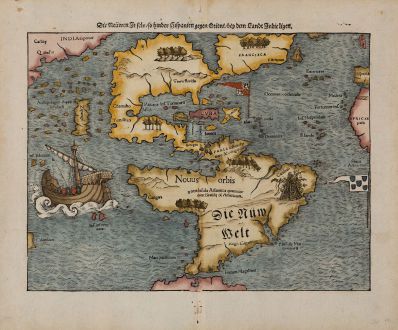
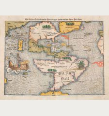
Die Neuwen Inseln / so hinder Hispanien gegen Orient / bey dem Landt Indie ligen
Sebastian Münster (*1489 - †1552)Reference 11326
Description
Earliest appearance of Japan on a map, predating European contact.
First appearance of Mare Pacificum on a map.
Sebastian Munster's woodcut map of the New World is one of the most important maps in American cartography.
Burden notes to this map:
The map inclusion in Münster's Cosmography, first published in 1544, sealed the fate of 'America' as the name for the New World...
The Portuguese flag is shown flying over the South Atlantic and the Spanish one over her possessions in the Caribbean. The Strait of Magellan are named again, and Mare pacificum appears for the first time on a printed map. Magellan's ship Victoria, the only survivor of five vessels, appears in the middle of this ocean. Marco Polo's influence can be seen with Zipangri (Japan) appearing three years before the earliest known contact with Europeans, and also his Archipelagus 7448 insularu. The Yucatan is still shown as an island and the lake at Temistitan is depicted emptying into the Gulf of Mexico.
The title on verso is surrounded by a beautiful woodcut border. The woodblock of this map was first used in Seb. Munster's Geographia Universalis in 1540. Munster was one of the first to create space in the woodblocks for the insertion of place-names in metal type. In the follow the text was changed frequently and the identification of the different states of the map is possible. This copy comes from the German edition of Sebastian Munster's Cosmography, titled Cosmographey oder beschreibung aller Länder, published 1574 by Heinrich Petri in Basel.
Details
| Cartographer | Sebastian Münster |
| Title | Die Neuwen Inseln / so hinder Hispanien gegen Orient / bey dem Landt Indie ligen |
| Publisher, Year | Heinrich Petri, Basle, 1540 (1574) |
| Plate Size | 25.7 x 34.3 cm (10.1 x 13.5 inches) |
| Sheet Size | 33.5 x 40.4 cm (13.2 x 15.9 inches) |
| Reference | Burden, P.D.: The Mapping of North America No. 12. |
Condition
Cartographer
Images to Download
If you like to download the image of this map with a resolution of 1200 pixels, please follow the link below.
You can use this image for publication on your personal or commercial websites for free if you set a link to this website. If you need photographs with a higher resolution, please contact us.
America Continent - Münster, Sebastian - Die Neuwen Inseln / so hinder Hispanien...


![Aldenburg [Aldenbvrg] Aldenburg [Aldenbvrg]](https://www.vintage-maps.com/2177-home_default/muenster-germany-lower-saxony-stade-1574.jpg)
