Product successfully added to your shopping cart
There are 0 items in your cart. There is 1 item in your cart.
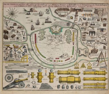
Erste Tafel in welcher alle gehörige Werk-Zeuge zur Kriegs-Kunst, und Artillerie, zu...
Christoph Weigel (*1654 - †1725)Reference 11937
Description
Old coloured engraving with numerous illustrations of siege and war technology by Christoph Weigel. Including different military equipment such as cannons, mortars, battle axes, various types of ships, as well as terrain sketches with situation. From Bequemer Schul- und Reisen-Atlas also titled Atlas scholasticus et itinerarius by Christoph Weigel. First published in Nuremberg in 1718. Weigel's well-known travel atlas, which he published in collaboration with Professor Johann David Köhler.
Details
| Cartographer | Christoph Weigel |
| Title | Erste Tafel in welcher alle gehörige Werk-Zeuge zur Kriegs-Kunst, und Artillerie, zu Belagerung der Staette Vestungen... |
| Publisher, Year | Johann Ernst Adelbulner, Nuremberg, 1718 |
| Plate Size | 33.2 x 40.2 cm (13.1 x 15.8 inches) |
| Sheet Size | 36.3 x 42.0 cm (14.3 x 16.5 inches) |
Condition
Cartographer
Images to Download
If you like to download the image of this map with a resolution of 1200 pixels, please follow the link below.
You can use this image for publication on your personal or commercial websites for free if you set a link to this website. If you need photographs with a higher resolution, please contact us.
Military - Weigel, Christoph - Erste Tafel in welcher alle gehörige...

