Product successfully added to your shopping cart
There are 0 items in your cart. There is 1 item in your cart.
Sea Monsters

Scotia - Descrittione dell'Isola di Scotia.
Simon Galignani, Girolamo Porro, Venice, 1572
First edition of Porcacchi's very attractive and early map of Scotland. This finely-executed map shows Scotland with the Orkney Islands, Shetlands and the Hebrides. With two sailing ships, compass...
Scotia - Descrittione dell'Isola di Scotia.
1572 - Tomaso Porcacchi
12362Antique map of Scotland. Printed in Venice by Simon Galignani, Girolamo Porro in 1572.
Sold
Irlanda - Descrittione dell'Isola d'Irlanda.
Simon Galignani, Girolamo Porro, Venice, 1572
First edition of Porcacchi's very attractive and early map of Ireland. This finely-executed map shows Ireland with north to the right. With a compass rose, title cartouche and several sea monsters....
Irlanda - Descrittione dell'Isola d'Irlanda.
1572 - Tomaso Porcacchi
12364Antique map of Ireland. Printed in Venice by Simon Galignani, Girolamo Porro in 1572.
Sold
Cuba - Cvba - Descrittione dell' Isola Cuba, che dal Colombo
Simon Galignani, Girolamo Porro, Venice, 1572
First edition of Porcacchi's very attractive and early map of Cuba. This finely-executed map shows the Caribbean island of Cuba with Jamaica and parts of Hispaniola. The Y de Lagartos shown north...
Cuba - Cvba - Descrittione dell' Isola Cuba, che dal Colombo
1572 - Tomaso Porcacchi
12366Antique map of Cuba, Jamaica, Cayman. Printed in Venice by Simon Galignani, Girolamo Porro in 1572.
Sold
Cipro - Descrittione dell'Isola di Cipro.
Simon Galignani, Girolamo Porro, Venice, 1572
First edition of Porcacchi's very attractive and early map of Cyprus. One of the earliest obtainable separate maps of Cyprus. This finely-executed map shows the Mediterranean island of Cyprus. With...
Cipro - Descrittione dell'Isola di Cipro.
1572 - Tomaso Porcacchi
12369Antique map of Cyprus. Printed in Venice by Simon Galignani, Girolamo Porro in 1572.
Sold
Mondo Nuovo - Descrittione dell'Isola et Terra di di Santa Croce, ouero Mondo Nuovo.
Simon Galignani, Girolamo Porro, Venice, 1572
The earliest obtainable map of North America. Printed in 1572.Rare first edition of Porcacchi's very attractive and early map of North America. The earliest obtainable map of North America,...
Mondo Nuovo - Descrittione dell'Isola et Terra di di Santa Croce, ouero...
1572 - Tomaso Porcacchi
12371Antique map of North America. Printed in Venice by Simon Galignani, Girolamo Porro in 1572.
Sold
Gotlandia - Descrittione dell'Isola di Gotlandia.
Simon Galignani, Girolamo Porro, Venice, 1572
First edition of Porcacchi's very attractive and early map of Gotland, the largest island of Sweden. This finely-executed map shows the island of Gotland in the Baltic Sea and is one of the...
Gotlandia - Descrittione dell'Isola di Gotlandia.
1572 - Tomaso Porcacchi
12372Antique map of Gotland. Printed in Venice by Simon Galignani, Girolamo Porro in 1572.
Sold
Malta - Descrittione dell'Isola di Malta.
Simon Galignani, Girolamo Porro, Venice, 1572
First edition of Porcacchi's very attractive and early map of Malta. This finely-executed map shows the Mediterranean island of Malta with Valetta. Oriented to the southwest. With a compass rose, a...
Malta - Descrittione dell'Isola di Malta.
1572 - Tomaso Porcacchi
12379Antique map of Malta. Printed in Venice by Simon Galignani, Girolamo Porro in 1572.
Sold
Sicilia - Descrittione dell'Isola di Sicilia.
Simon Galignani, Girolamo Porro, Venice, 1572
First edition of Porcacchi's very attractive and early map of Sicily (Sicilia). This finely-executed map shows the Mediterranean island of Sicily oriented to the north. With a compass rose, a...
Sicilia - Descrittione dell'Isola di Sicilia.
1572 - Tomaso Porcacchi
12381Antique map of Sicily, Sicilia. Printed in Venice by Simon Galignani, Girolamo Porro in 1572.
Sold
Minorica - Descrittione dell'Isola di Minorica.
Simon Galignani, Girolamo Porro, Venice, 1572
First edition of Porcacchi's very attractive and early map of Minorca, Balearic Islands (Islas Baleares). This finely-executed map shows the Balearic island of Minorca oriented to the east. With a...
Minorica - Descrittione dell'Isola di Minorica.
1572 - Tomaso Porcacchi
12383Antique map of Minorca, Balearic Islands. Printed in Venice by Simon Galignani, Girolamo Porro in 1572.
Sold
Maiorica - Descrittione dell'Isola di Maiorica.
Simon Galignani, Girolamo Porro, Venice, 1572
First edition of Porcacchi's very attractive and early map of Mallorca, Balearic Islands (Islas Baleares). This finely-executed map shows the Balearic island of Mallorca oriented to the east. With...
Maiorica - Descrittione dell'Isola di Maiorica.
1572 - Tomaso Porcacchi
12386Antique map of Mallorca, Majorca, Balearic Islands. Printed in Venice by Simon Galignani, Girolamo Porro in 1572.
Sold![Münster, Turkey, Asia Minor, 1574: [Asia Minor]]( "Sebastian Münster: [Asia Minor]")
[Asia Minor]
Heinrich Petri, Basle, 1574
Early, attractive woodcut map of Turkey. On lower right with Cyprus. On the full sheet. From the German edition of Sebastian Münster's Cosmography, titled Cosmographey oder beschreibung aller...
[Asia Minor]
1574 - Sebastian Münster
11318Antique woodcut map of Asia Minor. Printed in Basle by Heinrich Petri in 1574.
Sold
Beschreibung des Lands Pomern, sampt allen Hertzogthumben, Graueschafften und fürnemmen Stetten...
Heinrich Petri, Basle, 1574
Early woodcut map of the Pomerania by Sebastian Munster. Showing the coastal line of the Baltic Sea from Rügen, Usedom to Danzig (Gdansk). With nine coat of arms on top. From the German edition of...
Beschreibung des Lands Pomern, sampt allen Hertzogthumben,...
1574 - Sebastian Münster
11370Antique woodcut map of Rugen, Mecklenburg-West Pomerania. Printed in Basle by Heinrich Petri in 1574.
Sold
Beschreibung der Inselen unnd des gantzen Koenigreichs Sicilie.
Heinrich Petri, Basle, 1574
Early woodcut map of Sicily (Sicilia) by Sebastian Münster. On the full text sheet. From the German edition of Sebastian Münster's Cosmography, titled Cosmographey oder beschreibung aller Länder ,...
Beschreibung der Inselen unnd des gantzen Koenigreichs Sicilie.
1574 - Sebastian Münster
11389Antique woodcut map of Sicilia, Sicily. Printed in Basle by Heinrich Petri in 1574.
Sold
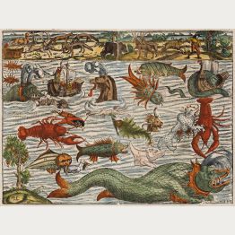
Mörwunder und seltzame thier, wie die in Mitnächtigen ländern gefunden werden
Heinrich Petri, Basle, 1574
One of the most sought after 16th century curiosities.The famous charts of mythical sea and land monsters by Sebastian Munster in beautiful colours. With fantastic fishes and lobsters...
Mörwunder und seltzame thier, wie die in Mitnächtigen ländern gefunden...
1574 - Sebastian Münster
11685Beautiful coloured woodcut of sea and land monsters. Published by Heinrich Petri and printed in Basel in 1574.
Sold
Das erst General, inhaltend die beschreibung und den Circkel des gantzen Erderichs und Möre
Heinrich Petri, Basle, 1574
16th Century Woodcut Map of the World.Early woodcut world map by Sebastian Münster. This 'modern' map of the world is an oval projection with a vigorous surround of clouds and lusty...
Das erst General, inhaltend die beschreibung und den Circkel des gantzen...
1574 - Sebastian Münster
1168716th century woodcut map of the world. Printed in Basle by Heinrich Petri in 1574.
Sold
Africae Tabula Nova
Nicolas Chesneau, Michel Sonnius, Paris, 1575
Ortelius' Africa Map as a Woodcut. Rare.A large and scarce woodcut map of Africa by Francois de Belleforest. Based on Ortelius' map of Africa from Theatrum Orbis Terrarum , but much rarer...
Africae Tabula Nova
1575 - Francois de Belleforest
11745Antique woodcut map of the African continent. Printed in Paris by Nicolas Chesneau, Michel Sonnius in 1575.
Sold
Descriptio Germaniae Inferioris
Gillis van den Rade, Antwerp, 1575
Old coloured antique map of the Low Countries with the Netherlands and Belgium by Abraham Ortelius. Shows the area from The Hague to Cologne and from Emden to Paris. Above a title band held by two...
Descriptio Germaniae Inferioris
1575 - Abraham Ortelius
11903Old coloured map of the Low Countries with Belgium and the Netherlands. Printed in Antwerp by Gillis van den Rade in 1575.
Sold
Africae Tabula Nova
Gillis van den Rade, Antwerp, 1575
Antique map of Africa by Abraham Ortelius. From the 1575 Latin edition of Theatrum Orbis Terrarum by Abraham Ortelius. Second state of the plate, still the date 1570 is present in the cartouche...
Africae Tabula Nova
1575 - Abraham Ortelius
12410Coloured map of the African continent. Printed in Antwerp by Gillis van den Rade in 1575.
Sold
Affricae tabula nova / Africa, Lybia, Morenlandt, mit allen Königreichen so jetziger Zeit darumb...
Petri, Basle, circa 1580
Attractive woodcut map showing the African continent. From a German edition of Cosmographia by Sebastian Munster printed from Petri in Basel 1580. "This map ... was based on Ortelius ... The coast...
Affricae tabula nova / Africa, Lybia, Morenlandt, mit allen Königreichen...
1580 - Sebastian Münster
10110Coloured woodcut map of the African continent. Printed in Basle by Petri circa 1580.
Sold
Regni Hispaniae Post Omnium Editiones Locuplettissima Descriptio
Antwerp, 1580
Original old coloured engraved map of Spain and Portugal by A. Ortelius. Showing the Iberian Peninsula with Balearic Islands and parts of northern Africa. With one large cartouche, a mileage scale,...
Regni Hispaniae Post Omnium Editiones Locuplettissima Descriptio
1580 - Abraham Ortelius
10874Old coloured map of Spain - Portugal. Printed in Antwerp in the year 1580.
Sold
Beschreibung des heiligen Landes Canaan
A. Duncker, Magdeburg, 1581
Decorative coloured uncommon woodcut map of Palestine / Israel from "Itinerarium Sacrae Scripturae" by Heinrich Bunting. His work was much valued after the first edition in 1581, mainly because of...
Beschreibung des heiligen Landes Canaan
1581 - Heinrich Bünting
10840Coloured woodcut map of Israel, Palestine. Printed in Magdeburg by A. Duncker in 1581.
Sold
Africa Tertia pars Terrae
Magdeburg, 1581
Rare and early woodcut map of Africa by Heinrich Bunting. The map has an unusual shape, tapering to a narrow angle in the south. Several rivers appear in West Africa and as tributaries to the Nile....
Africa Tertia pars Terrae
1581 - Heinrich Bünting
11197Coloured woodcut map of Africa. Printed in Magdeburg in the year 1581.
Sold
Zee Custe van Sweeden otrent de Westerwijck en tgatt vann Stockholm... Kalmar... en Rookoe
Cornelis Claesz, Amsterdam, 1583
Rare sea chart of the east coast of Sweden from the Zeespieghel by Lucas Janszoon Waghenaer. Shows the coastline between Kalmar, Kalmarsund, the northern part of Öland up to Stockholm. Splendidly...
Zee Custe van Sweeden otrent de Westerwijck en tgatt vann Stockholm......
1583 - Lucas Janszoon Waghenaer
12409Coloured sea chart of Sweden. Printed in Amsterdam by Cornelis Claesz in 1583.
Sold
Tartariae sive Magni Chami Regni Typus
Antwerp, 1584
Beautiful original old coloured copper engraved map of the Tartary by A. Ortelius. Showing large part of Asia from Black Sea with Russia, parts of China, a curious early treatment of Japan and an...
Tartariae sive Magni Chami Regni Typus
1584 - Abraham Ortelius
11336Old coloured map of the Northwestern US, Tartary. Printed in Antwerp in the year 1584.
Sold


![Münster, Turkey, Asia Minor, 1574: [Asia Minor]](https://www.vintage-maps.com/1543-home_default/muenster-turkey-asia-minor-1574.jpg "Sebastian Münster: [Asia Minor]")


