Product successfully added to your shopping cart
There are 0 items in your cart. There is 1 item in your cart.
Total products
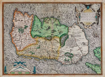
Eryn. Hiberniae, Britannicae Insulae, Nova Descriptio. Irlandt
Abraham Ortelius (*1527 - †1598)Old coloured map of Ireland. Printed in Antwerp by Christoffel Plantin in 1580 or 1589.
Reference 11897
Description
Old coloured antique map of Ireland by Abraham Ortelius. The west-oriented map is based on the large wall map of Great Britain by Mercator from 1564 and comes from a German Ortelius atlas of 1580 or 1589.
Decorated with a title cartouche, a cartouche with a milages scale and a sailing ship.
Details
| Cartographer | Abraham Ortelius |
| Title | Eryn. Hiberniae, Britannicae Insulae, Nova Descriptio. Irlandt |
| Publisher, Year | Christoffel Plantin, Antwerp, 1580 or 1589 |
| Plate Size | 35.5 x 48.2 cm (14.0 x 19.0 inches) |
| Sheet Size | 37.8 x 51.0 cm (14.9 x 20.1 inches) |
| Reference | Van den Broecke, M.: Ortelius Atlas Maps, No. 22; Van der Krogt, P.: Koeman's Atlantes Neerlandici, 5900:31A. |
Condition
Upper corners added in margin. Tear in centrefold backed at upper margin. Slightly browned. A good copy with beautiful old colours.
Cartographer
Abraham Ortelius was born 1527 in Antwerp. He studied mathematics, Greek and Latin and travelled a lot across Europe. He established a business in dealing with books and drawing maps. His first remarkable map was a 8 sheet world map in the year 1564, but only three copies have survived. In 1570 he issued the Theatrum Orbis Terrarum, the first modern Atlas with uniformly sized maps in a systematic collection. The term Atlas was not used until Mercator introduced it 20 years later. Most of the maps in Theatrum have been engraved by Frans Hogenberg. At the time of publication, the atlas was the most expensive book ever printed. Nevertheless it was a big success and around 7000 copies have been printed until 1612 in many editions and six different languages. Beside the Theatrum, Ortelius compiled a series of historical maps and published it in the Parergon Theatri which was bound with the Theatrum from 1579 onwards or published separately.
Images to Download
If you like to download the image of this map with a resolution of 1200 pixels, please follow the link below.
You can use this image for publication on your personal or commercial websites for free if you set a link to this website. If you need photographs with a higher resolution, please contact us.
Abraham Ortelius: Eryn. Hiberniae, Britannicae Insulae, Nova Descriptio. Irlandt.
Old coloured map of Ireland. Printed in Antwerp by Christoffel Plantin in 1580 or 1589.
Ireland - Ortelius, Abraham - Eryn. Hiberniae, Britannicae Insulae, Nova...

