Product successfully added to your shopping cart
There are 0 items in your cart. There is 1 item in your cart.
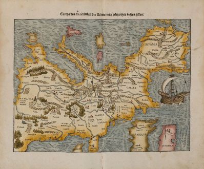
Europa das ein Drittheil der Erden, nach gelegenheit unsern zeiten.
Sebastian Münster (*1489 - †1552)Reference 11688
Description
16th Century Woodcut Map of Europe.
One of the earliest printed maps of the European continent. Curiously oriented to the south. Shows the continent from Constantinople and Greece to the east and Spain to the southwest. With Denmark, England, Scotland and Ireland to the bottom of the map. Decorated with a beautiful sailing ship. Letterpress title on top. A large woodcut border surrounds the title on verso. From Sebastian Münster's Cosmography, published 1574 by Heinrich Petri in Basel.
Details
| Cartographer | Sebastian Münster |
| Title | Europa das ein Drittheil der Erden, nach gelegenheit unsern zeiten. |
| Publisher, Year | Heinrich Petri, Basle, 1574 |
| Plate Size | 25.5 x 34.0 cm (10.0 x 13.4 inches) |
| Sheet Size | 33.5 x 40.3 cm (13.2 x 15.9 inches) |
Condition
Cartographer
Images to Download
If you like to download the image of this map with a resolution of 1200 pixels, please follow the link below.
You can use this image for publication on your personal or commercial websites for free if you set a link to this website. If you need photographs with a higher resolution, please contact us.
Europe Continent - Münster, Sebastian - Europa das ein Drittheil der Erden, nach...

![[Map of Europe] [Map of Europe]](https://www.vintage-maps.com/2931-home_default/bordone-europe-continent-1528-1565.jpg)
![Aldenburg [Aldenbvrg] Aldenburg [Aldenbvrg]](https://www.vintage-maps.com/2177-home_default/muenster-germany-lower-saxony-stade-1574.jpg)
