Product successfully added to your shopping cart
There are 0 items in your cart. There is 1 item in your cart.
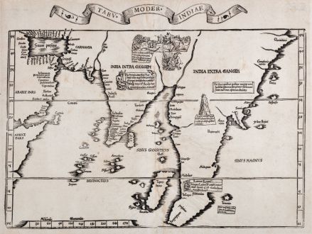
Tabu. moder. Indiae
Laurent Fries (*1485 - †1532)Reference 11895
Description
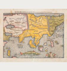
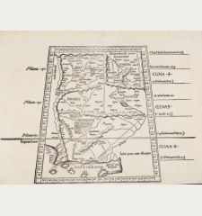
Early and important woodcut map of Asia by Laurent Fries after Martin Waldseemüller. This woodcut map comes from the 1535 Lyon edition of Ptolemy's Geographia. One of the earliest representations of the Portuguese discoveries in Asia and an important document on the early cartography of the Asian continent and Southeast Asia.
The woodcut map shows the Horn of Africa and the Arabian Peninsula with the Persian Gulf in the west. India and Sri Lanka are almost realistically represented, the Malay Peninsula is very dominant. In the northeast reaching up to China. The cartography is largely based upon the Johannes Ruysch world map of 1507.
Thomas Suarez in Early Mapping of Southeast Asia about this map of the Asian continent:
The modern map of Asia is geographically unchanged from the 1513 version as regards the delineation of the coasts, but is now embellished with annotations and vignettes. One of these, a generica image of a king lying above Malacca in the southern portion of Malaya, represents a kingdom not found on the 1513 prototype. It is said to be the kindgom of Lamai. This is a corruption of the Lamia of the 1507 Waldseemüller map (the last two letters being reversed), which we have identified as Lan Na (Chiang Mai). The only missing ingredient to clinch the identity of Fries' Lamai as Lan Na is the kingdom's namesake lake, which appeared on the Ruysch and Waldseemüller maps, but is lacking on the Fries version... The inscription notes that silver and silks are transported from Lamai to Malacca.
The origin of this map is the first so called "Modern Atlas" by Martin Waldseemuller since it is the first Ptolemy edition with twenty new regional maps beside the traditional twenty-seven Ptolemaic maps derived from the 1482 Ulm edition. The Atlas is titled Geographie opus Novissima Traductione e Grecorum Archetypis and published by Johann Schott in Strasbourg in 1513 and is one of the most important edition of the Ptolemy Atlases. In 1520 a second edition of the atlas was printed by Schott from the same woodcut blocks. It was reissued in 1522 and 1525 by Laurent Fries and Johannes Gruninger with size reduced maps. The wood blocks of Fries found their way into the ownership of Melchior and Gaspar Trechsel in Lyon.
Details
| Cartographer | Laurent Fries |
| Title | Tabu. moder. Indiae |
| Publisher, Year | M. & G. Trechsel, Lyon, 1535 |
| Plate Size | 33.5 x 44.5 cm (13.2 x 17.5 inches) |
| Sheet Size | 36.5 x 48.2 cm (14.4 x 19.0 inches) |
| Reference | Karrow, R. W.: Mapmakers of the Sixteenth Century and their Maps, (16 c.) 28/44 |
Condition
Cartographer
Images to Download
If you like to download the image of this map with a resolution of 1200 pixels, please follow the link below.
You can use this image for publication on your personal or commercial websites for free if you set a link to this website. If you need photographs with a higher resolution, please contact us.

![Tabula nova Hispaniae [Tabula noua Hispaniae] Tabula nova Hispaniae [Tabula noua Hispaniae]](https://www.vintage-maps.com/3236-home_default/fries-spain-portugal-1541.jpg)
![[De Boemia. / Tabula quarta & quinta Europae de nonnullis / Germaniae ...] [De Boemia. / Tabula quarta & quinta Europae de nonnullis / Germaniae ...]](https://www.vintage-maps.com/2304-home_default/fries-germany-1541.jpg)
![[Tab. Mo. Primae Partis Aphricae et Tabula Secunde partis Aphricae.] [Tab. Mo. Primae Partis Aphricae et Tabula Secunde partis Aphricae.]](https://www.vintage-maps.com/3651-home_default/fries-north-africa-1525.jpg)
