Product successfully added to your shopping cart
There are 0 items in your cart. There is 1 item in your cart.
Total products
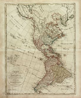
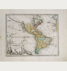
Charte von America nach astronomischen Bestimmungen, den neusten Nachrichten und...
Homann ErbenOld coloured map of the American continent. Printed in Nuremberg by Homann Erben in 1806.
Reference 11295
Description
Copper engraved map of America, published in 1806 by Homann Heirs. The detailed map is not exactly aligned to the north and shows the latest discoveries of the late 18th Century. The details in the Northwest Pacific are based on the Lewis & Clark Expedition. The coastline to the north is shown by dashed lines and labeled 'Wahrscheinliche Küste' (probable coast line) and 'Gäntzlich unbekannte Küste' (totally unknown coast line). The archipelago of Hawaii is referred as 'Sandwich Inseln', and the individual island names are shown using the early phonetic spelling. Between California and Hawaii is an archipelago located with Spanish names. These islands were introduced on maps in the mid-18th century, not corrected until the early 19th century.
Details
| Cartographer | Homann Erben |
| Title | Charte von America nach astronomischen Bestimmungen, den neusten Nachrichten und Charten entworfen von F. L. Güsselfeld. |
| Publisher, Year | Homann Erben, Nuremberg, 1806 |
| Plate Size | 57.7 x 44.8 cm (22.7 x 17.6 inches) |
| Sheet Size | 63.0 x 54.2 cm (24.8 x 21.3 inches) |
Condition
Slightly dusty and stained. Very good condition.
Cartographer
Johann Baptist Homann was born 1664 in Oberkammlach. He founded his business 1602 in Nuremberg, Germany. After a long period of Dutch domination in map publishing, the Homann publishing house became the most important map and atlas producer in Germany. He became a member of the Academy of Science in Berlin just after he published his first atlas in 1707. After his death 1724 in Nuremberg, the company was continued by his son Johann Christoph. The publishing firm was bequeathed to his heirs after his death in 1730 and was traded under the name Homann Heirs until the next century.
Images to Download
If you like to download the image of this map with a resolution of 1200 pixels, please follow the link below.
You can use this image for publication on your personal or commercial websites for free if you set a link to this website. If you need photographs with a higher resolution, please contact us.
Homann Erben: Charte von America nach astronomischen Bestimmungen, den neusten Nachrichten und Charten entworfen von F. L. Güsselfeld..
Old coloured map of the American continent. Printed in Nuremberg by Homann Erben in 1806.
America Continent - Homann Erben - Charte von America nach astronomischen...

