
Product successfully added to your shopping cart
There are 0 items in your cart. There is 1 item in your cart.
Antique Maps by George Matthäus Seutter (*1678 - †1757)
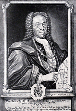
George Matthaus Seutter, a German publisher, cartographer and engraver from Augsburg, was born 1678 as the son of a goldsmith. After an apprenticeship at J. B. Homann in Nuremberg, he returned to his native city of Augsburg and worked in the publishing firm of Jeremiah Wolf. In 1707 he founded his own successful publishing company and produced maps, atlases and globes. Seutter died in 1757. The company went over to his son Albrecht Carl and his stepsons G. B. Probst and T. C. Lotter in after his death in 1757. The latter being regarded as his true successor. According to C. Sandler, following atlases have been published by Seutter:
- Atlas Geographicus oder Accurate Vorstellung der Ganzen Welt, 1725
- Atlas Compendiosus oder die ganze Welt in den nothwendigsten Geographischen Charten
- Atlas Compendiosus Scholasticus
- Atlas Novus Indicubus Instructus, 1728
- Grosser Atlas, 1734
- Atlas Minor, 1744
Beside the atlases, Seutter produced a pair of 20 cm table globes during his early days.

Lacus Bodamicus vel Acronius cum regionibus circumjacentibus recens delineatus a Matthaeo...
M. Seutter, Augsburg, circa 1740
Old coloured antique map of the Lake Constance by Matthäus Seutter. Probably the most detailed map of the Lake Constance region of the 18th century. The map shows the administrative districts...
Lacus Bodamicus vel Acronius cum regionibus circumjacentibus recens...
1740 - George Matthäus Seutter
11866Old coloured map of the Bodensee, Lake of Constance, Baden-Württemberg. Printed in Augsburg by M. Seutter circa 1740.
Sold
Symbolische Sinnreiche in einer Belagerung... Versuchungen der Liebe... Representation symbolique...
G. M. Seutter, Augsburg, circa 1740
Seutter's famous allegorical map representing the battle of the sexes and of love. In style of a typical 18th century battle plan.Jeffrey N. Peters describes this map in The History of...
Symbolische Sinnreiche in einer Belagerung... Versuchungen der Liebe......
1740 - George Matthäus Seutter
12420Fantasy map by G. M. Seutter, printed in Ausburg around 1740.
Sold
Nova Mappa Maris Nigri et Freti Constantinopolitani
Augsburg, circa 1741
Original hand coloured copper engraving of Matthaeus Seutter. Showing the Black Sea, Crimea and Bosporus. With large inset map Istanbul / Constantinople and the Bosporus.
Nova Mappa Maris Nigri et Freti Constantinopolitani
1741 - George Matthäus Seutter
10142Old coloured map of Constantinople, Black Sea. Printed in Augsburg circa 1741.
Sold
Representation la Plus Nouvelle et Exacte de l'Ile Martinique, la Premiere des Iles de l'Amerique...
Augsburg, 1745
Beautiful map of the French Caribbean Island of Martinique by M. Seuter. With a stunning cartouche, a naval battle and a compass rose. Engraved by Albrecht Carl Seutter (1722-1762).
Representation la Plus Nouvelle et Exacte de l'Ile Martinique, la...
1745 - George Matthäus Seutter
11507Old coloured map of Martinique. Printed in Augsburg in the year 1745.
Sold
Representation la Plus Nouvelle et Exacte de l'Ile Martinique, la Premiere des Iles de l'Amerique...
Augsburg, 1745
Beautiful map of the French Caribbean Island of Martinique by M. Seuter. With a stunning cartouche, a naval battle and a compass rose. Engraved by Albrecht Carl Seutter (1722-1762).
Representation la Plus Nouvelle et Exacte de l'Ile Martinique, la...
1745 - George Matthäus Seutter
12085Old coloured map of Martinique. Printed in Augsburg in the year 1745.
Sold
Tabula Anemographica seu Pyxis Nautica, vulgo Compass Charte
T. C. Lotter, Augsburg, circa 1760
Wind map in stile of a wind rose. Original old colouring by the publisher.
Tabula Anemographica seu Pyxis Nautica, vulgo Compass Charte
1760 - George Matthäus Seutter
10298Old coloured wind map. Printed in Augsburg by T. C. Lotter circa 1760.
Sold


