Product successfully added to your shopping cart
There are 0 items in your cart. There is 1 item in your cart.
Antique Maps by George Matthäus Seutter (*1678 - †1757)
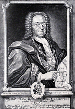
George Matthaus Seutter, a German publisher, cartographer and engraver from Augsburg, was born 1678 as the son of a goldsmith. After an apprenticeship at J. B. Homann in Nuremberg, he returned to his native city of Augsburg and worked in the publishing firm of Jeremiah Wolf. In 1707 he founded his own successful publishing company and produced maps, atlases and globes. Seutter died in 1757. The company went over to his son Albrecht Carl and his stepsons G. B. Probst and T. C. Lotter in after his death in 1757. The latter being regarded as his true successor. According to C. Sandler, following atlases have been published by Seutter:
- Atlas Geographicus oder Accurate Vorstellung der Ganzen Welt, 1725
- Atlas Compendiosus oder die ganze Welt in den nothwendigsten Geographischen Charten
- Atlas Compendiosus Scholasticus
- Atlas Novus Indicubus Instructus, 1728
- Grosser Atlas, 1734
- Atlas Minor, 1744
Beside the atlases, Seutter produced a pair of 20 cm table globes during his early days.

Bohemia Regnum juxta XII. Circulos divisum, cum Comitatu Glacensi et ditione Egrana, nec non...
M. Seutter, Augsburg, circa 1720
Large original old coloured map of Bohemia by M. Seutter. With two decorative cartouches and a city view of Carlsbad. Centred around Prague (Praha).
Bohemia Regnum juxta XII. Circulos divisum, cum Comitatu Glacensi et...
1720 - George Matthäus Seutter
10409Coloured map of Carlsbad. Printed in Augsburg by M. Seutter circa 1720.
Sold
Lacus Bodamicus vel Acronius cum regionibus circumjacentibus recens delineatus a Matthaeo...
M. Seutter, Augsburg, circa 1720
Old colored engraved map of the Lake Constance by Matthew Seutter. Probably the most detailed map of the Lake Constance region in the 18th Century. The now rare map shows the administrative...
Lacus Bodamicus vel Acronius cum regionibus circumjacentibus recens...
1720 - George Matthäus Seutter
11142Old coloured map of the Bodensee, Lake of Constance, Baden-Württemberg. Printed in Augsburg by M. Seutter circa 1720.
Sold
Imperium Romano-Germanicum in suos Circulos, Electorat et Status Summa cura et Studio divisum...
M. Seutter, Augsburg, circa 1730
Nice old coloured map of Central Europe by M. seutter. Showing the Low Countries in the West, via Germany centred to Poland in the East. Switzerland and Northern Italy at the bottom. With two large...
Imperium Romano-Germanicum in suos Circulos, Electorat et Status Summa...
1730 - George Matthäus Seutter
10420Old coloured map of Central Europe. Printed in Augsburg by M. Seutter circa 1730.
Sold
L'Eveche et L'Etat de Liege Avec les appartenances designées dans les pais voisins Delineation...
M. Sutter, Augsburg, circa 1730
Beautiful cooper engraved map of the central part of Belgium and parts of the Netherlands by M. Seutter. Showing the area around Liège and Maastricht. The nice cartouche with two Belgium Lions.
L'Eveche et L'Etat de Liege Avec les appartenances designées dans les...
1730 - George Matthäus Seutter
10427Coloured map of Liege. Printed in Augsburg by M. Sutter circa 1730.
Sold
Saxoniae Inferioris Circulus juxta Principatus
M. Seutter, Augsburg, circa 1730
Old coloured map of northern part of Germany by M. Seutter. Covering the area of Lower Saxony, Mecklenburg-Vorpommern and Schleswig-Holstein up to Berlin in the East. With a figurative cartouche.
Saxoniae Inferioris Circulus juxta Principatus
1730 - George Matthäus Seutter
10464Coloured map of North Germany. Printed in Augsburg by M. Seutter circa 1730.
Sold
Imperii Moscovitici pars Australis...
Augsburg, circa 1730
Original old coloured map of the region around Moscow by Matthaeus Seutter. With Poland and Lithuania to the west, Ukraine to the south-west and Tartary with Siberia to the east. Very detailed with...
Imperii Moscovitici pars Australis...
1730 - George Matthäus Seutter
11481Old coloured map of Moskwa, Moscow. Printed in Augsburg circa 1730.
Sold
Accurata Utopiae Tabula das ist der Neu-Entdeckten Schalck-Welt, oder des so Offt Benannten und...
G. M. Seutter, Augsburg, circa 1730
The famous fantasy map of Utopia.Schlaraffenland stand for the Land of Cockaigne in German and represents a country of idleness and luxury. This is a totally imaginary map, but...
Accurata Utopiae Tabula das ist der Neu-Entdeckten Schalck-Welt, oder...
1730 - George Matthäus Seutter
11487Old coloured map of Cockaigne, Utopia. Printed in Augsburg by G. M. Seutter circa 1730.
Sold
India Orientalis, cum Adjacentibus Insulis Nova Delineatione ob Oculos Posita
Augsburg, circa 1730
Beautiful map of Southeast Asia by M. Seutter. With a stunning cartouche and a compass rose. First edition, without the privilege but with the name of the engraver Andreas Silbereisen.
India Orientalis, cum Adjacentibus Insulis Nova Delineatione ob Oculos...
1730 - George Matthäus Seutter
11695Old coloured map of Southeast Asia. Printed in Augsburg circa 1730.
Sold
Mare Mediterraneum, juxta Regna et Provincias, quas Alluit Distinctum et Cognominatum
Augsburg, circa 1730
Beautiful, old-colored engraved map of the western Mediterranean by Matthaeus Seutter. Shows the neighboring countries of Spain, Italy, the Balkans, Greece, as well as the north coast of Africa...
Mare Mediterraneum, juxta Regna et Provincias, quas Alluit Distinctum et...
1730 - George Matthäus Seutter
11705Old coloured map of the Mediterranean Sea. Printed in Augsburg circa 1730.
Sold
Imperii Moscovitici Pars Australis in Lucem Edita par Guillielmum De L'Isle ...
Augsburg, circa 1730
Original old coloured map of the region around Moscow by Matthaeus Seutter. With Poland and Lithuania to the west, Ukraine to the south-west and Tartary with Siberia to the east. Very detailed with...
Imperii Moscovitici Pars Australis in Lucem Edita par Guillielmum De...
1730 - George Matthäus Seutter
11706Old coloured map of Moskwa, Moscow. Printed in Augsburg circa 1730.
Sold
München, die weitberühmt, praechtig und wohl fortificirte Chur-Fürstl. Haupt u. Residenz Stadt...
M. Seutter, Augsburg, circa 1730
Large, old coloured engraved plan of the city of Munich by Matthäus Seutter. With city fortification and determination of individual buildings, as well as detailed key. Left with a small inset view...
München, die weitberühmt, praechtig und wohl fortificirte Chur-Fürstl....
1730 - George Matthäus Seutter
11840Old coloured city plan of Munich, Bavaria. Printed in Augsburg by M. Seutter circa 1730.
Sold
Lipsia ... - Leipzig, eine florisante, auch befestigte Handels- Stadt und weitberühmte...
M. Seutter, Augsburg, circa 1730
Large, old coloured town plan of the city of Leipzig by Matthäus Seutter. With fortification and important buildings. To the right the coat of arms of Leipzig. To the lower third a panoramic view...
Lipsia ... - Leipzig, eine florisante, auch befestigte Handels- Stadt...
1730 - George Matthäus Seutter
12054Old coloured city plan of Leipzig, Saxony. Printed in Augsburg by M. Seutter circa 1730.
Sold
Despriptio Geographica Praefecturarum Doelitsch, Bitterfeld, Zoerbig
G. M. Seutter, Augsburg, circa 1730
Antique map of Delitzsch, Bitterfeld and Zörbig by G. M. Seutter. With Raghun in the north to Strehla near Radefeld in the south, from Löbejun in the west to Schnaditz in the east. Very detailed...
Despriptio Geographica Praefecturarum Doelitsch, Bitterfeld, Zoerbig
1730 - George Matthäus Seutter
12056Old coloured map of Bitterfeld, Sachsen-Anhalt. Printed in Augsburg by G. M. Seutter circa 1730.
Sold
Regnum Norwegiae Accurata et Novissima Delineatione juxta V. Praefecturas Generales...
G. M. Seutter, Augsburg, circa 1730
Large antique map of Norway by Georg Matthäus Seutter. Top left an inset map with the Lofoten to the North Cape. The beautiful title cartouche shows the Norwegian coat of arms, fishermen, fishing...
Regnum Norwegiae Accurata et Novissima Delineatione juxta V....
1730 - George Matthäus Seutter
12567Old coloured map of Norway. Printed in Augsburg by G. M. Seutter circa 1730.
Sold
Ducatus Luxemburg Distintis Limitibus Majorum et Minorum Ditionum Exacte Designatus et in Lucem...
G. M. Seutter, Augsburg, circa 1730
Very detailed antique map of Luxembourg (Luxembourg) by Georg Matthäus Seutter. In the east the Moselle with Diedenhofen and Trier, in the west the Meuse with Huy, Namur and Charleville-Mézières....
Ducatus Luxemburg Distintis Limitibus Majorum et Minorum Ditionum Exacte...
1730 - George Matthäus Seutter
12568Old coloured map of Luxembourg. Printed in Augsburg by G. M. Seutter circa 1730.
Sold
Holmia celeberrima Metropolis et Sedes Regia Regni Sueciae ... Stockholm die vortreffliche Haupt...
M. Seutter, Augsburg, circa 1730
Large, old coloured plan of the city of Stockholm by Matthäus Seutter. Shows the Swedish capital Stockholm with surroundings and the archipelago. At the top a panorama with figurative and maritime...
Holmia celeberrima Metropolis et Sedes Regia Regni Sueciae ... Stockholm...
1730 - George Matthäus Seutter
12658Old coloured city plan of Stockholm. Printed in Augsburg by M. Seutter circa 1730.
Sold
Nova et accuratissima Urbis St. Petersburg ... / Neue u. Accurate abbildung der der von dem...
M. Seutter, Augsburg, 1734
A fine, detailed townplan of St. Petersburg with a map of the surrounding region by Matthaus Seutter in original old colours. The plan with determination of individual buildings and an extensive...
Nova et accuratissima Urbis St. Petersburg ... / Neue u. Accurate...
1734 - George Matthäus Seutter
11193Old coloured town view of Saint Petersburg. Printed in Augsburg by M. Seutter in 1734.
Sold
Ulma Memorabilis ac Permunita Libera Imperii Civitas ad Danubium... / Ulm eine Considerable Freye...
M. Seutter, Augsburg, circa 1735
Large, old colored engraved city map of Ulm by Matthaus Seutter. The overall perspective plan with determination of individual buildings as well as detailed explanations. In the lower third the...
Ulma Memorabilis ac Permunita Libera Imperii Civitas ad Danubium... /...
1735 - George Matthäus Seutter
11154Old coloured map of Ulm, Baden-Württemberg. Printed in Augsburg by M. Seutter circa 1735.
Sold
Wratislavia Antiquissima et Celeberrima Ducat. Silesiaci Metropolis ... / Breslau due Uhralte u...
M. Seutter, Augsburg, circa 1735
Large, old coloured engraved city map of Wroclaw by Matthaus Seutter. The overall perspective plan with determination of individual buildings as well as detailed explanations. In the lower third a...
Wratislavia Antiquissima et Celeberrima Ducat. Silesiaci Metropolis ......
1735 - George Matthäus Seutter
11166Old coloured map of Wroclaw, Silesia. Printed in Augsburg by M. Seutter circa 1735.
Sold
Hispania ex Archetypo Roderici Mendez Sylvae et Variis Relationibus ...
Augsburg, circa 1735
Old coloured antique map of Spain and Portugal with the Balearic Islands (Mallorca, Menorca, Ibiza and Formentera) and parts of North Africa by G. M. Seutter. After the map of Rodrigo Mendez Silva...
Hispania ex Archetypo Roderici Mendez Sylvae et Variis Relationibus ...
1735 - George Matthäus Seutter
11812Old coloured map of Spain - Portugal. Printed in Augsburg circa 1735.
Sold
Nova et accuratissima Maris Caspii hactenus maximam partem nobis non satis cogniti ac Regionum...
Augsburg, circa 1740
Original hand coloured copper engraving of Matthaeus Seutter. Showing the Caspian Sea (Каспийское море) with the...
Nova et accuratissima Maris Caspii hactenus maximam partem nobis non...
1740 - George Matthäus Seutter
10147Old coloured map of the Caspian Sea, Russia. Printed in Augsburg circa 1740.
Sold
Nova et Accurata Hungariae cum adiacentib. Regn. et Principatibus Tabula
M. Seutter, Augsburg, circa 1740
Original old coloured map of the Balkan by M. Seutter. Showing Hungary, Serbia, Croatia, Bosnia and Herzegovina and Albania. With two beautiful cartouches.
Nova et Accurata Hungariae cum adiacentib. Regn. et Principatibus Tabula
1740 - George Matthäus Seutter
10410Old coloured map of Serbia, Croatia, Hungaria. Printed in Augsburg by M. Seutter circa 1740.
Sold
Lacus Bodamicus vel Acronius cum regionibus circumjacentibus recens delineatus a Matthaeo...
M. Seutter, Augsburg, circa 1740
Old coloured antique map of the Lake Constance by Matthäus Seutter. Probably the most detailed map of the Lake Constance region of the 18th century. The map shows the administrative districts...
Lacus Bodamicus vel Acronius cum regionibus circumjacentibus recens...
1740 - George Matthäus Seutter
11866Old coloured map of the Bodensee, Lake of Constance, Baden-Württemberg. Printed in Augsburg by M. Seutter circa 1740.
Sold
Symbolische Sinnreiche in einer Belagerung... Versuchungen der Liebe... Representation symbolique...
G. M. Seutter, Augsburg, circa 1740
Seutter's famous allegorical map representing the battle of the sexes and of love. In style of a typical 18th century battle plan.Jeffrey N. Peters describes this map in The History of...
Symbolische Sinnreiche in einer Belagerung... Versuchungen der Liebe......
1740 - George Matthäus Seutter
12420Fantasy map by G. M. Seutter, printed in Ausburg around 1740.
Sold


