Product successfully added to your shopping cart
There are 0 items in your cart. There is 1 item in your cart.
Total products
Atlas geographicus omnes orbis terrarum regiones in XLI tabulis ... / Atlas...
Leonhard Euler (*1707 - †1783)Rare Atlas of the Mathematician Leonhard Euler in outstanding conservation
Reference 11294
Description
First edition of the rare Atlas by the famous mathematician Leonhard Euler. The second edition was published in 1760 with 44 maps, followed by the third unaltered edition in 1777, which was printed until 1784.
The Atlas was published on behalf of the Royal Prussian Academy of Sciences in Berlin by Leonhard Euler, designed specifically for the use in classrooms. The maps, mostly based on works of Johann Christoph Rhode were mostly engraved by Nicolaus Friedrich Sauerbrey.
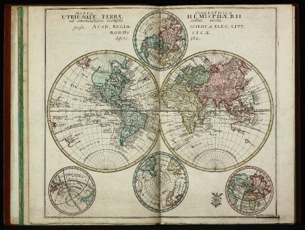
The present edition includes a title page, a 10-page preface by Leonhard Euler in Latin and French, 41 double-page engraved maps as mentioned in the title and preface, plus 4 additional maps. Each map is old coloured by a contemporary hand and has a stamp of the Academy of Sciences. The following maps are included:
4 world maps (one on two double leaves)
4 maps of the continents (Africa, Asia, America and Europe)
1 map of North America on 4 double leaves
1 map of Europe on 4 double leaves
4 maps of Britain
1 map of Russia
1 map of the Turkish Empire
1 map of the Holy Land
1 map of the Pacific ocean Mare pacificum
16 maps mainly of European countries (Scandinavia, Denmark, Greece, Italy, Spain, France, Germany, Poland, East Prussia, and more)
4 additionally bound maps: a sample map with geographical measurement instructions, Principatus Anhaltini, Landgrav. Thuringiae and Marchionat. Misniae
All maps of this atlas are shown on my new Atlas Gallery website: Euler Atlas
Details
| Cartographer | Leonhard Euler |
| Title | Atlas geographicus omnes orbis terrarum regiones in XLI tabulis ... / Atlas géographique représentant en XLI cartes toutes les regions de la terre ... |
| Publisher, Year | Michaelis, Berlin, 1753 |
| Size | 35.5 x 23.0 cm (14.0 x 9.1 inches), Folio |
| Collation | 12 pages |
| Illustrations | 45 double page copper engraved maps |
| Cover | Calf binding with gilt on spine |
| Reference | Phillips III, 3500 |
Condition
Slightly rubbed.
Title and preface with moderate age spotting, maps occasionally slightly stained. Overall outstanding conservation.
Cartographer
Leonhard Euler was born 1707 in Basel and has been one of the most famous mathematician. From 1720 he studied at the University of Basel by Johann Bernoulli. From 1727 he was Professor for Mathematics and Physics at the University of Saint Petersburg. 1741 he followed a call of Frederick II of Prussia to the Berlin Academy. After 25 years in Berlin he left for Saint Petersburg a second time. He died 1783 in Saint Petersburg.
Images to Download
If you like to download the image of this map with a resolution of 1200 pixels, please follow the link below.
You can use this image for publication on your personal or commercial websites for free if you set a link to this website. If you need photographs with a higher resolution, please contact us.
Leonhard Euler: Atlas geographicus omnes orbis terrarum regiones in XLI tabulis ... / Atlas géographique représentant en XLI cartes toutes....
Rare Atlas of the Mathematician Leonhard Euler in outstanding conservation
Atlases - Euler, Leonhard - Atlas geographicus omnes orbis terrarum...


![Ch'onha Chido [Atlas of all under Heaven] Ch'onha Chido [Atlas of all under Heaven]](https://www.vintage-maps.com/3336-home_default/anonymous-korean-manuscript-atlas-chonha-chido-1820.jpg)
![Ch'onha Chido [Atlas of all under Heaven] Ch'onha Chido [Atlas of all under Heaven]](https://www.vintage-maps.com/4291-home_default/anonymous-korean-manuscript-atlas-chonha-chido-1800.jpg)
![Ch'onha chido [Atlas of all under Heaven] Ch'onha chido [Atlas of all under Heaven]](https://www.vintage-maps.com/3314-home_default/anonymous-korean-woodblock-atlas-chonha-chido-1750.jpg)