Product successfully added to your shopping cart
There are 0 items in your cart. There is 1 item in your cart.
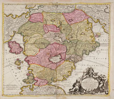
Accurata Utopiae tabula. Das ist der neu entdeckten Schalck Welt, oder des so offt...
Pieter Schenk (*1655 - †1718)Reference 12421
Description
Rare original edition of the famous fantasy map of Utopia.
Schlaraffenland means Land of Cockaigne in German and represents a country of idleness and luxury. This is a totally imaginary map, but constructed in conventional forms. The map is divided in 19 provinces, each refers to a vice or a sin:
- Senectas regio (doter land)
- Iuventae Regnum (youth land)
- Stultorum regnum (fool land)
- Bibonia Regnum (carouser land)
- Magni Stomachi Imperium (land of large stomach)
- Pigritarium regio (sluggard land)
- Terra Sancta Incognita (wishful thinking land)
- Mammonia (niggard land)
- Schlaraffenland
- Tartaria regnum (empire of hell)
- Res Publica Veneria (land of bawdiness)
- Lusoria (land of gambling)
- Iuronia regnum (curse land)
- Lurconia Regnum (gourmandise land)
- Prodigalia regnum (waste land)
- Insulae Negromanticae
- Insel Tobaco
After Koeman, this example seems to be the original edition published in 1700/10. The more common editions of this map by Homann and Seutter appeared a few years later.
Details
| Cartographer | Pieter Schenk |
| Title | Accurata Utopiae tabula. Das ist der neu entdeckten Schalck Welt, oder des so offt benanten, und doch nie erkanten Schlarraffenlandes ... durch Author anonymu |
| Publisher, Year | P. Schenk, 1700-10 |
| Plate Size | 48.2 x 55.8 cm (19.0 x 22.0 inches) |
| Sheet Size | 52.5 x 60.5 cm (20.7 x 23.8 inches) |
| Reference | Hill, G.: Cartographic Curiosities, pp. 57-58. |
Condition
Cartographer
Images to Download
If you like to download the image of this map with a resolution of 1200 pixels, please follow the link below.
You can use this image for publication on your personal or commercial websites for free if you set a link to this website. If you need photographs with a higher resolution, please contact us.
Curiosities - Schenk, Pieter - Accurata Utopiae tabula. Das ist der neu...

